This practical deployment guide for new and existing ArcGIS and SAP HANA users explains key tasks and concepts such as the deployment lifecycle, compatibility checks, client configuration, geodatabase creation, access management, and upgrades.
It is intended for database administrators, geodatabase administrators, and GIS platform administrators. Keep the Introduction to enterprise geodatabases in SAP HANA help topic available as the central reference while you work through the setup process.
SAP HANA and ArcGIS
When you enable an enterprise geodatabase in an existing SAP HANA database, ArcGIS creates geodatabase system objects—such as tables, views, functions, and procedures—in the database. These objects store and manage geodatabase metadata and support geodatabase functionality, including, but not limited to, attribute domains, topology, and relationship classes.
Existing tables that are not registered with the geodatabase continue to coexist with datasets managed by the geodatabase.
Before installing or changing any component, verify that the database release, operating system, any ArcGIS clients (such as ArcGIS Pro or ArcGIS Enterprise), and SAP HANA client are supported. If your environment includes multiple ArcGIS client releases, confirm compatibility for every release that will connect to the database.
To do so, see the following resources:
- Review ArcGIS requirements for using SAP HANA.
- Check compatibility between ArcGIS clients and geodatabases in SAP HANA.
- For a concise support lookup, see What SAP HANA database versions are supported by ArcGIS Enterprise and ArcGIS Pro?
Install a supported 64-bit SAP HANA client on every machine running ArcGIS Pro and on every machine in each ArcGIS Server site that will connect to the database. The SAP HANA client includes the SAP HANA ODBC driver that ArcGIS uses to communicate with the database.
Prerequisites
Deployment is a coordinated workflow. The database administrator prepares the database and creates the required database account, while the geodatabase administrator connects from ArcGIS and enables geodatabase functionality.
|
Database administrator (system user) |
Geodatabase administrator (sde user) |
|
| What it is | An operational role, person, or team responsible for managing the SAP HANA platform | A specific database user account required by ArcGIS, named sde |
| Naming requirement | No fixed username; varies by organization | A standard database user named sde |
| Primary scope | SAP HANA platform administration tasks such as security, users, roles, backups, monitoring, and maintenance | Geodatabase administration tasks such as enabling the geodatabase, managing geodatabase locks, and performing geodatabase upgrades |
| Key setup responsibility | Creates required accounts and grants required privileges | Uses ArcGIS tools to enable and manage the geodatabase |
| Geodatabase creation responsibility | Prepares prerequisites for geodatabase enablement | Runs the Enable Enterprise Geodatabase tool from ArcGIS using the sde connection |
| Owns what | May own administrative and security objects depending on organizational standards | Owns geodatabase system objects and the default geodatabase version |
| Data ownership best practice | Establishes role-based access patterns | Should not be used to own business datasets |
Prepare the database
To ensure the database is ready for geodatabase enablement and day-to-day administration, complete the following steps:
- Install and configure SAP HANA using SAP-provided administration guidance.
- Use the database administrator account to do the following:
- Create a standard database user named sde.
This user will own the geodatabase system objects and the default geodatabase version. - Grant the sde user the minimum privileges required to create and administer the geodatabase. If restricted user roles are used, grant the additional privileges documented for their intended work.
- Create a standard database user named sde.
Note: Privilege requirements are listed in Privileges for geodatabases in SAP HANA.
Prepare the ArcGIS client
To ensure the ArcGIS machine can authenticate, connect, and run geodatabase administration tools, complete the following steps:
- Install ArcGIS Pro with a Standard or Advanced license, or use ArcGIS Server enterprise edition, on a machine that will create the geodatabase.
- Install and configure the SAP HANA client ODBC driver on the ArcGIS client machine.
- Obtain the ArcGIS Server keycodes authorization file and place it where the ArcGIS client that enables the geodatabase can access it.
Note: See the complete prerequisite list in Create a geodatabase in SAP HANA documentation.
Create the geodatabase
To create an enterprise geodatabase in your SAP HANA database you will complete the following steps:
- Create a database connection as the geodatabase administrator (sde user).
- Use the Enable Enterprise Geodatabase tool to create the enterprise geodatabase.
- Verify the geodatabase deployment.
Create an administrative database connection
Make a database connection in ArcGIS Pro as the sde user. The connection file is the input to the Enable Enterprise Geodatabase tool, so you must save the username and password with the connection.
- In the Catalog pane, right-click Databases or a folder under Folders, and choose New Database Connection.
- In the Database Connection pane, add the following parameters:
- For Database Platform, choose SAP HANA.
- For Data source, enter the configured SAP HANA ODBC data source name or the supported server-and-port connection value for your configuration.
- For Authentication Type, choose Database authentication.
- For User Name and Password, type the login credentials of the sde user.
- Click Validate to confirm ArcGIS can reach the database.
- Click OK.
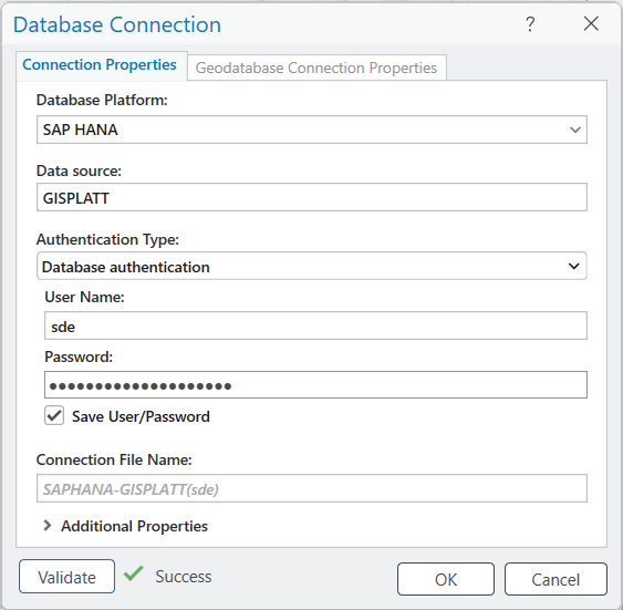
The new connection file appears in the Catalog pane under Databases.
Note: For connection details and ArcGIS Server registration guidance, see Connect to SAP HANA from ArcGIS.
Create the enterprise geodatabase
To use the Enable Enterprise Geodatabase geoprocessing tool in ArcGIS Pro to create the geodatabase in SAP HANA, you must provide the following:
- The sde database connection file you created earlier (.sde)
- The ArcGIS Server keycodes authorization file
The tool creates the geodatabase system tables, views, functions, and procedures in SAP HANA.
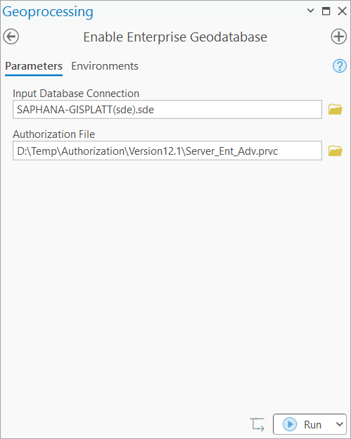
Note: The Create Enterprise Geodatabase tool is not supported with this database type.
Troubleshooting tip
If geodatabase creation fails, review sde_setup.log in the directory identified by the TEMP or TMP environment variable on the machine where the tool or script ran.
You can also automate this workflow with ArcPy by creating a temporary connection file, running the Enable Enterprise Geodatabase tool, and then removing the temporary file.
import arcpy, os, sys, tempfile
if len(sys.argv) != 3:
print (“usage: enable_gdb.py database_dsn sde_pwd”)
sys.exit(3)path = tempfile.gettempdir()
if os.path.exists(path + r’\enable_gdb.sde’):
os.remove(path + r’\enable_gdb.sde’)arcpy.management.CreateDatabaseConnection(
path ,r’enable_gdb.sde’, ‘SAP HANA’,
sys.argv[1],
‘DATABASE_AUTH’,
‘sde’,sys.argv[2],
‘SAVE_USERNAME’
)arcpy.management.EnableEnterpriseGeodatabase(
path + r’\enable_gdb.sde’,
r”\\mykeycodes\Server_Ent_Adv”)if os.path.exists(path + r’\enable_gdb.sde’):
os.remove(path + r’\enable_gdb.sde’)sys.exit(0)
Note: For the current Python sample and parameters, see Create a geodatabase in SAP HANA.
Verify the geodatabase deployment
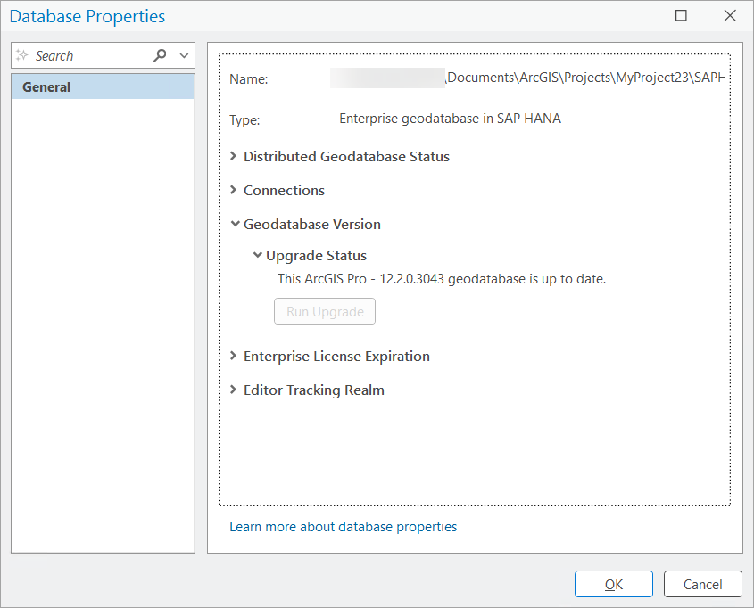
After enabling the geodatabase, verify core functionality first and then move into routine administration practices. To verify the deployment, complete the following steps:
- Right-click the geodatabase administrator database connection and select Properties.
- Review the General tab of the Database Properties pane for properties such as Type and Geodatabase Version.
Geodatabase management
The geodatabase is not a stand-alone component. It operates as part of an integrated SAP HANA and ArcGIS system, so database platform health, client compatibility, and connection management must all work together.
As a common operational practice, use the database administration tools to monitor database health and capacity, maintain tested backups, and coordinate maintenance windows that may affect user connections.
Use ArcGIS geodatabase administration tools to review connections and, when needed, block new connections or disconnect users before performing a geodatabase maintenance operation.
Note: Review administration workflows in Manage an enterprise geodatabase.
Manage users and dataset access
Now that the geodatabase is in place, set up separate user accounts and give each user the access they need to do their work.
Before loading production data, test a connection with a data owner login and confirm that intended ArcGIS Pro and ArcGIS Enterprise clients can connect using a supported SAP HANA client.
Note: It is important to not load data as the sde user and keep this login reserved for geodatabase administration tasks.
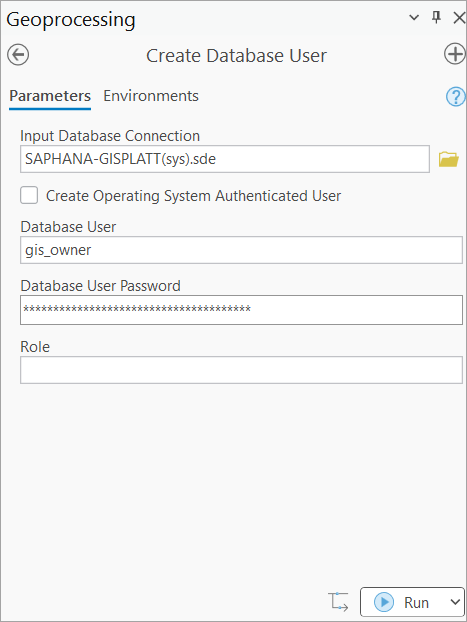
You can create a standard database user using either the database tools or in ArcGIS Pro using the Create Database User geoprocessing tool. By default, this tool creates a standard user that can create data in their own schema and read system tables.
Once your geodatabase and users are in place, you can create new datasets or register existing data with the geodatabase. From there, you can use enterprise geodatabase capabilities such as relationship classes, subtypes and attribute domains, editor tracking, nonversioned archiving, branch versioning for long transaction workflows, and topology for branch versioned data published as a web feature layer.
Next, assign database user privileges according to job responsibilities.
As the database administrator, use SQL or SAP HANA tools to grant and revoke users access to the instance, the database, or privileges on SAP HANA system metadata tables.
As the data owner, use ArcGIS to grant or revoke privileges on geodatabase datasets. Use the Change Privileges geoprocessing tool to grant or revoke view or edit access on datasets, feature classes, and tables to other users.
Note: Review the SAP HANA Security Guide on Object Privileges for more information on granting privileges on database objects.
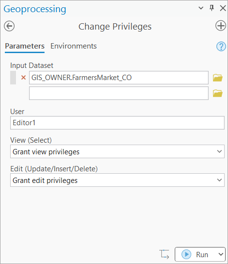
The following table shows the main user types and their respective responsibilities:
User type |
Recommended responsibilities |
| Geodatabase administrator | The sde user owns and manages geodatabase system objects and the default geodatabase version. |
| Data owner | A user creates and owns feature classes, tables, and other business datasets. |
| Data editor | A user who has been granted read or write privileges on data stored in the geodatabase. |
| Data viewer |
A user who has been granted read privileges on data stored in the geodatabase. |
Note: For the authoritative privilege matrix, including application-lock privileges and temporary privileges required during upgrades, see Privileges for geodatabases in SAP HANA.
Upgrade a geodatabase in SAP HANA
Upgrade planning should include the SAP HANA database, SAP HANA client, ArcGIS clients, geodatabase, custom applications, and published services. Before upgrading the production environment, test the full combination in a nonproduction setting, verify a recoverable backup, stop edits, remove active connections, and ensure the sde user has the documented temporary schema privileges required for upgrade.
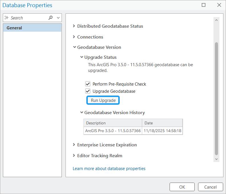
Geodatabase upgrade checklist
Use the following checklist to prepare for and initiate upgrading:
- Review current ArcGIS requirements for the target SAP HANA version and confirm client and geodatabase compatibility.
- Confirm the geodatabase is eligible for upgrade through the Database Properties pane in ArcGIS Pro.
- Backup the database and verify the recovery procedure.
- Temporarily grant the sde user the documented privileges on every schema containing data registered with the geodatabase.
- Run the Upgrade Geodatabase tool with the prerequisite check enabled.
- Validate dependent applications and services, and revoke temporary elevated privileges.
Note: Follow the complete procedure in Upgrade a geodatabase in SAP HANA.
SAP HANA considerations
Apply SAP HANA naming and data type rules early in schema design to avoid compatibility issues later in ArcGIS workflows.
Names and identifiers
Use database object names that comply with SAP HANA and ArcGIS naming rules. Avoid designs that depend on quoted identifiers or case-sensitive delimiters and verify the documented length and character restrictions before creating production schemas and datasets.
Note: See Enterprise geodatabase size and name limits for more information.
Data types
ArcGIS connects the supported SAP HANA data types to ArcGIS field types. Columns that use unsupported data types are not exposed in ArcGIS. Review the current mapping before designing tables, views, query layers, or data-loading processes.
Note: See SAP HANA data types supported in ArcGIS for more information.
A successful geodatabase deployment in SAP HANA depends on coordinated administration across the database, ArcGIS, and client components. Therefore, it is important you establish the right users and privileges, validate connectivity, and follow tested management and upgrade practices to run a secure, maintainable, and production-ready enterprise geodatabase.
Additional resources
See the following for more information:
- Introduction to enterprise geodatabases in SAP HANA
- Create a geodatabase in SAP HANA
- Geodatabase administrator in SAP HANA
- Privileges for geodatabases in SAP HANA
- Connect to SAP HANA from ArcGIS
- ArcGIS requirements for using SAP HANA
- Upgrade a geodatabase in SAP HANA
For more geodatabase management related content, check out the Geodatabase Resources Hub.






Commenting is not enabled for this article.