For decades, computers have struggled with a surprisingly human question:
What is a place like?
Ask a person about their neighborhood, and the answer comes naturally. They might describe it as a quiet suburb with good schools. A vibrant college town. An affordable community with a strong sense of local identity. A dense urban district filled with restaurants and public transit.
We humans rarely think about places in terms of individual variables. We think about them in terms of character.
Machines, on the other hand, have traditionally needed a spreadsheet. To understand a place, they needed rows and columns of demographic variables, housing statistics, income measures, environmental indicators, and countless other datasets. The more complete the understanding, the longer the list became.
For years, this has been one of the fundamental challenges of geospatial analysis: before you can answer a question about a place, you first must describe it.
But what if machines could learn the character of a place for themselves?
That question is giving rise to a relatively new class of AI systems: location-encoder models, which are types of geospatial foundation models that learn to distil data about a location into a representation of the place. And they may fundamentally change how machines understand the world around us.
The idea that changed AI
Many of the breakthroughs we associate with modern AI share a common idea:
Representation learning.
Instead of asking humans to manually engineer features, models learn useful representations of data directly from the data itself.
Language models learn representations of words and sentences. Vision models learn representations of images. Recommendation systems learn representations of users, products, and preferences.
These learned representations—often called embeddings—are compact numerical encodings that capture patterns which would be difficult to describe manually. Think of how you instantly recognize a friend’s voice from a few syllables, without being able to articulate exactly which acoustic features give it away. Embeddings perform an analogous compression for machines: the model learns what matters and encodes it, even when no human can fully explain the rules.
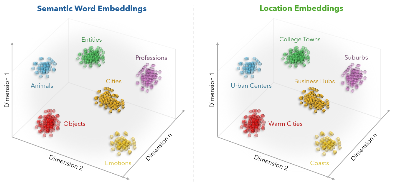
Take language models as an example. When one encounters the word “car”, it doesn’t process a sequence of letters. It maps the word into a numerical space where meaning and relationships are encoded by position. That is why language models know that “sedan” and “car” are closely related while “sedan” and “ocean” are not.
The model learns a representation of language. But language isn’t the only thing that contains structure.
Locations do too.
Location is more than coordinates
At first glance, location seems simple. Every place has a latitude and longitude. But anyone who has worked with geographic data knows that coordinates tell only a small part of the story.
Two locations can sit just a few miles apart and have entirely different demographic, economic, and environmental characteristics. Conversely, two places separated by thousands of miles may share surprisingly similar traits. A college town in Arizona may have more in common with a college town in Indiana than with nearby communities. A rapidly growing suburb in Oregon may closely resemble one in New Jersey despite sitting on opposite sides of the country.
The challenge is that these similarities emerge from the interaction of many factors—income, housing, education, age, land use, climate, population density, and countless others. No single variable tells the whole story. The character of a place emerges from all of them together.
That makes location an ideal candidate for representation learning.
What if places had fingerprints?
Imagine taking thousands of location variables and compressing them into a compact representation that captures the broader context of a place—not a replacement for the original data, but a summary of the patterns hidden within it.
A fingerprint.
Places with similar characteristics would have similar fingerprints. Places with different characteristics would have different ones.
Comparing locations suddenly becomes much less about selecting the right variables and much more about comparing geographic context encoded in these fingerprints. What emerges is a different way of thinking about distance—not geographic distance, but contextual distance. The number of miles between two places matters. But so does the similarity of the underlying geographic context that defines them.
This is the idea behind location embeddings. Just as language embeddings capture the meaning of words, location embeddings capture the character of places. And once places can be represented as embeddings, entirely new possibilities emerge.
Esri’s approach to location foundation models
Recognizing this opportunity, Esri has been developing foundation models that learn location context directly from data.
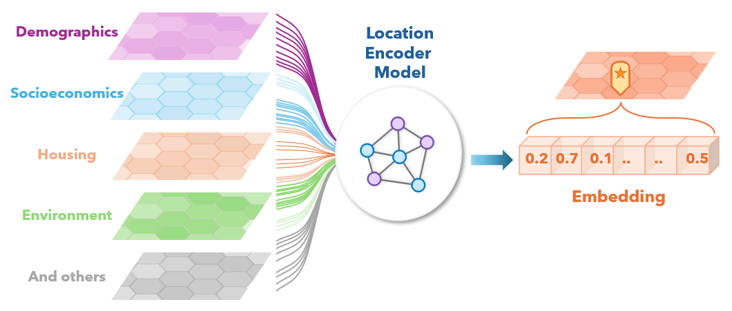
One result is the Geodemographic Foundation Model (GDFM). It draws on four complementary datasets: long-term demographic patterns from the U.S. Census, recent socioeconomic conditions from the American Community Survey, housing and household characteristics, and environmental data covering temperature, precipitation, land cover, and so on. Together, these contribute more than 5,000 variables describing every location.
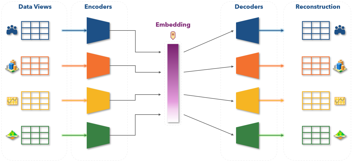
At the heart of GDFM is a multiview autoencoder. Each of the datasets is fed into its own dedicated encoder network, which compresses thousands of variables into a compact intermediate representation. Those representations are then passed through individual decoders for each dataset, which attempt to reconstruct the original inputs. By training the model to minimize reconstruction error across all views simultaneously, GDFM learns the unique patterns from them—the underlying character of a place, rather than noise in any single dataset.
The output is a 256-dimensional vector for every location—a single, compact representation that encodes demographic structure, socioeconomic conditions, housing characteristics, and environmental context all at once. That is the fingerprint.
The goal mirrors that of modern foundation models in language and vision: learn a rich representation once, then adapt it across many downstream applications.
Using GDFM, Esri generated the USA Geodemographic Embeddings—a nationwide set of location embeddings covering the contiguous United States, Hawaii, and Alaska at the Uber H3 resolution 7 hex-bin geometry. Each embedding represents the broader context of a location while preserving relationships between places that share similar characteristics.
In effect, GDFM is learning fingerprints of places.
From representations to real-world GIS workflows
The true value of a representation is in what it enables. Once places can be expressed as embeddings, familiar geospatial workflows begin to look very different.
Finding similar places becomes a nearest-neighbor search in the ‘embedding space’. Clustering communities becomes a pattern recognition problem. Enriching predictive models with geographic context becomes significantly easier. And crucially, the same underlying representation supports all three—a planner searching for communities that resemble a target neighborhood, a data scientist enriching a price-prediction model with spatial context, and a researcher identifying groups of distant locations that share common characteristics are all working from the same foundation.
Through ArcGIS Living Atlas of the World, Esri is making USA Geodemographic Embeddings available directly inside GIS workflows. Rather than building custom representations for every project, analysts can plug these embeddings into similarity search, clustering, and predictive modeling using tools they already know.
This represents a meaningful shift: from working with long lists of variables to working with learned location representations—the same kind of shift that embeddings brought to natural language processing more than a decade ago, and which now explains much of how machines understand text.
A new chapter for location intelligent AI
For years, AI learned to understand language. Then images. Then code. Now it is beginning to learn something equally important:
Place.
Not as coordinates. Not as administrative boundaries. Not as thousands of disconnected variables. But as context, as relationships, as patterns—as characteristics of a place.
The idea that every place has a fingerprint may sound abstract. Yet a decade ago, the idea that every word or image could be represented as an embedding sounded abstract too. Now it underpins much of modern AI.
Location intelligence may be next. And if that happens, the most important question may no longer be where things are—but how well machines can understand what places are truly like.



Article Discussion: