Modern stormwater systems include a mix of gray and green infrastructure. As the name implies, gray infrastructure is generally composed of man-made materials such as concrete or metal and includes pipes, culverts, and catch basins. Green infrastructure is primarily made up of natural materials—plants, organic materials, dirt, rocks—and may also incorporate natural features like streams and wetlands. Examples of green infrastructure include green roofs, rain gardens, and bioswales. The use of green infrastructure has increased in recent years, largely because green infrastructure often has better environmental and social benefits and a lower total cost of ownership than gray infrastructure.
Green infrastructure can be found on both public and private land, which means that stormwater organizations are not always responsible for maintenance. However, in addition to digitally recording inspections conducted by their own organization, stormwater organizations must also collect and retain the inspection and maintenance records of green infrastructure collected on private lands.
Streamlining the assignment of inspection activities and improving inspection program management supports program compliance and reporting efforts.
The Green Infrastructure Inspections solution helps with this process by delivering a set of capabilities that help stormwater managers assign inspections, record inspections in the field, monitor inspection activities, and manage private green infrastructure maintenance activities.
Inspect green infrastructure
Stormwater inspectors regularly conduct inspections of green infrastructure assets in their communities. These inspections are essential because they help ensure the effectiveness of these assets. They also provide an opportunity for inspectors to address issues of assets on public lands.
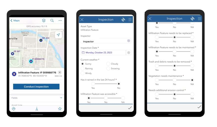
Using ArcGIS Field Maps and an ArcGIS Survey123 form, included with the solution, stormwater inspectors can quickly conduct site inspections in the field. The form is preconfigured so that inspectors can easily collect inspection information and capture photos onsite.
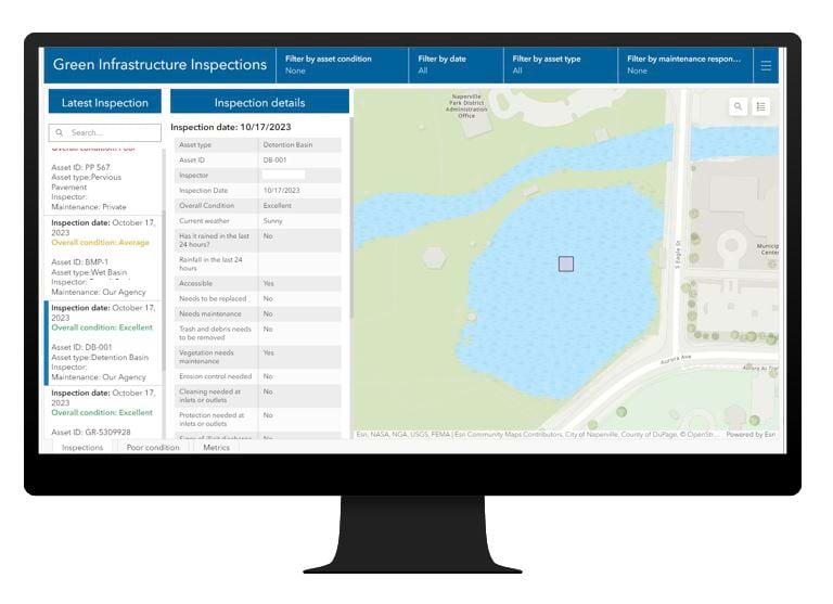
After stormwater inspectors submit their inspections from the field, stormwater managers have immediate access to inspection details through the Green Infrastructure Inspections dashboard. From the dashboard, stormwater managers can monitor asset conditions and gain additional insight into any assets that are in poor condition by visualizing the condition history. Managers can also review metrics about the green infrastructure assets of an entire community, which helps them distinguish between assets on public versus privately owned land.
Review condition assessments
Although stormwater managers are not responsible for maintenance of green infrastructure assets on private land, they may have reporting and enforcement responsibilities to ensure that the green infrastructure assets on private property are functioning correctly. Green Infrastructure Inspections deploys with an ArcGIS Hub site which, when shared with the public, can be used to manage private property owners who are responsible for reporting on green infrastructure.
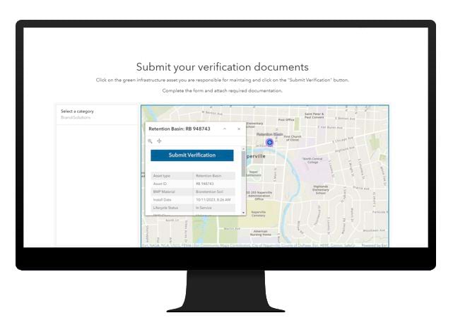
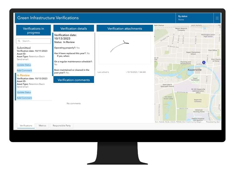
A private property owner can create a community account and, after signing in, request permission to submit asset condition and maintenance reports online. The Green Infrastructure Verifications dashboard helps stormwater managers manage these applications, allowing managers to review the application contact information as well as any supporting documentation provided.
Once a private property owner has been approved and assigned to an asset, an automated process sends the user an email with sign-in instructions and a link to the Green Infrastructure website. After signing in, the user will see only those assets they are assigned to. For each asset, the user will complete the online inspection form and upload any required supporting documentation and photos, and then they can submit the information. The information is immediately available to stormwater managers in the Green Infrastructure Verifications dashboard. The managers can review the information, add comments, and update the submission status.
Learn More
For more information about the Green Infrastructure Inspections solution, check out the following resources:
- Learn how to deploy, configure, and use the solution.
- View a demo video.
- Chat with us on Esri Community or contact Esri Support Services.
- Learn more about ArcGIS Solutions.


Article Discussion: