Do you manage, inspect, or maintain stormwater assets? If so, ArcGIS Solutions has been working hard to make your life easier. If you’re ready to jump start your digital workflows, keep reading more to find out how.
Wherever rain falls, it creates stormwater. Stormwater must go somewhere, whether it seeps into the ground, or a pipe moves it to the nearest river. Sometimes, a slow drizzle leaves the land damp with no major issues. However, larger storm events are leaving roads unpassable, a problem that could be due to flooding or even a clogged storm drain.
Still waters run deep
Effective stormwater management is critical for both economic and safety reasons. When is handled efficiently, it limits erosion and soil loss, prevents sewer system overflows, and reduces flood risk. Perhaps more importantly, it protects infrastructure, safeguards animal habitats and human life, and leads to a cleaner and safer water supply. But the general population doesn’t always understand stormwater as a critical infrastructure in the same way they appreciate other utilities or infrastructure. If people notice stormwater, it likely means that something has gone wrong. Which brings us back to effective stormwater management through digital transformation.

Keep your head above water
ArcGIS Solutions has a full complement of stormwater solutions designed to streamline your stormwater management processes. Some focus on supporting the unique needs of the Phase II MS4 permit requirements, but even if you are not under the MS4 requirements, you probably have similar needs. Regardless, anyone who is an Esri customer, can instantly deploy these solutions to their organization or platform. Here’s how you can put our stormwater solutions to work for you:
Stormwater Data Management
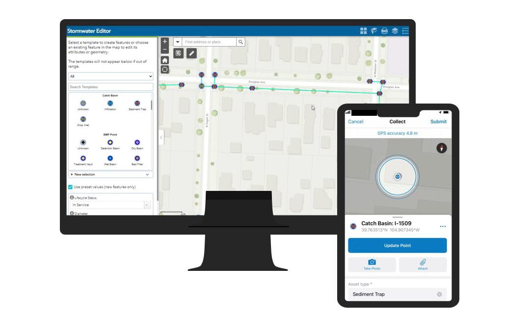
A complete inventory of stormwater assets helps you streamline inspections, maintain assets, and monitor your regulatory compliance. But creating and maintaining an inventory takes a lot of time and requires a GIS professional, doesn’t it? Not with our Stormwater Data Management solution. Designed to save you time, this solution delivers a set of capabilities that helps your organization map stormwater systems, edit data, view system maps in both the field and the office, view asset reports, and collaborate with map notes.
With a click of a button, you will have an entire stormwater system schema that includes pipes, catch basins, manholes, channels, and more. Each asset type also includes fields to store important information that you need about the asset. When appropriate you can store diameters, invert elevations, material, downstream elevations, and much more. Many of the field have pick lists (domains) already; for example, pipe material has 26 types to choose from.
Don’t know how to make a pretty map? No problem! The solution comes with maps that you can use to edit your data. And you can quickly make your system data available to everyone in your organization by sharing a view-only map, also included with the solution.
Catch Basin and Outlet Inspections
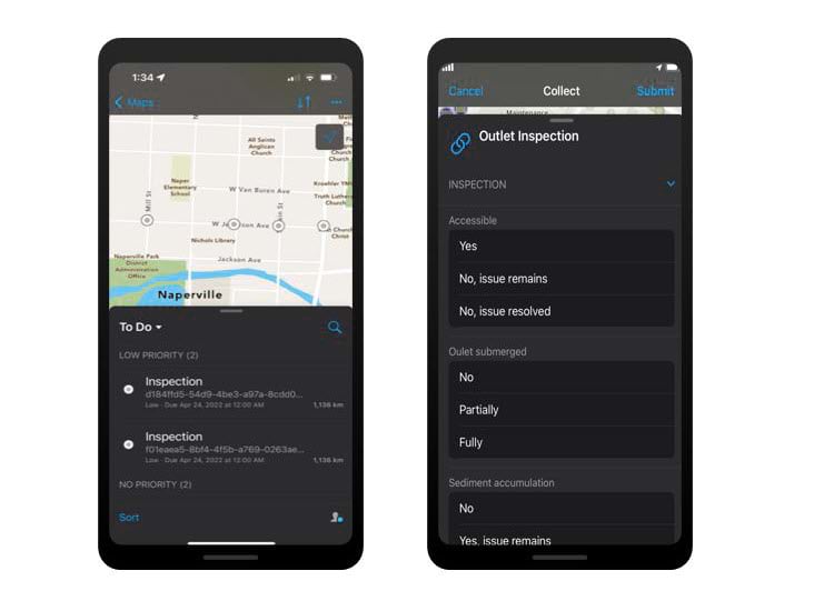
When it comes to catch basin and outlet inspections, both quality and quantity matter; routine inspections ensure both system reliability and high water quality. Deploying the Catch Basin and Outlet Inspections solution means access to capabilities that help stormwater managers conduct routine catch basin and outlet inspections, understand asset conditions, record inspections in the field, manage inspection activities, and ensure that the entire organization has access to inspection information.
Are you ready to move from a paper workflow to a digital one? This solution makes the transition a smooth one. We have worked with many stormwater managers to create an inspection form that works for both catch basins and outlets. Start digitally inspecting your outfalls today!
Green Infrastructure Inspections
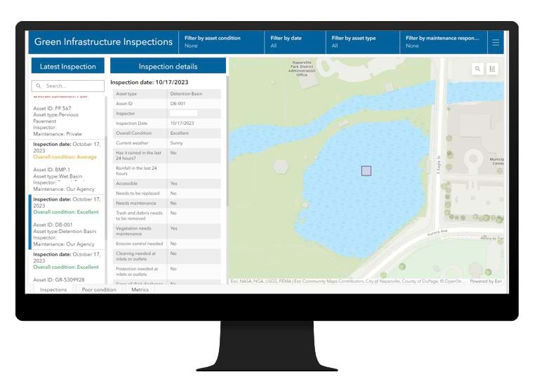
It’s not easy bein’ green, but our Green Infrastructure Inspections solution can definitely help. The capabilities deployed with this solution help stormwater managers assign and manage inspections as well as facilitate the collection and review of private green infrastructure maintenance activities. It also supports stormwater inspectors who must record inspections while in the field.
There is no need to manage your private property owner list in a spreadsheet anymore. With this solution you can invite owners to sign up and apply through an online portal. Then you can start accepting private property owner maintenance information digitally.
Inspections can be conducted quickly with a simplified digital form, so stop maintaining all those individual paper asset inspection forms and go mobile.
Stormwater Construction Activity Management
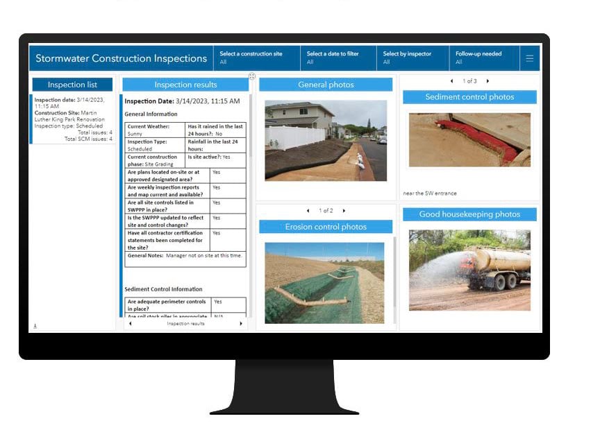
Inspecting construction sites for stormwater compliance can be tricky. Fortunately, you don’t need to control weather to successfully conduct routine site inspections. You just need to deploy the Stormwater Construction Activity Management solution. This stand-alone ArcGIS Online solution delivers capabilities that help stormwater managers assign and manage regular inspections, understand effectiveness of stormwater control measures on a site, and observe sediment and erosion control on construction sites. Additional capabilities help fieldworkers record inspections and provide actionable reports while still in the field.
Do you spend more time driving than you do on site? With apps included in the solution, you (or your inspectors) can conduct inspections and provide site operators with reports, all without once leaving the site. Complete the inspection form, add notes, and take as many photos as you need. You can even caption your photos and attach them to the inspection without adding them to the official report. Now that’s efficiency at its finest!
Coming soon: Stormwater Outreach
Currently under development, the Stormwater Outreach solution will deliver a set of capabilities that help stormwater managers conduct public education and outreach, allow the public to report water quality issues, provide a framework for stormwater personnel to triage reported issues, and manage and communicate with volunteers and program stakeholders.
Smooth(ish) water
No, stormwater management is not always smooth. But it is important and valuable work. ArcGIS Solutions is proud to offer you a collection of solutions that may smooth out at least some of the turbulence. Why not dip your toe in the water and see if these solutions work for you?
Learn more
For more information about our stormwater solutions, check out the following resources:
- Stormwater Data Management
- Deploy, configure and use the solution.
- View a demo video.
- Catch Basin and Outlet Inspections
- Deploy, configure and use the solution.
- View a demo video.
- Green Infrastructure Inspections
- Deploy, configure and use the solution.
- View a demo video.
- Stormwater Construction Activity Management
- Deploy, configure and use the solution.
- View a demo video.
- Learn more about ArcGIS Solutions.


Article Discussion: