The 2023 Esri User Conference is quickly approaching, and the 3D team is looking forward to greeting our user community in beautiful San Diego, July 10-14. We’ve prepared an amazing lineup of sessions and activities designed with everyone in mind, whether you’re new to ArcGIS or an experienced GIS professional. From our visionary plenary session, success stories from users and partners, or presentations from Esri’s technology and industry experts, we will showcase how 3D and digital twins can play a role in creating the world you want to see.
Please keep reading to find a recommended list of sessions that provide an overview of 3D GIS, a deeper dive into tools and workflows that align with our 3D pillars, and a view into how ArcGIS 3D capabilities create a foundation for living digital twins. For a full list of 3D and digital twin sessions and activities, check out our UC Flier.

ArcGIS Pro: Getting Started with 3D
Learn how to get started with 3D GIS; it’s much easier than you think. This session will cover 3D data types, applying Z values to existing data, building 3D data from scratch, and working with elevation values. With an understanding of how to work with 3D data, you will also learn considerations around Local vs. Global scenes.
Add it to your schedule: Tuesday, Jul 11 | 1:00 PM – 2:00 PM PDT (4:00 PM – 5:00 PM EDT)
ArcGIS: An Overview and the Road Ahead for 3D
Esri has an expanding range of 3D capabilities that can be used on the web, desktop, and mobile. This session will cover core technology improvements in ArcGIS Pro and Scene Viewer and the configurable apps that utilize web scenes. This session will provide a foundation to discuss emergent patterns of 3D imagery collection and utilization, data management, visualization, and analysis capabilities. You’ll gain a deeper understanding of the roadmap and strategy approaching 3D GIS and practical advice for implementing performant and valuable GIS experiences.
Add it to your schedule: Tuesday, Jul 11 | 2:30 PM – 3:30 PM PDT
ArcGIS Pro: Tips and Tricks
Whether you are just getting started with ArcGIS Pro or have used it for years, there is always something new to discover. Learn crafty tips and wily tricks to boost productivity and efficiency when completing your work in ArcGIS Pro. Areas covered will include mapping, data and content management, analysis, sharing… and speaking of sharing, we’ll be sure to leave time for you to share your favorite ArcGIS Pro tips!
Add it to your schedule: Wednesday, Jul 12 | 8:30 AM – 9:30 AM PDT & Friday, Jul 14 | 9:00 AM – 10:00 AM PDT

ArcGIS: Create and Manage 3D Content
Learn how to create and maintain different types of 3D content like building, BIM models, and other 3D layers in ArcGIS. The session will cover different workflows for editing 3D web layers and updating existing 3D content.
Add it to your schedule: Wednesday, Jul 12 | 11:30 AM – 12:15 PM PDT
Living Atlas: An Introduction to OpenStreetMap Content
OpenStreetMap (OSM) is an open, editable map of the world maintained by a global community of contributors. In this session, you will learn how you can access OSM data in ArcGIS via Esri-hosted services, including customizable basemaps, live feature layers, and new 3D basemaps. Learn how to use OSM data in your work and share your authoritative GIS data (e.g., buildings, addresses, places) to help make OSM better for everyone.
Add it to your schedule: Wednesday, Jul 12 | 4:00 PM – 5:00 PM PDT
ArcGIS CityEngine: Procedural 3D Content with ArcGIS
ArcGIS CityEngine is an advanced modeling software that can be used with other tools to enhance 3D workflows. This session will provide an overview of how to leverage the power of Twinmotion, Game Engines, and NVIDIA Omniverse and how to take advantage of CityEngine Plugins as well as PyPRT, a Python binding for CityEngine Procedural Runtime.
Add it to your schedule: Thursday, Jul 13 | 1:00 PM – 1:45 PM PDT

ArcGIS Earth: An Introduction
ArcGIS Earth provides a no-cost, lightweight, easy-to-use interface for an immersive 3D experience that complements ArcGIS Pro’s and Scene Viewer’s capabilities. Explore geospatial data with experiences tailored for professional and entry GIS users. Consume, discover, analyze, and share geospatial 3D data on the globe.
Add it to your schedule: Tuesday, Jul 11 | 8:30 AM – 9:30 AM PDT
ArcGIS Scene Viewer: Authoring Web Scenes
Discover the authoring capabilities of Scene Viewer and learn how to leverage 2D and 3D content to build stunning 3D web applications. This session will cover the fundamentals of authoring web scenes, the type of scene layers, and how to use them as a base for your tailored web application. Driven by data in 2D and 3D and no coding required.
Add it to your schedule: Tuesday, Jul 11 | 10:00 AM – 10:45 AM PDT
ArcGIS Pro: 3D Visualization with Procedural Symbology
This session will cover the use of procedural symbology in ArcGIS Pro and the benefits of quickly rendering data with more realistic detail. The focus will be on importing and using rule packages in Pro and the power of authoring rule packages with CGA from CityEngine.
Add it to your schedule: Thursday, Jul 13 | 11:30 AM – 12:15 PM PDT
ArcGIS Scene Viewer: An Introduction
Scene Viewer is Esri’s flagship experience for 3D web GIS. In this session, we will show how you can leverage your 3D GIS data by making it accessible through Scene Viewer and web apps. We will take an in-depth look at authoring web scenes and using capabilities to create exciting and intuitive experiences with the latest updates. We will show you how to create configurable 3D GIS applications with StoryMaps, Experience Builder, and Instant apps. Learn about what’s new and the roadmap.
Add it to your schedule: Thursday, Jul 13 | 2:30 PM – 3:30 PM PDT

The 3D Object Feature Layer
Learn how to create, modify and import 3D object feature layers with dedicated file formats such as GLTF, GLB, FBX, OBJ, DAE, and DWG. Using ArcGIS Pro, you will learn how to modify or create unique 3D geometry shapes such as Slicing or adding Textures directly into the geometry. Learn how to interact with 3D-Object Feature Layer data for visualization and analysis, and understand how to use this vital component of the 3D System of Record.
Add this to your schedule: Tuesday, Jul 11 | 11:30 AM – 12:15 PM PDT
ArcGIS 3D Analyst: LiDAR and Integrated Mesh
This workshop will cover workflows and best practices on integrating lidar and integrated mesh data into your desktop and online 3D web scenes, including using the point cloud and integrated mesh I3S scene layer formats. This session will cover data acquisition, feature extraction, processing, and publishing. It will include steps for classifying lidar using a rule-based technique and newer approaches using deep learning. Plus, it will discuss how lidar and 3D mesh from multiple sources can add value to your 3D GIS workflows.
Add this to your schedule: Wednesday, Jul 12 | 10:00 AM – 11:00 AM PDT
ArcGIS 3D Analyst: An Introduction to Surface Analysis
An overview of the TIN, Terrain dataset, LAS dataset, and raster surfaces that can be created with the 3D Analyst extension and the analysis operations that can be achieved with those surfaces. Workflows showcasing how to edit surfaces and derive analysis results that utilize surface area & volume calculations, slope, contour, and aspect values will be highlighted, along with using surfaces in creating immersive scenes.
Add this to your schedule: Wednesday, Jul 12 | 1:00 PM – 2:00 PM PDT

ArcGIS Maps SDKs for Game Engines: What’s New and Road Ahead
Join the ArcGIS Maps SDKs for Game Engines development team to learn about what’s new and coming next in the ArcGIS Maps SDKs for Game Engines.
Add it to your schedule: Tuesday, Jul 11 | 1:00 PM – 2:00 PM PDT
ArcGIS Urban: Implementing VR for Immersive Collaborative Urban Planning
With advances in graphics hardware and software, game engine technology is being applied in numerous domains, including GIS, to provide users with immersive, interactive, and visually compelling experiences to explore data. In this session, the presenters will discuss workflows for consuming content from ArcGIS Urban into Virtual Reality (VR) to explore and share urban plans and BIMs through interactive experiences.
Add it to your schedule: Wednesday, Jul 12 | 2:30 PM – 3:15 PM PDT
ArcGIS: Extended Reality(XR)
Attend this session to get an overview of Esri’s vision of how extended reality applies to GIS. We’ll discuss how Esri technology can power augmented reality (AR) and virtual reality (VR) experiences across various industries. We’ll also demonstrate how GIS data can be used with Unity and Unreal Engine game engines to create immersive AR/VR experiences on mobile devices and headsets such as Magic Leap 2 and Varjo XR-3.
Add it to your schedule: Wednesday, Jul 12 | 2:30 PM – 3:30 PM PDT

Telecommunications: Digital Twin
Digital twins are supporting the end-to-end build-out of broadband networks, from planning, to construction, to as-built. The ArcGIS system is the foundation of any digital twin, and in this session, you’ll hear from two telecommunications companies as they share how their organizations are leveraging ArcGIS to model all phases of their fiber and wireless network rollout.
Add this to your schedule: Tuesday, Jul 11 | 1:00 PM – 2:00 PM PDT
Geodesign and Digital Twins: The Road Ahead
More than ever, GIS technology is transforming how we design and plan our communities, regions, and the world. This digital transformation of traditional planning has given rise to a new and exciting field – Geodesign. In addition, we also hear the term Digital Twin everywhere these days. But what are they really? And what role should GIS and Geodesign play in implementing Digital Twins? Join us in this session to learn more about the fundamentals of Geodesign and explore some examples of how ArcGIS can play a supporting role in building your next digital twin.
Add this to your schedule: Tuesday, Jul 11 | 10:00 AM – 11:00 AM PDT
Demystifying Digital Twins
A digital twin is a virtual representation of the real world, including physical objects, processes, relationships, and behaviors. GIS creates digital twins of the natural and built environments and uniquely integrates many types of digital models. The convergence of geospatial technology, building information modeling (BIM), and interactive 3D has driven a conversation about “Digital Twins” and how they may be used to simulate single facilities, entire cities, and even large natural systems.
Add this to your schedule: Saturday, Jul 8 | 8:30 AM – 9:30 AM PDT

We value your insights! Take a moment to share your 3D experience with us. We’re eager to hear how 3D is helping you tackle your unique GIS challenges. Your input on the ArcGIS products you use is highly appreciated and will help us create better user experiences. Let your voice be heard; take our annual 3D survey now.

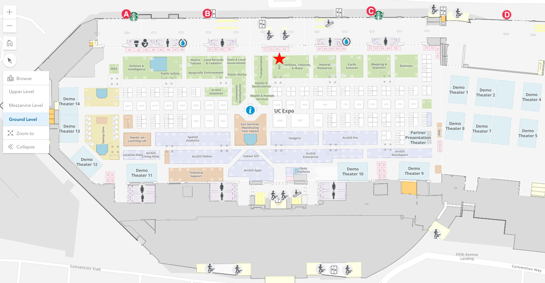
Meet the 3D and Digital Twin team at the AEC Showcase on the Ground Level Exhibit Hall A of the San Diego Convention Center. Our location is marked with a star on the map below. We’ll be there from 9:00 AM – 6:00 PM on Tuesday, July 11 to Wednesday, July 12, and 9:00 AM – 4:00 PM on Thursday, July 13.
To help you navigate UC and the San Diego Convention Center, access the new UC Map. Use this map to generate directions and the estimated arrival time when navigating from one session location to the next. In addition, don’t forget to check out the Detailed Agenda and My Schedule, to plan your UC experience. The UC Map will also be available in the Esri Events App to help you navigate on the go and at directory kiosks on-site in the convention center. Learn more about mapping the Esri UC here.
About the authors

Cliff Song


Article Discussion: