The June 2023 release of ArcGIS Business Analyst Web App contains major updates to U.S. demographic content, including data from the 2020 U.S. Census and 2017-2021 American Community Survey (ACS) variables.
Last June, I wrote this article explaining why all previously created standard geography sites in the U.S. had to be recreated because of significant changes in the underlying Census boundaries: Recreate your standard geography sites in Business Analyst using the Esri 2022 data source.
Unlike last time, the standard geography sites you created with the U.S. 2022 data will work seamlessly with the updated 2023 data in most cases. However, there are four levels of geography that will need to be recreated because the boundaries and content have changed. This article will walk you through these changes.
Access different vintages of data in the United States
By default, when you log in to Business Analyst and you are using data in the United States, the application is set to use the most recently available content. You can use the country switcher in the application to access data from 2021, 2022, and 2023:

How do I use my geographic sites?
When using the 2023 data, most standard geography sites you created with the 2022 data will still be available. Specifically, if you previously created standard geography sites for these levels, they will automatically be mapped with the most recent data:
- United States (whole country)
- States
- Counties
- County Subdivisions
- Core Based Statistical Areas (CBSAs)
- Census Tracts
- Block Groups
For example, I have a set of counties that I previously created in 2022 to perform analysis in the southwestern United States. When I switch between accessing the 2023 and 2022 U.S. data sources, these counties are still available.

What boundaries have changed with the 2023 data?
There are some significant changes in four standard geography levels with the release of the U.S 2023 data:
- Census Places (Cities and Towns)
- Congressional Districts
- Designated Marketing Areas (DMAs)
- ZIP Codes
Boundaries for these standard geography levels have changed between 2022 and 2023. Because of these boundary changes, and because of the way geographies can be merged to create custom geographic sites, they cannot be migrated across different data sources and geographic boundaries. You’ll need to recreate these geographies in the new data source.
How can I tell if I have standard geography sites that have changed?
If you have saved standard geography sites for these four levels, you will see a warning message like this in the project pane:

Let’s dig into what this means in practice. I previously created a project in Business Analyst Web App that contained my congressional district in the Esri 2022 data source:

As long as I am working in the Esri 2022 data source, I can continue to work with this geography-based site to create reports, infographics, and run analyses. However, if I switch to the latest Esri 2023 data source using the country switcher, I see that “No data” is listed under this folder, where I’d expected to see my geography sites:

To be clear, this standard geography site is not gone – I just need to switch back to the Esri 2022 data source to access the congressional district I created. Because this congressional district was based on a different vintage of data, its borders are incompatible with the new boundaries contained in the Esri 2023 data source.
To use Congressional Districts, DMAs, Place and ZIP Codes as sites in the Esri 2023 data source, I need to recreate them using the latest boundaries, capturing the most up-to-date demographic and geographic information available.
How do I recreate my standard geography sites in the new data source?
To create geography sites in the Esri 2023 data source, you can use the Select geography tool like you have previously.
Can I add my previous standard geography sites to the map as a reference?
There may be instances where you want to add previously created standard geography sites to the map to help you recreate standard geography-based sites with the new Esri 2023 data source.
On the Maps tab, start by clicking Add data and select the Web maps and layers option.

Add web maps and layers
In the Web maps and layers window, select the My content tab at the top and select the BA – Project Data folder on the left panel.
All the map layers from your project are contained in the feature service with your project name. For example, all the content for my “Garry Article” project can be added by selecting this card and clicking the Open button.

All the sites and content for this project are automatically added to the map.

Project pane
Here you can see that I’ve added the geography site with the old congressional district I previously created with the 2022 data.

Site added to map
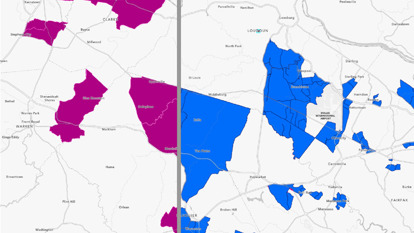
I can then select Define areas > Select geography and use the Select from map option to rebuild a similar analysis area using the Esri 2023 data source with the latest boundaries. After the congressional districts are added to the map, I select the district that corresponds to my previous site:

Selecting congressional districts
You can see the differences in the name of my congressional district and how the boundaries have changed. The green shaded area represents the area created with 2022 data, while the cross-hatched area represents my new congressional district boundary in the 2023 data.
What if I have lots of standard geography areas?
If you have lots of standard geography areas in your project, there may be too many analysis areas to add using the method described above. An alternative approach is to add the individual standard geography sites to the map that you want to migrate from the Esri 2022 data source. Then choose the option to Share results as a new ArcGIS web map. For example, I have a collection of ZIP Codes that I created with the 2022 data here:

Share as web map
Once the web map is created, you can add it to your project while using the Esri 2023 data source by clicking Add data and select the Web maps and layers option. On the My content tab, select the web map you just created to add the areas to the map. Then you can use these areas to help recreate new standard geography sites with the latest boundaries.

What if I have locally saved standard geography areas in ArcGIS Pro?
If you have created standard geography trade areas using the ArcGIS Business Analyst Pro extension, you will need to update any of the areas that were created with the Esri 2022 data source for the same levels of geography that have different boundary vintages (Congressional Districts, DMAs, Place and ZIP Codes).
Do I need to recreate point-based sites and hand-drawn sites?
One final point about migrating sites between the different vintages of U.S. data: buffer rings, drive times, and sites drawn by hand are available in Esri 2021, Esri 2022, and Esri 2023 data sources. You can add a site from a project that uses the 2022 data source, switch to 2023, and those sites will still be available.

Article Discussion: