Collector for ArcGIS didn’t just release, but as part of the ArcGIS platform, it benefits when the platform gets stronger. And June’s release of ArcGIS Online brought some cool features that you’ll benefit from when using Collector.
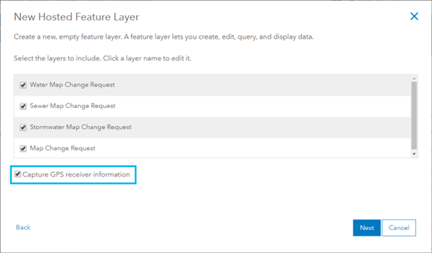
Easily include GPS metadata in layers from templates
Collector can record GPS metadata for you. With the ArcGIS Online release, layers created with the feature layer templates can include the fields required to record GPS metadata. Just check Capture GPS receiver information when using a template to create a new hosted feature layer.
New template: Ground Control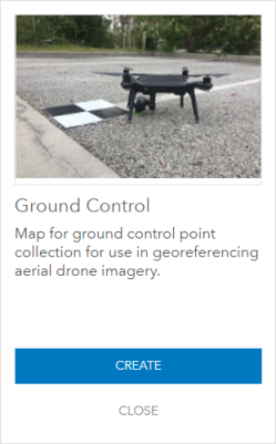
With the new Ground Control template, you can quickly create a hosted layer to store ground control points (GCPs). With your GCPs, imagery data, and Drone2Map you can create amazing imagery products with high accuracy.
Links to the Microsoft PowerBI app now work on iOS
Collector users that also use Microsoft PowerBI can now put links in pop-ups that launch PowerBi, providing access to other reporting information associated with a given asset or location. Include a link in your pop-up using the mspbi:// scheme, make sure you have the Microsoft PowerBI app installed, and you can launch it from the pop-up.
The Downside
There are also some updates that Collector won’t make use of until a later release. Arcade expressions in pop-ups are powerful, but won’t work in Collector yet. Fields that use them for the pop-up display empty on Android and iOS devices, and show <Null> on Windows devices.
In your organization, you can now enable an option Use Esri vector basemaps in supported ArcGIS apps. This changes the basemap group to use vector basemaps where they are available. Vector basemaps are not yet supported in Collector, and when enabled Collector will continue to use the existing basemap group. However, this setting does cause a couple issues for Collector. The first issue is when authoring maps for Collector. Map Viewer does support vector basemaps, so its basemap gallery uses vector basemaps. This makes it easier to create maps using vector basemaps. In Collector, the map will load but none of the vector basemap layers will display. While your users can change the basemap in Collector and continue using the map, they’ll have a better experience if the maps aren’t authored with vector basemaps. If your organization enables this setting, you need to choose your basemaps carefully when authoring for Collector to avoid vector basemaps.
The second issue caused by this setting is that it increases the chance that the default basemap of the organization is a vector basemap. Collector uses the default basemap when setting up the area for a location profile. If the default basemap is a vector basemap or contains vector basemap layers, those won’t render. Collector users will be left trying to set up the profile area without the basemap to use as a reference. Update: With the 17.0.3 release of Collector this is no longer an issue. The topographic basemap is used to set up the area for a location profile.

Commenting is not enabled for this article.