Esri is one of the leading providers of location services in the world. These location services power Esri’s own industry-leading mapping and spatial analytics products that are used by thousands of organizations around the globe. Esri recently introduced ArcGIS Platform, a location-focused platform-as-a-service (PaaS) offering that gives developers direct access to Esri’s powerful location services. ArcGIS Platform helps developers build powerful solutions with a comprehensive set of high-quality location services. You can go-to-market faster with APIs of choice – ArcGIS APIs or open source third party APIs. It also helps you stay on budget with a cost-effective developer-friendly business model – sign up for free and pay for only the additional services you use. You can build apps for web, mobile devices, desktops as well as system-to-system integration. These apps can be utilized online and offline for both indoor as well as outdoor use.
Lets take a deeper dive into each of the location services that ArcGIS Platform offers.
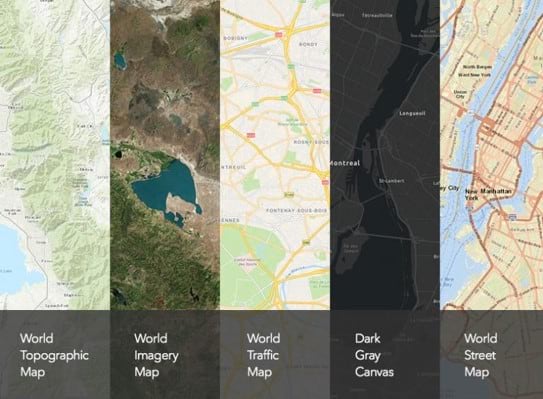
Basemaps:
Access a global collection of ready-to-use authoritative maps which you can integrate within your applications with the API of your choice and just a couple of lines of code. Basemaps provide realistic depictions of the earth at multiple scales and use authoritative data as reference sources.
ArcGIS Platform gives you access to a vast library of pre-styled basemaps for to choose from which include neutral background maps, rich foreground maps, and maps that emphasize human geography like streets or physical geography like topography. You can even find basemaps with blended elevation data, giving you the additional dimensions you need for accurate decision-making. Additionally, you can completely customize the basemaps to create your own styles. With the custom style-editor you can customize your map to select the colors, patterns, and labels that meet your unique needs.
Data hosting:
ArcGIS Platform offers you the ability to host your own data in the ArcGIS cloud. You can do more than just simply hosting a flat file in the cloud. ArcGIS Platform enables you to create services based on your data that you can visualize, edit and analyze. Data hosting with ArcGIS Platform gives you the flexibility to securely host your data in multiple file formats including spreadsheets, shapefiles or plain text files. In addition, it also give you the flexibility to choose from the API of your choice to access that data as features, vectors, image files or GeoJSON.
At Esri we truly believe in securing the privacy of your data. With ArcGIS Platform, you always retain the ownership of your data as Esri does not collect any telemetry information from your data.
Data visualization:
With data visualization capabilities you can visualize your data in truly unique ways. You can create beautiful maps to discover unique patterns and relationships. ArcGIS Platform provides tools and capabilities to create data-driven visualization in 2D as well as 3D.
You can incorporate beautiful 2D visualizations into your maps. Style your maps with thousands of features and visualizations based on multiple variables. With 3D capabilities, you can visualize the world in real-world 3D context with models of buildings, landscapes, cities or even the entire globe.
Smart-mapping capabilities help you take advantage of data-driven styling and intelligent defaults that are tailored to your data to help eliminate the guesswork while setting your map properties. Smart-mapping can be applied to both 2D and 3D data with just a few lines of code to cut down your development time.

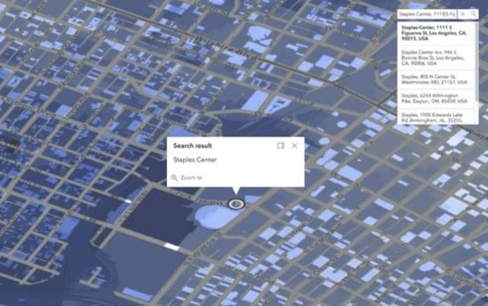
Geocoding and search:
The geocoding and search service enables you to search addresses and place names anywhere in the world and display the results on a map. ArcGIS Platform offers a complete geocoding experience. You can search a single address, or multiple addresses in a single process, or even get textual description such as nearest address, intersection, or place-name for coordinates on a map. The geocoding and search service is further enhanced by autosuggest feature that suggest multiple address candidates as you are typing in a location to search, to help you get to the right location quickly. In addition to global coverage, the geocoding and search service also offers support for local languages and address formats.
Esri’s geocoding service is powered by industry-leading reference data that comes from multiple authoritative data sources like commercial data providers, government agencies, and our network of partners around the world, ensuring you get the most accurate search results.
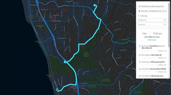
Routing and directions:
The routing and directions service help you solve complex routing problems. Many of the largest logistical companies around the globe utilize the routing and directions service to maximize logistical efficiencies and minimize costs. You can find routes, generate turn-by-turn directions and perform intelligent network analysis while applying real-world logical constraints that fit your unique needs. The routing and directions service offers global coverage with localized directions. In addition to point-to-point routing, you can also route multiple vehicles to multiple destinations to determine what stops should be serviced by each route and in what sequence the stops should be visited. This help you minimize the overall operating cost of your vehicles.
The routing and directions service helps you find the most optimized route while taking into consideration real-world constraints such as traffic feeds, U-turns, road barriers, incidents, maximum permitted vehicle height and many more. You can also perform intelligent network analysis to find best locations for your business, identify closest facilities to minimize travel costs, generate service areas to determine which locations can be reached within a given time and distance, and create origin-destination cost matrix to determine least-cost paths along the network from many origins to many destinations.
Maps and data:
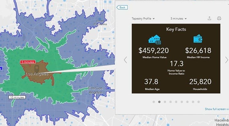
With ArcGIS Platform you get access to an extensive maps and data library. Access demographic and statistical data such as income, spending, market segmentation, and psychographic data. The GeoEnrichment service helps you analyze user-defined study areas and sites around the world for additional location-based context. This context can include data describing people, places, and businesses, with flexible output options that you can consume. You can enrich your datasets, apps, and solutions with GeoEnrichment to drive better understanding, analysis and decisions.
ArcGIS Living Atlas of the World offers the world’s foremost collection of geospatial data. Get ready-to-use curated maps and authoritative data layers, curated and prepared for easy integration within your applications. Access real-time live feeds such as traffic, current weather, and information about recent events such as flooding, wildfires, and other natural calamities. You can also access high resolution imagery from multiple data providers which includes historical collection of imagery, to visualize change over time and perform analysis.
Spatial analytics:
ArcGIS Platform also provides a comprehensive set of tools for spatial analytics. These tools help you better understand your data to reveal spatial patterns and relationships. These tools work both client-side, for highly interactive user experiences and server-side to help you scale with massive amounts of data.
By leveraging the power of your device resources, you can build highly interactive user experiences. Esri also runs analytics on the server, where the analysis tools sit right next to your data. And if you need even more analytics, you can also work with big data, real-time analytics, advanced spatial tools, machine learning, and deep learning capabilities that are already embedded in the ArcGIS system.
At Esri, we are committed to delivering the most innovative products to help you succeed. ArcGIS Platform helps you build powerful apps that make an impact. In addition to an intuitive developer experience and a comprehensive set of location services, you get a generous free tier to start your development. Take advantage of a cost-effective business model and pay for only the additional services you use.
Sign up for a free developer account on the developer’s website to get access to ArcGIS Platform.
You can also register for Esri Developer Summit Plenary Session Livestream at no-cost to see what amazing things you can do with ArcGIS Platform.
Visit the website to learn more about ArcGIS Platform.
Article Discussion: