
What’s new in Esri Demographics (June 2026)
The June 2026 release of Esri Demographics introduces expanded North American datasets, new geography levels, additional enrichment variables, and broader accessibility across ArcGIS products and workflows.
Highlights of the June 2026 release
Key updates include the following:
- New geography levels: Neighborhoods, Zip Code Tabulation Areas (ZCTAs), and Combined Statistical Areas (CSAs)
- New school enrollment variables and expanded Age by Income intervals in Esri Updated Demographics
- Expanded Census/American Community Survey (ACS) 2020–2024 variables at the block-group level
- New healthcare categories in Business Summary
- Updated Canada Advanced Demographics from Environics
- New data guides for understanding and applying data to your work
U.S. updates
New geography levels
One of the most significant enhancements in this release is the addition of three new geography levels designed to provide more flexible and meaningful ways to analyze communities and regions.
Neighborhoods
Neighborhood geography is now available for the United States.
Neighborhoods data helps users explore areas using familiar place-names and local context rather than relying solely on larger administrative boundaries.
For example: Instead of analyzing Lower Manhattan as a whole, users can explore distinct neighborhoods such as SoHo, Tribeca, and Greenwich Village.
Neighborhoods data provides a more intuitive way to understand local market characteristics, community identity, and consumer behavior.

ZIP Code Tabulation Areas (ZCTAs)
ZCTAs are now available for the United States and Puerto Rico.
Because ZCTAs remain stable throughout the Census cycle (as opposed to ZIP codes), they provide a consistent geography for comparing locations over time and supporting ZIP-level analysis, reporting, and market comparisons.
Combined Statistical Areas (CSAs)
CSAs are now available for the United States and Puerto Rico.
These geographies help users analyze broader regional relationships by combining interconnected metropolitan and micropolitan areas. CSAs reduce the need to manually aggregate smaller geographies and support regional planning, economic analysis, and market evaluation.
Esri Updated Demographics (2026/2031)
In addition to the update to 2026 and 2031 estimates, the Esri Updated Demographics dataset includes new current-year school enrollment variables, providing more timely enrollment data that complements school district geography analysis.
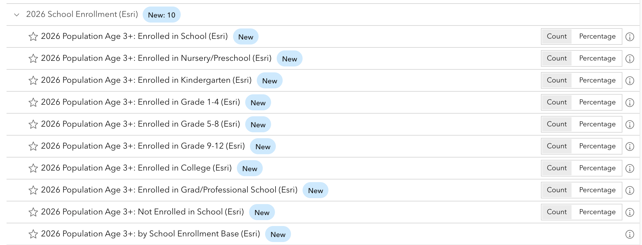
The dataset also expands Age by Income reporting from 9 to 20 income ranges across seven age groups, enabling more detailed analysis across life-cycle stages.
Learn more.
Census updates
The 2020 Census dataset has been updated to 2026 geography boundaries for the United States and Puerto Rico. In addition, Census variables that were previously only available down to the tract level of geography are now available at the block-group level. This includes topics like multigenerational households, single-year age, and more. Learn more.
Census 2010 and Census 2000 datasets have also been updated to align with 2026 geographies.
ACS 2020–2024 updates
The American Community Survey has been updated to include the latest 2020–2024 five-year estimates for the United States and Puerto Rico. In addition, ACS variables that were previously only available down to the tract level of geography are now available at the block-group level/Esri’s complete geography stack of 30 levels. This includes topics like detailed ancestry and ethnicity, poverty status, and more. Learn more.
ArcGIS Tapestry (2026)
ArcGIS Tapestry has been updated with refreshed counts. Some block groups have been reassigned the predominant Tapestry code to reflect new counts.
Market Potential (2026)
The 2026 Market Potential dataset adds 114 new variables, retiring 21 variables.
New variables include online grocery shopping preferences (home delivery, curbside pickup, and pickup locations), health and wellness indicators such as medication usage and smoking behaviors, travel planning habits, and nicotine product usage.
Removed attributes include grocery delivery and curbside pickup preferences, video streaming service usage, mobile app-based food ordering, smartphone ownership indicators, cigarette and e-cigarette usage, and travel planning activities across hotel, airline, and travel booking websites.
Consumer Spending (2026/2031) and Retail Demand (2026)
Consumer Spending and Retail Demand data have been updated with the latest 2024 Bureau of Labor Statistics Interview and Diary Survey data.
These updates provide a current view of household expenditures across hundreds of spending categories, helping organizations better understand consumer demand and purchasing trends. While the Consumer Spending dataset lists the products or services a regional household is likely to purchase; the Retail Demand by Industry dataset shows where they are likely to purchase them.
Urbanicity Type (2026)
Urbanicity Type data provides an analysis of urban, suburban, and rural communities. With this information, organizations can better understand how population density, development patterns, and settlement characteristics influence markets and behaviors.
Crime Indexes (2026A)
Crime Indexes data has been updated to the 2026A vintage and are now included in ArcGIS Business Analyst Enterprise and ArcGIS Business Analyst Pro data packs.
This enhancement allows organizations to access and analyze crime data in supported workflows behind their firewall. This dataset is sourced from Applied Geographic Solutions (AGS).
Business Summary (2026)
Business Summary introduces seven new healthcare business categories based on NAICS classifications (SIC codes are no longer available)
- Physicians and Doctors
- Dentists
- Other Health Practitioners
- Outpatient and Urgent Care Centers
- Medical and Diagnostic Laboratories
- Home Health Care Services
- Other Ambulatory Health Care Services
These additions support more detailed healthcare market analysis and site selection workflows. This dataset is sourced from Data Axle.
Canada updates
Canada Advanced Demographics
Canada Advanced Demographics has been updated from the 2025 to the 2026 vintage using data from Environics Analytics.
Key additions include the following:
- 2046 household and population trend projections
- 2045–2046 household and population growth rates
- 2046 aggregate household income trends (constant and current dollars)
- 2045–2046 aggregate household income growth rates
- 2046 average household income trends (constant and current dollars)
- 2045–2046 average household income growth rates
Learn more about how to access Esri Demographics:
- Esri Store—Buy individual Esri Demographics U.S. datasets.
- Esri Reports—Buy individual Esri Demographics reports.
- ArcGIS GeoEnrichment Service—Enhance apps and workflows with demographic data queries that add context to your data.
- ArcGIS Online—Access demographic map layers in the Esri Demographics Item gallery.
- Use the Enrich (Layer) function in ArcGIS Online Map Viewer, ArcGIS Enterprise, or ArcGIS Pro to append demographic data to your own location-based data.
- ArcGIS for Microsoft products (ArcGIS for Excel, ArcGIS for Power BI, ArcGIS for SharePoint, ArcGIS for Teams, and ArcGIS Connectors for Power Automate) use data enrichment. For example, you can add an information card, a layer from ArcGIS, use any of the Excel GeoEnrichment functions, or use the Power Automate ArcGIS GeoEnrichment Service action.
- In ArcGIS Business Analyst Web App, ArcGIS Business Analyst Pro, ArcGIS Business Analyst Enterprise, and ArcGIS Business Analyst Mobile App, you can enrich your maps with demographic data, create enriched content from a large template library, or customize your own reports and infographics.
- Learn more about using and understanding Esri Demographics with Data Guides


Commenting is not enabled for this article.