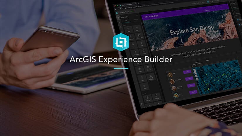
The February 2023 release for ArcGIS Experience Builder in ArcGIS Online introduces many new features to help you easily build no-code and low-code web apps and pages.
We’ve added the Add Data widget and the Slice tool is now available in the 3D Toolbox widget. Other highly anticipated improvements include the ability to choose which layers display in the Map Layers widget, support for end users defining locations or geographies for infographics in the Business Analyst widget, support for displaying elevation profile lines for 3D mesh layers, and new histogram charts. Let’s explore these features.
Add Data
The Add Data widget allows you to add data on the fly via ArcGIS content, URL, or local files.

Currently only Shapefile, CSV, and GeoJSON files can be uploaded, and supported URL types are as follows.

Please note there are limitations on the file size and number of records you can upload. For example, CSV files are limited to a maximum of 1,000 records. See Add Data for more information.
Action
To automatically add data to the map as shown above, use the Data added message from the widget to trigger the Add to map action.

End users can also take actions to filter data they just added or view it in a table.

Enhancements
Map Layers
Sometimes it may not be appropriate to show all layers in the Map Layers widget. You can now choose which layers display in the widget with the Customize layers setting.

Chart
The new histogram chart is appropriate for showing distribution. To create histograms, you must use data that supports percentiles. Learn more about layer properties.

Business Analyst
The Business Analyst widget is out of beta with a significant number of new capabilities. For instance, it now has two modes—Workflow and Preset. The former, shown below, provides end users with step-by-step panels for defining a location or geography and running an infographic. The latter embeds an infographic with preconfigured settings.

The Business Analyst widget can also interact with other widgets including List, Table, Search, and Map. For example, in the below GIF, selecting a county name from the list automatically triggers an infographic update.

For a complete list of improvements added in this release, check out this Esri Community blog post.
Elevation Profile
With Elevation Profile widget, you can now display scene layers, integrated mesh layers, and layers with volumetric 3D symbols in web scenes. The following example displays the elevation profile lines for both the ground and buildings.

To generate an elevation profile for buildings, enable the Show in graph option under Volumetric objects in the Profile Settings, and customize the label.

In addition, you can use the new Select line message action to make the Elevation Profile widget interact with other widgets.

In the following example, selecting a line feature in the table generates a profile. Also, the widget generates an output data source that other widgets can use. For example, display the values for maximum distance and elevation dynamically in the Text widget when a new profile is generated.

3D Toolbox
With the new Slice tool, you can slice a layer, such as a warehouse, up and down to reveal features inside as demonstrated below. You can also slice it horizontally with any angles.

Grid
Some of you would like to arrange the grid items before you add any widgets. You can now do so easily with the new Split vertically and Split horizontally buttons.

Templates
There are five new default templates. You can find them by looking for the New badge on their thumbnails in the Templates gallery.
- Pamphlet (full screen) focuses on the map, navigating cards to emulate flipping through a pamphlet.
- Avatarboard (grid) has multiple cards with hover and flip-over effects.
- Mapflyer (grid) shows coordinates and location information from a map.
- Leaflet (grid) displays text and images inside multiple columns.
- Collage (grid) surrounds a topic with multiple images.

In addition, the Utility Network Trace widget is now out of beta. For more information, see What’s new in Experience Builder. Please reach out to experiencebuilder@esri.com with questions.
Thank you,
The ArcGIS Experience Builder Team
Subscribe to our newsletter to receive the latest ArcGIS Experience Builder updates, news, and content.


Article Discussion: