ArcGIS Field Maps is a powerful mobile app solution that streamlines field workflows for exploring maps, collecting and updating authoritative data, and sharing where mobile workers have gone, all within a single location-aware mobile app. Released in November 2020, Field Maps is Esri’s premier, map-centric mobile solution for smartphone and tablet devices.
We have many exciting new development initiatives underway for 2022 and we’ve opened our early access program so you can start using new features coming in our Q1 and Q2 releases this year.
Sign into the Early Access Program and start using our beta apps today! Here is a preview of what’s available now.
Form Calculations
ArcGIS Field Maps is driving a major new initiative to bring smart form capabilities across the ArcGIS system. Using the Field Maps web application or the Map Viewer, you can author forms that bring structure and focus to web and field data entry workflows. If you are hearing about forms for the first time, please watch our introductory YouTube video or complete our current learn path for getting started with forms.
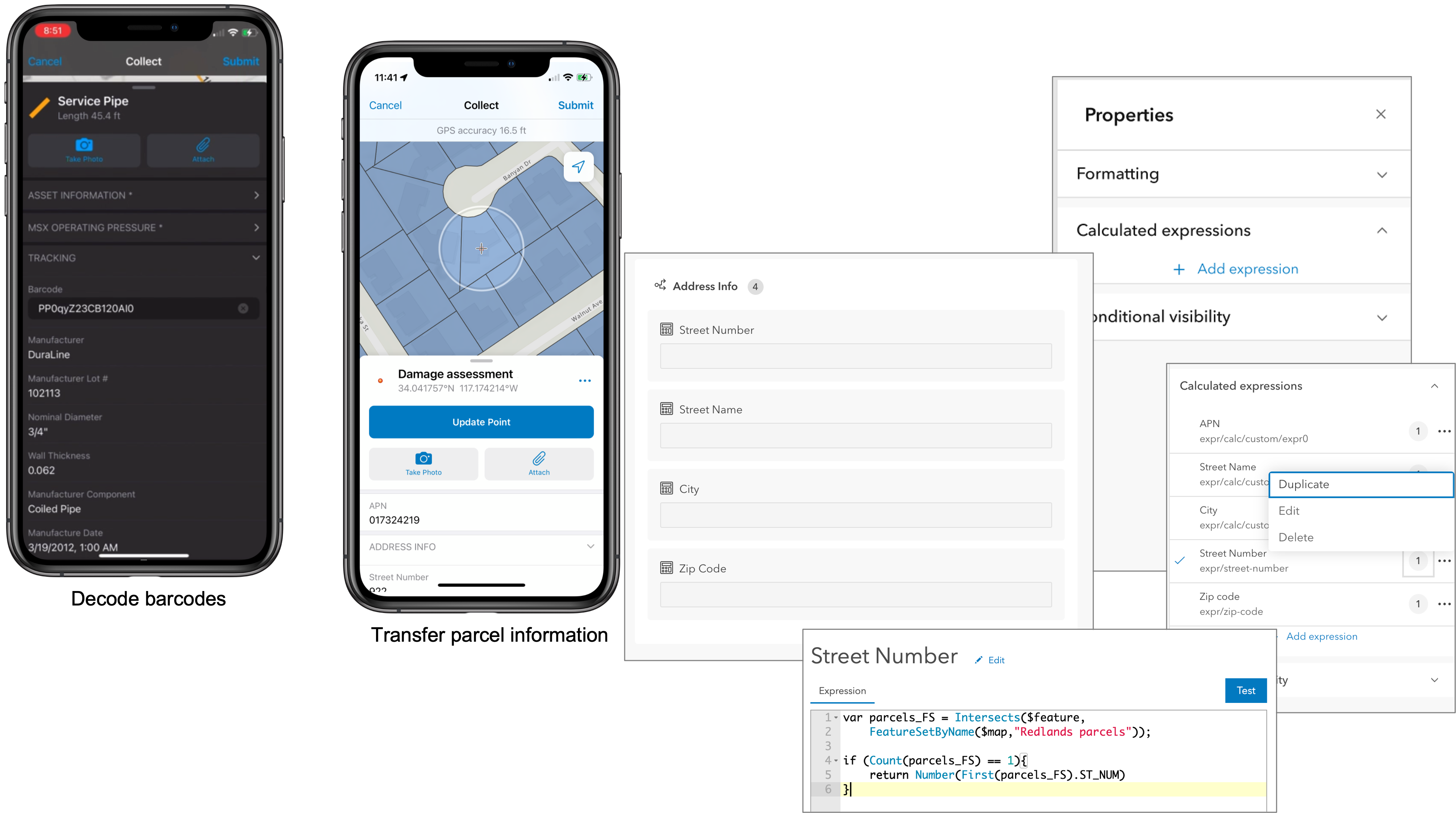
Fully supported offline, now you can automatically transfer address information from a parcel to a newly placed point contained within, use the camera to scan and decode barcode information in realtime and store details with the new pipe placed in the ground, or pull the email address and full user name details of a signed in contractors for follow up.
Form calculations harness the power of the Arcade expression language to improve the efficiency of form editing and minimize data entry errors by automatically calculating values as you edit them. Form calculations can use geometry, attributes, map layers, tables, equations, spatial operators, and the portal connection of the signed in user to enhance the form editing experience.
Following the pattern set with conditional visibility, calculated expressions can be added to a field using the Field Maps web application for form elements on feature layers or tables in web maps.
Using the EA version of the Field Maps web app you can author calculated expressions to maps today and use them in a beta build of iOS mobile app. An Android beta version will be available prior to release in March.
Linear Referencing
Highways, railroads, pipelines, and electric transmission lines, employ a linear referencing system to store relative positions called stations along existing linear features.
Engineering firms take horizontal alignments to the field for project verification, DOT’s take routes to the field when completing a sign inventory, and pipeline workers take engineering and continuous measurement routes to the field when inspecting a pipeline. Each of these workflows have a common need – to find and discover stationing (or measurement) values stored within a route feature.
With the Q1 release of Field Maps, a new Find Measure action will appear when a route is selected so the mobile worker can discover measure values closest to their current location or search for a measurement values along the route. From the interpolated location, they can use the compass tool or driving directions to get to the location or collect new features that store measurement value automatically.

Utility Network
In 2022 we plan to release support for the Utility Network in ArcGIS Field Maps on both the iOS and Android platforms. Important to our development is that we expose the power of the Utility Network while maintaining ease of use within ArcGIS Field Maps. Last year we introduced the following capabilities on the iOS platform and they are now available for beta testing on both the iOS and Android platforms:
Network tracing
Within ArcGIS Pro, you can configure a trace and provide network tracing capabilities to your mobile workforce using a named trace configuration. Named Trace Configurations contain all the parameters of a trace and hide the complexity from the mobile worker. Each map can have a set of named trace configurations shared with it and any named trace configuration shared will show up when that map is used in Field Maps when a network element is selected.
Showing Connectivity and Structural Attachment Associations
Field Maps is the ideal mobile app for viewing a utility network. Distribution networks include a lot of map layers, and grouping layers together so that you can work with them effectively on a mobile device is critical. When a map includes a utility network, Field Maps becomes aware of the network and you can discover additional ways to visualize the content within your network. Opening the Layers tool, you will see a section titled NETWORK LAYERS where you can turn on/off visualization of network connections and attachments.
Containment
Containment is an association relationship in the Utility Network. When you select a feature which acts as a container in the Utility Network, the View Contents feature action will be visible in the panel which appears when a feature is selected and will provide the number of contained elements. Tapping on the feature action, you can drill down and select each individual element and access its details.
What else are we working on?
We are actively working on additional, key development projects for ArcGIS Field Maps. Some will release with our Q1 updates and some will appear in Q2.
- Contingent attribute values – authored and published using ArcGIS Pro, contingent values introduced a new way to model classifications within form elements. Consider filtering choice lists based upon a biological classification such as genus > species or a device classification by make > model. Support for contingent attribute values in Field Maps will be released in Q1 and available for beta testing in the early access program soon.
- GPS metadata for lines and polygons – Field Maps supports high-accuracy GPS data capture workflows for points, lines, and polygon features. Until now, GPS metadata fields have only been captured for points. With the Q1 release we are adding support for capture of GPS metadata with lines and polygons as well.
- High accuracy configuration and deployment – using a realtime correction source, mobile workers can capture data to an accuracy of 1 centimeter (horizontal or vertical). Configuring a location profile in Field Maps, mobile workers can choose a datum transformation that will transform incoming GPS positions from the spatial reference of the corrected data source to the spatial reference of their map. This is an advanced workflow and prone to error for a novice user. With the Q1 release, organizations that deploy and manage Field Maps using an Mobile Device Management system can push a location profile and offset parameters to devices and simplify the configuration process.
- Geotriggers – a new development for Field Maps, organizations can use Geotriggers to improve operational awareness (connected or offline). In the Q2 release, map authors can use the Field Maps web app to configure one or more geotriggers from a map layer that include customized location alerts that will notify mobile workers when they enter or exit a geofence location. Geotriggers can also be used to control the behavior of location sharing within Field Maps such that realtime locations are only recorded and shared when within or outside a given geofence area. Geotriggers is planned for beta release at the end of Q1.


Article Discussion: