ArcGIS Field Maps is Esri’s premier all-in-one mobile app that combines map viewing, high-accuracy GPS data collection, form-driven inspections, task coordination, and location sharing into a single app that is deeply integrated with the ArcGIS system.
This year we’ve witnessed significant growth in adoption and use of Field Maps. We’re quickly approaching 1M unique, monthly active mobile users. A big thank you to all our Field Maps users and to those that provide feedback through Esri community, surveys, and our early access community.
The November update marks our third and final major release of 2026 and like the March and June updates, we’ve added lots of new capabilities, quality of life improvements, and bug fixes.
First, let’s take a look at these top 5 new capabilities:
- Using the new Dynamic choice form input.
- Capturing underground utility assets with RTK-capable utility line locators.
- Deeper integration with select GNSS providers to enhance high-accuracy data capture.
- Capturing offset locations using LaserTech rangefinders and Trimble GNSS receivers.
- Sharing location in remote locations using constrained, satellite networks.
Then let’s take a look at the quality of life improvements and bugs we squashed. If you read to the bottom, we’ll provide a glimpse into what’s coming next year as well.
For a comprehensive list of what’s new in the November 2026 release, please reference our what’s new documentation topic.
Dynamic choice
Dynamic choice is a new choice input type that map authors can use to generate a focused list of choices for mobile workers. Authors can define choices in the form or generate them from layers or tables. This helps mobile workers select the correct value and reduces the need for form authors to update lists/coded-value domains and modify their map schema.
When authoring a form, dynamic choice is now available as a choice list input type that you can add to your form. It supports all field types and depending on field type chosen can optionally support a list or range.
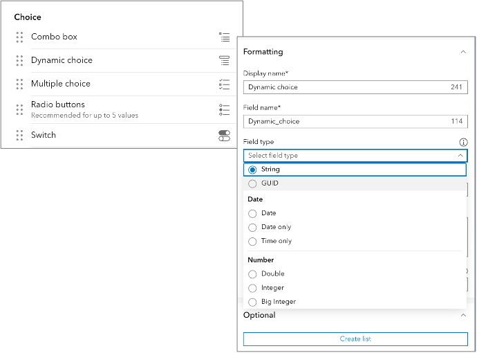
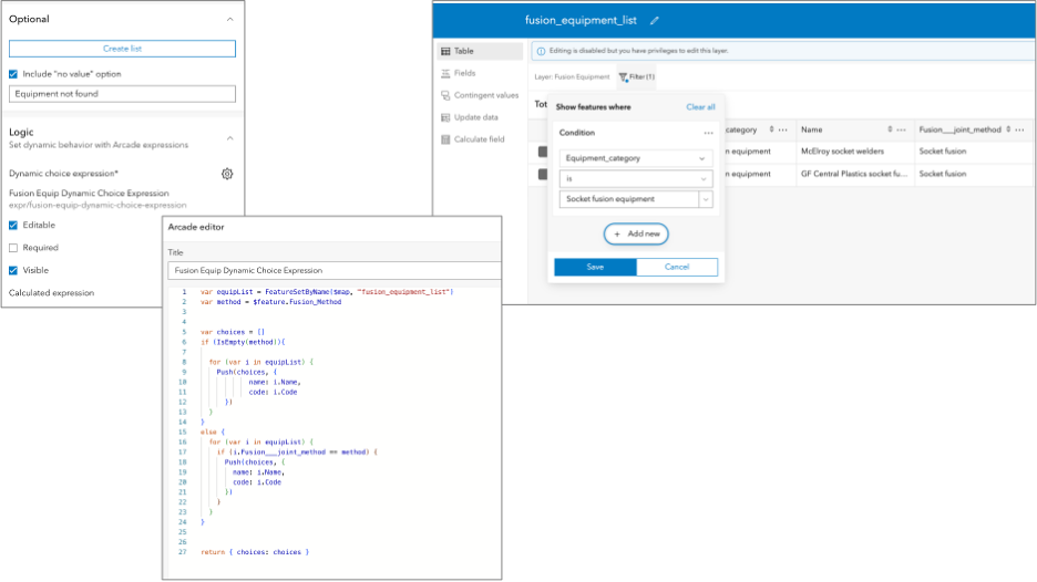
An Arcade expression, which you set in the Logic panel, drives the list using the Form Dynamic Choice profile. A common pattern with dynamic choice is to query and optionally filter a table, dynamically, to present the list of choices.
The example below shows how you can write an Arcade expression that generates the choice list from a separate table named fusion_equipment_list where another form input applies a filter on the table.
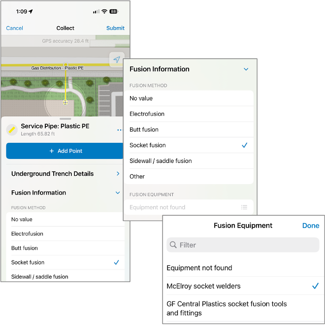
Within Field Maps, the choice list will appear when tapping on the form input. In this example, a selection in the “Fusion information” choice list filters the table and generates a dictionary that Field Maps presents to the mobile user as a choice list.
Mobile workers can take forms with dynamic choice input types offline when the data required by the expression is available in the offline map area. To use Dynamic choice offline, make sure to include any referenced layers or tables in the map and confirm that they support offline use before downloading the map area.
The Forms tab in Field Maps Designer now supports browsing for tables when adding layers to the map. Remember to ensure that tables are included in offline map areas as well. Read the Work with dynamic choice offline topic for details. For more information about the dynamic choice form input, reading the Configuring a dynamic choice input type topic.
Locate underground utility assets
The direct integration of RTK-capable utility line locators with ArcGIS Field Maps introduces an experience to accurately locate underground utility assets. Like other GNSS receivers, you can add a utility line locator as a Location Provider in the location settings. The locator companion app maintains a connection to the device and to a correction source to provide centimeter-accurate positions.
Mobile workers can capture a utility line feature and Field Maps will automatically collect locate point features that include both GPS and locate metadata.
The 26.3.0 release supports locators from Radiodetection and Subsite. Locators from Vivax-Metrotech will be coming soon.
Getting Started
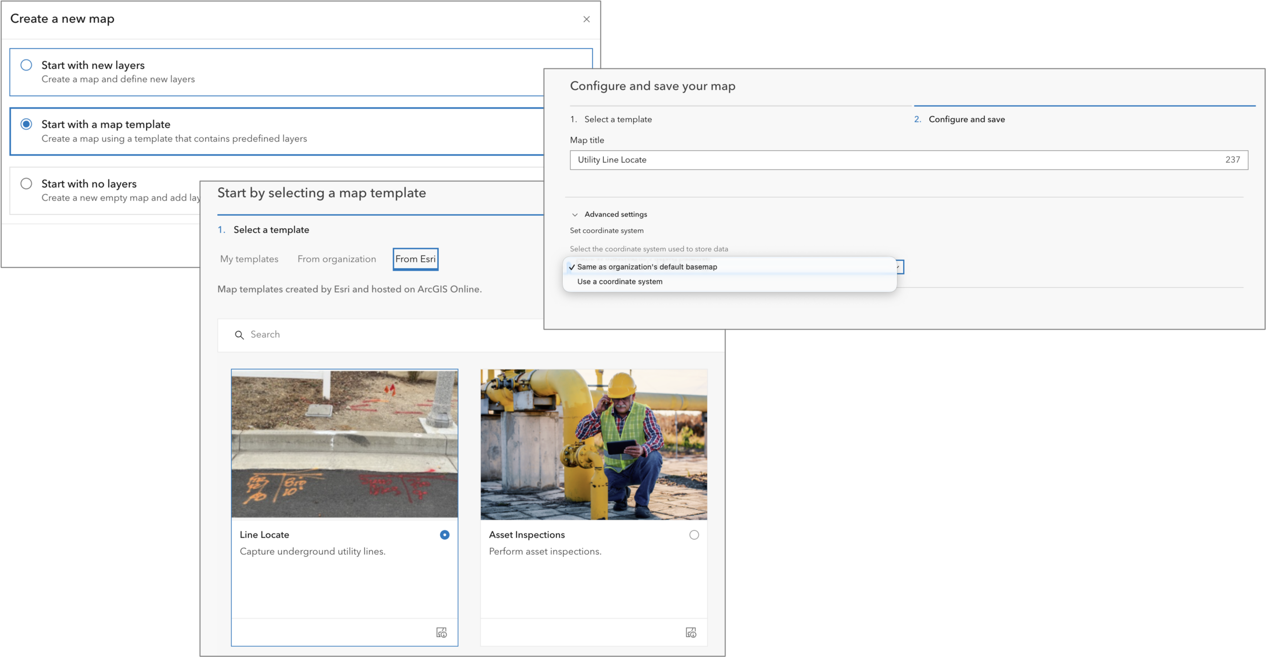
Field Maps Designer includes a new Esri Line Locate map template. Use this template to create a map that supports advanced data capture capabilities and stores critical GNSS and locate metadata attributes for each utility line type. The Line Locate map template allows utility locate technicians to capture the location and depth of underground pipes and wires using a supported utility line locator. It combines utility line features with automatically recorded positioning and locator metadata to provide a record of field observations.
Maps created using this template contain two related layers, a Locate lines layer and a Locate points layer. The Locate lines layer is the primary data collection layer. It is where technicians record utility types, ticket numbers, and photos. When a position is captured from the locator, Field Maps automatically creates a corresponding Locate Points feature containing GNSS positioning information and locator metadata, such as depth, frequency, and signal strength. Locate Points is hidden from the collection experience.
From the maps page in Field Maps Designer, click New Map, choose to start with a map template, and pick the From Esri tab to find the Line Locate map template. From here, follow the template creation process. If you want to create feature layers in a local projection open the Advanced settings and choose the appropriate projection.
Capture underground assets
The direct integration of RTK-capable utility line locators introduces a unique experience for accurately locating underground utility assets. Similar to other GNSS receivers, a Utility line locator can be added as a Location provider in the location settings. The locator companion app maintains a connection to the device and to a correction source to provide centimeter-accurate positions. Unique to the experience in Field Maps is that when using a configured Line locate map, mobile workers can capture a utility line feature in the Locate lines layer and automatically collect point features in the Locate points layer that include rich GNSS and locate metadata.
Tapping the Add  button, you then choose the appropriate type of utility line to capture. Field Maps enters locator collect mode and the panel shows Use Device for location capture and is now optimized to capture locations from the locator device. Pressing the capture button on the locator device you will hear a beep and receive haptic feedback letting you know that capture was successful. Each press records both a vertex in the Locate Lines layer and a point in the Locate Points layer. Once finished capturing locations, you can finish entering any required form inputs and tap Submit.
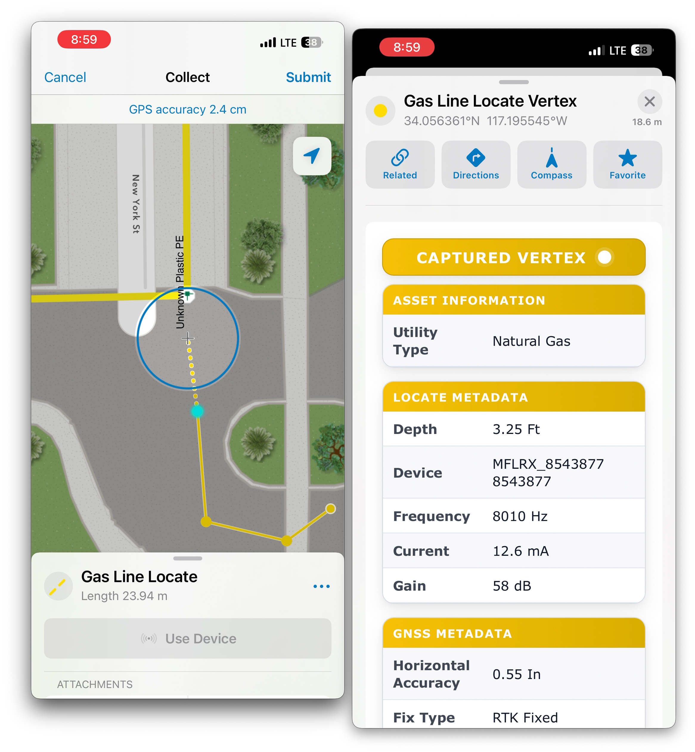
If you’d like to capture above ground assets using locations received from the locator device, simply add additional layers to the map. With the device set as the Location Provider, it will provide locations to Field Maps just like other GPS receivers.
If you are using ArcGIS Enterprise, there is an ArcGIS Pro project template that you can download and use to create the Line Locate map as well.
Enhanced high-accuracy data capture
Pairing high-precision GNSS receivers with ArcGIS Field Maps enables field teams to capture new data and/or update the quality of existing data directly into their GIS system. Field Maps has included support for high-accuracy data capture since it was first released in 2020 and with each release we’ve added new receivers and receiver manufacturers.
We’ve introduced a new pattern of integration with select GPS receiver manufacturers that enhances the configuration and capture experience. Some GPS receiver manufacturers support connecting via their companion app if installed on your device. This method relies on the manufacturer’s app to communicate with the GPS receiver, which offers several benefits over the traditional method of Field Maps directly connecting to the GPS receiver. Supported receiver manufacturers that connect to Field Maps using their respective companion app include Trimble, Leica, Bad Elf. Eos companion app support will be coming soon.
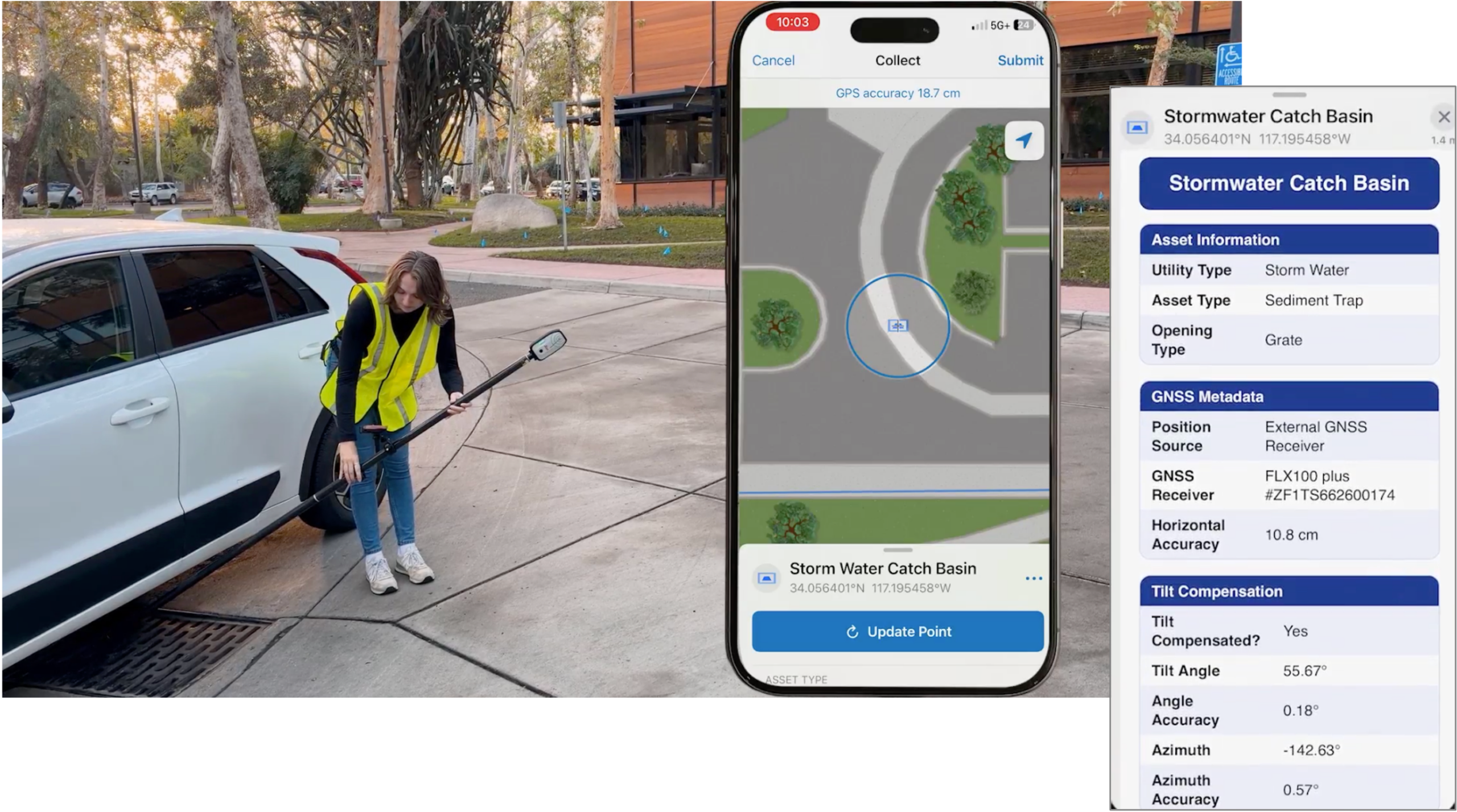
This connection method supports a broader set of GPS metadata including:
- Application settings:
- 95% accuracy applied – when evaluating horizontal and vertical accuracy, this setting indicates if it is based on RMS or if the confidence conversion factor is applied.
- Location profile horizontal datum transformation – name of the horizontal datum transformation if set within the location profile settings.
- Location profile horizontal datum transformation applied – indicates if a horizontal transformation was applied by the location profile, including the following possible values: 0—No, 1—Yes.
- Elevation attributes:
- Antenna height – value in meters, specified when capturing accurate elevation values.
- Orthometric height – value in meters,
- Receiver geoid model – model used to compute orthometric height.
- Tilt attributes (applied when using tilt-capable receivers):
- Tilt compensated – was the location captured with tilt compensation
- Tilt angle (°) – tilt angle applied
- Tilt angle accuracy (°) – tilt angle accuracy measured
- Tilt azimuth (°) – direction of tilt
- Tilt azimuth accuracy (°) – measured accuracy of tilt direction
- Correction source information:
- Correction source type – type of correction applied (Direct IP, NTRIP, PPP, etc)
- Correction source name – name of the correction source (example “Galileo HAS”)
- Correction age – time delay between when a base station calculates positional corrections and when those corrections are successfully applied by your mobile receiver (in seconds)
- NTRIP mount point – specific access gateway used when connecting via NTRIP
It’s important to Prepare your data to record GPS metadata and now you can update layers that may be missing new GPS metadata fields in Field Maps Designer. The Field Maps scripts repository includes several scripts for adding and updating GPS metadata to feature layers and the Add GPS Metadata Fields geoprocessing tool that is included with ArcGIS Pro will update to support the latest metadata attributes in its next release.
Please read our Connect using a companion app topic for more details.
Offset capture using Trimble Mobile Manager
Field Maps, paired with a high-accuracy GNSS receiver, can capture the location of features with centimeter-level accuracy, where you stand. However, sometimes you’re not able to occupy the location you wish to capture. Locations can exist in hard-to-reach, hazardous, or blocked locations.
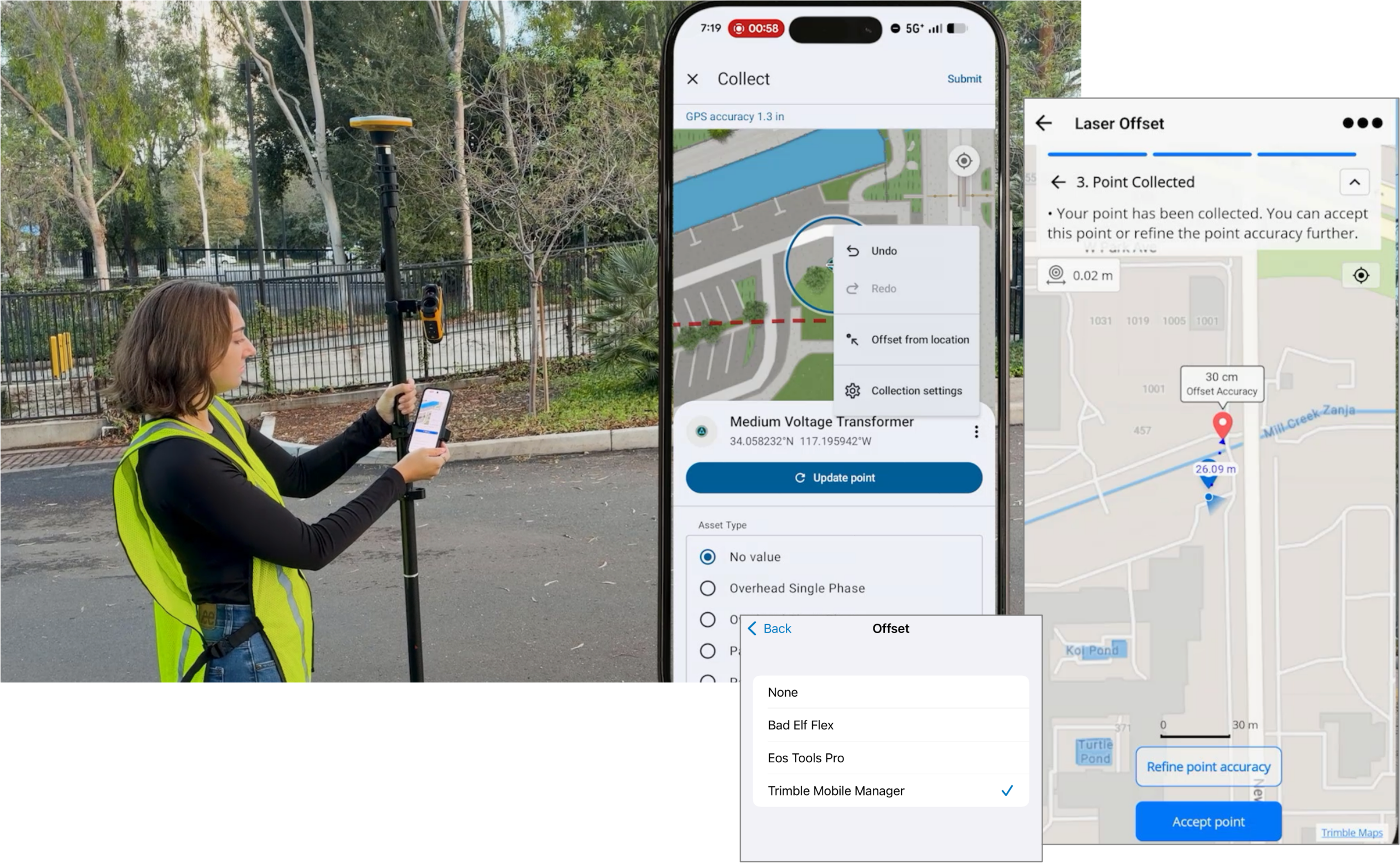
With the 26.3.0 release, now you can use a LaserTech TruPulse laser rangefinder and Trimble Mobile Manager, as an offset provider, to measure the distance from your current location to a remote location and capture the offset location with accuracy. Field Maps will store comprehensive metadata attributes for each offset method chosen.
With Trimble Mobile Manager installed and set as the preferred Offset provider in the Field Maps Collection Settings, tapping the Offset from location collection tool from the panel menu when collecting a feature will open Trimble Mobile Manager and present an intuitive experience for capturing an offset location using distance-azimuth or a distance-distance method depending on the paired, supported, LaserTech LaserRangefinder and environment conditions. Tapping Accept point will send the offset location to Field Maps along with extensive offset and GPS metadata.
Make sure to add the Offset Metadata Fields prior to the appropriate feature layer.
Sharing location over satellite networks
Location sharing is an organization-wide capability that allows you to see where mobile users are and where they have been. When an administrator enables location sharing, mobile users in your organization can use the ArcGIS Field Maps mobile app to share their location to the location sharing layer that can then be securely shared within maps and dashboards to improve situational awareness.
For emergency responders, utility crews, engineering teams, and other mobile workers, remote work is essential work. When cellular coverage drops, back-office coordinators lose visibility of where their teams are, where they have been, and how work is progressing across an operation.
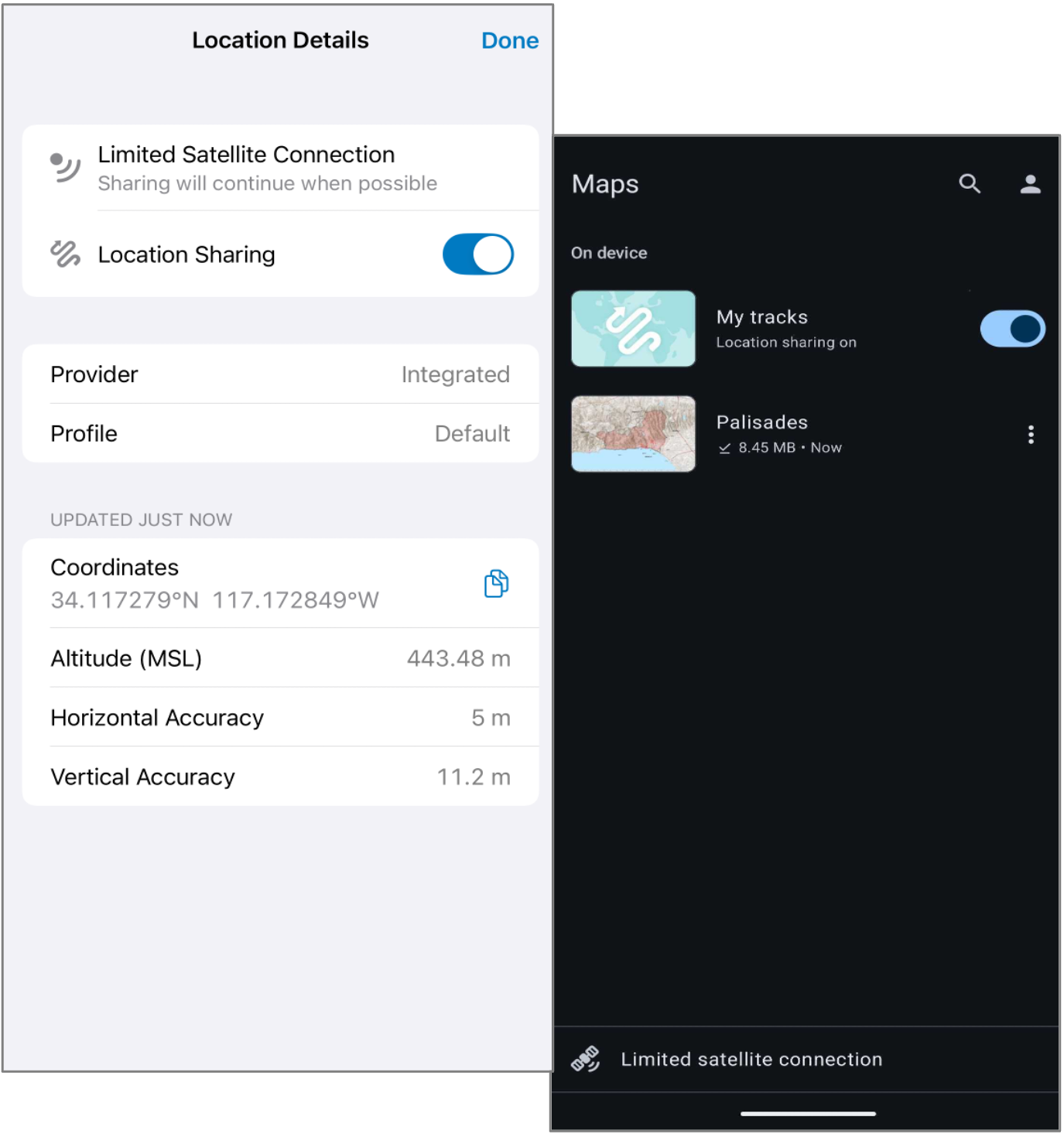
ArcGIS Field Maps has been optimized to provide access to carrier-provided satellite connectivity on both the iOS and Android platforms. This technology enables compatible phones to communicate directly with low Earth orbit satellites, helping maintain basic connectivity, filling gaps in cellular coverage, without requiring separate satellite hardware. Field Maps support of satellite connectivity is agnostic of any carrier network.
When a compatible iOS or Android device moves outside cellular coverage and connects through carrier-provided satellite network, Field Maps detects that the device is using a limited satellite connection and adjusts the app experience accordingly.
ArcGIS Field Maps can utilize a limited satellite connection to:
- send the mobile user’s last known location every minute.
- send the user’s track history every 10 minutes.
These settings are the same for a cellular or Wi-Fi connection. If your organization has configured a different interval using supported app links or MDM parameters, then the defined frequencies for last known location and track history uploads will apply for all connection types.
Sharing location does not require that you open and use a map, but seeing your location on a map as you are in a remote location is more reliable if you have an offline map so make sure that you download needed map areas before going to the field. Check with your carrier for support of satellite or “direct to cell” capabilities. Most providers will provide a coverage area map so you can identify locations where satellite connectivity matters most.
Quality of life improvements
The November release includes several quality of life improvements as well as the new capabilities listed above. We’ve included several quality of life improvements:
- Subtype Group Tables – non-spatial tables can be categorized using subtypes, just like feature layers can and layers can reference a subtype within a table as well. This is a common and well-used approach for modeling non-spatial utility assets. Field Maps now supports the form authoring, editing and pop-up element.
- Edit Multiple Tool – added support for Multiple choice form inputs so you can update the attributes of many features simultaneously where this input type is used.
- Subtypes – prior to this release, Field Maps did not properly support feature templates where the feature type differed from the subtype. This has been resolved!
- Transformations – we’ve updated the list of supported coordinate systems and transformations used with location profiles. This includes support for CSRN Epoch 2025.0.
- Tables – now you can directly add subtype group tables and tables to your map using the Add Layers button in Field Maps Designer.
- Map templates – when creating new maps using map templates, we’ve enabled the display and use of Esri template by default.
- GPS metadata – now you can update an existing feature layer to include GPS metadata fields not present on the layer.
We’ve squashed a lot of bugs in this release too. Here are a number of issues that you’ve submitted and we’ve resolved:
- Field Maps mobile app fixes
- BUG-000182239, BUG-000187241, BUG-000186548, BUG-000186310, BUG-000186265, BUG-000185842, BUG-000185605, BUG-000185386, BUG-000185270, BUG-000184569, BUG-000184376, BUG-000184331, BUG-000184328, BUG-000184045, BUG-000183985, BUG-000183476, BUG-000182942, BUG-000180649, BUG-000180359, BUG-000180142, BUG-000185465
- Field Maps Designer fixes
What’s next
Before talking about our ambitious road map for 2027, we have minor updates that will come before the end of the year:
Location sharing licensing changes
We’re providing more access to how location sharing can be used within your organization. Sharing location will be available to all user types, including Viewer and sharing location history will be available to Creator and Professional/Professional Plus user types. Two member content privileges have been added that the 26.3.1 release will honor:
- Share location – Allow member to share their last known location when location sharing is enabled.
- Share location history – Allow member to share their location history tracks when location sharing is enabled.
For more details on the licensing changes, please read the Location Sharing Licensing Changes blog article.
2027
Next year we will have 3 major releases in February, June, and October. Field Maps updates match the cadence and timing of ArcGIS Online releases.
There’s a lot of new capabilities coming in 2027, let’s take a look at what’s under consideration:
- iOS app experience – early in 2027, expect to see beta updates that embrace the Apple design patterns of Liquid Glass. We’ve been working on this for some time and are excited to bring it forward.
- Advanced editing templates and collect experience – the collection experience in Field Maps is predicated on use of feature layers and their templates. Editing templates have evolved considerably over the past few years, and next year we will advance the configuration of editing templates in Field Maps Designer and bring forward a subset of the construction tools that are available in web editing apps and ArcGIS Pro. This will include support for freehand capture on the map and a new experience for the Collect tool.
- Form improvements – an ongoing theme, look for Field Maps to embrace more advanced form capture capabilities including AI-assisted data capture, more sensor-based inputs, improved form editing performance, and more.
- Teams – with the introduction of tasks and the fusion of location sharing in Field Maps, we intend to bring forward the concept of working together as part of a team. This includes knowing the location of other team members, adding attributes about the team member (role, number, work load, etc).
- Offline – we’re working across teams to improve the offline experience in 2027. This includes the packaging and download of map areas, the management and creation experience for offline map areas, updates to referenced basemaps, and a more robust and forgiving offline map experience on device.
- Visualization and navigation experiences – we’re expanding the abilities of the compass tool to include a precise navigation experience that supports design, construction, and utility damage prevention workflows. At the same time, we’re working on a new version of ArcGIS Navigator, for vehicle-based navigation, that will bring an enhanced user experience that includes Apple CarPlay and Android Auto support. Finally we are researching how to include augmented reality to aid the locate and inspection of assets and viewing of 3D web scenes to aid situational awareness for responders and understanding of BIM models for engineers.
As always, our plans and direction are subject to change. We really want to hear from you on our direction and your experiences. Please reach out to us on Esri Community. If you would like to connect with and learn from your fellow users, please join our LinkedIn group.

Article Discussion: