The Living Atlas of the World is a rapidly growing part of the ArcGIS Platform, providing users with easy access to a rich set of high-quality, ready-to-use content published by Esri and the ArcGIS user community. With this newsletter and related resources, we would like to inspire and empower you to become an active participant in our worldwide Living Atlas Community.
Background
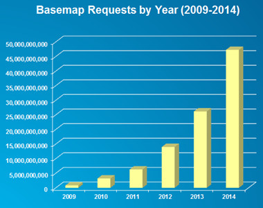
For several years, ArcGIS Online has provided users with access to ready-to-use content that could be used to publish and share maps and applications. This began with a small set of basemaps, and other foundational services such as geocoding and routing, which were quickly adopted by ArcGIS users. To enhance the quality and coverage of these services, many of these ArcGIS users offered to share their geographic data with Esri to integrate into the maps and make available to all users. As a result, the Community Maps program was born! This community initiative, along with the growth of ArcGIS Online and web mapping generally, has led to significant increases in the usage of these basemaps each year.
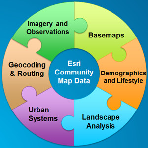
Over the past few years, Esri has also been expanding the types of maps and layers that it makes available to ArcGIS users. These maps have covered a wide range of topics related to people (i.e., human systems), earth (i.e., physical systems), and life (i.e., natural systems). This has included multispectral imagery, demographic maps, elevation layers, ecological land units, and much more. The intent of these maps and layers is to provide a diverse and useful set of ready-to-use content that can support a wide range of maps, applications, and geographic analysis.
Living Atlas Community
ArcGIS Online currently includes about 1 million items that are publicly available to all users, with the vast majority being web maps, map layers, or web mapping applications (e.g., story maps). Many of these items reference geographic information, published by authoritative sources, which would be useful to many users. However, given the volume of information in the system, much of this information can be difficult for those users to discover and access. One of the primary goals of the Living Atlas is to make the best of this information easy to discover and access.
The Living Atlas Community consists of two types of participants:
- Contributors: who publish content that is included in the Living Atlas
- Curators: who review, approve, and organize content that is included in the Living Atlas
Living Atlas Contributors can participate by (a) publishing content directly through ArcGIS Online and (b) publishing content indirectly through Community Maps. The content that is published by users through ArcGIS Online is reviewed by Living Atlas Curators, which includes dozens of Esri staff and other GIS professionals around the world. These curators review the content to ensure it is useful, reliable, and well described. Content that meets the acceptance criteria is included in the Living Atlas and featured in ArcGIS Online for other users to discover and access. To nominate your content to the Living Atlas, please visit our new Living Atlas Contributor app.
We believe that the Living Atlas provides access to one of the largest collections of useful geographic information that has ever been assembled. The Living Atlas is growing and changing continuously as new maps and layers are added by our Contributors and Curators, and existing maps and layers are updated with more recent data (e.g., live traffic and weather). The value of this content is being recognized by many users as they integrate layers into their maps and maps into their applications. It is also being recognized by the larger mapping community. In late 2014, the International Map Industry Association (IMIA) honored the Living Atlas with three awards, including Best Digital Map Product, Best Overall, and the Global Award. These awards reflect the quality and value of geographic information being made available by the GIS Community through the Living Atlas of the World.
We invite you to become an active participant in the Living Atlas and help us to make the useful geographic information you build and maintain available to other users around the world.


Article Discussion: