by Andrew Keske, Alex Yesto, Ilana Cohen, Peter Bonsall, Sandy Margriter, Susan Rosebrough, Joan Harn, Cathi Bailey, Steve Chesterson
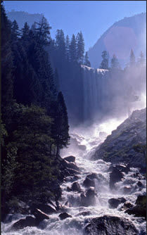
Rivers often inspire us with their magnificent beauty and have long been recognized for providing us with not only water, but also food, energy, and opportunities to recreate, experience solitude or gather with friends (Figure 1). Additionally, free-flowing rivers provide ecological benefits, such as clean water, flood mitigation, and fish and wildlife habitat, and they play a valuable role in the global water cycle. In order to protect and enhance water quality and the free-flowing nature of our most precious waterways, Congress passed the Wild and Scenic Rivers Act in 1968. Presently there are 208 national wild and scenic rivers in 40 States and the Commonwealth of Puerto Rico, totaling more than 12,700 miles.
To better manage these rivers, the four primary federal agencies with responsibility for the National Wild and Scenic Rivers System (the United States Forest Service, National Park Service, Bureau of Land Management, and United States Fish and Wildlife Service) developed an interagency geodatabase that includes information about each river and river segment, such as the river name, classification, list of responsible agencies, and outstandingly remarkable values, as well as links to documents and web pages. This new geodatabase is the authoritative data set for the National Wild and Scenic Rivers system and can be found here. The data is also linked the National Hydrography dataset reach codes.
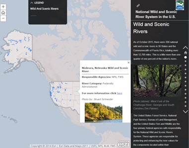
A sequence of interactive maps accessible via a Wild and Scenic River Story Map (Figure 2) were created using these data. Each story map page describes an attribute of wild and scenic rivers such as river’s classification, outstandingly remarkable values, and management. A link to the story maps is available on rivers.gov, the Interagency Wild and Scenic River Coordinating Council’s public website dedicated to wild and scenic rivers. The agencies also worked with Esri to create maps for each of the fifty states that highlight the rivers in that state and their management and maps for each of the 208 wild and scenic rivers that show the river’s classification and values. All of the state and individual river maps are also integrated seamlessly into the rivers.gov webmap.
These new tools provide accessible data and easy to use tools for agencies and the public to use. This project was done in part to celebrate the upcoming 50th anniversary of the Wild and Scenic Rivers Act.


Article Discussion: