Maybe you’ve got a huge collection of drone images or scanned maps that you aren’t sure how to manage. Could be that someone mentioned that you could use precipitation, soil type, and elevation rasters to find the best place to put your new vineyard. Maybe you’ve been hearing great things about using deep learning to find objects in imagery, but aren’t sure where to start.
That’s where the ArcGIS Imagery Workflows website comes in. The Imagery Workflows site provides a jumping off point for accomplishing common imagery tasks using the ArcGIS platform—things like managing drone imagery, managing scanned maps, site suitability analysis, or object detection using deep learning.
What are imagery workflows?
Each workflow briefly explains the ArcGIS solution to a common imagery problem, then aggregates helpful resources from across Esri to help you solve it. With each workflow, you’ll find links to relevant videos, blogs, tutorials, GitHub repos, best practices, Help doc, Learn lessons, custom geoprocessing tools, and more, all in one place.
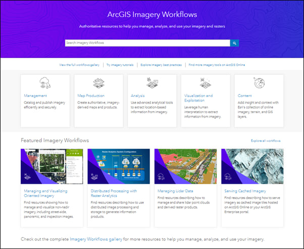
We’ve got a gallery of imagery workflows organized around the five imagery capabilities of the ArcGIS platform:
- Image management workflows to catalog and publish imagery efficiently and securely.
- Map production workflows to create authoritative, imagery-derived maps and products.
- Image analysis workflows to use advanced analytical tools to extract location-based information from imagery.
- Visualization & Exploitation workflows to leverage human interpretation to extract information from imagery.
- Content workflows to add insight and context with Esri’s collection of online imagery, terrain, and GIS layers.
We’re constantly adding workflows, so keep an eye on the gallery for new resources.
Plus, find imagery best practices, tutorials, and tools
The Imagery Workflows site also has other helpful imagery content—best practices, tutorials, and open-source tools. These are all included in any relevant workflow, but are also worth exploring on their own.
The imagery best practices section of the site provides deep-dive information about how to optimize your workflow for efficiency, scalability, usability, different data types, and more. Learn about things like the best way to structure and format imagery and rasters, or how to create and maintain mosaic datasets. This sections currently focuses on image management, but look for expanded content soon.
Imagery tutorials offer step-by-step instructions and links to sample data to get started with common imagery tasks—examples include creating oriented imagery catalogs, multidimensional raster analysis in ArcGIS Pro, or working with the Full Motion Video player.
Finally, link to our ArcGIS Online group to find open-source scripts and tools for working with imagery.
Tell us what workflows you’d like to see
Have you explored the Imagery Workflows website, but didn’t find what you were looking for? Tell us about it! We’re constantly adding new content, so use our Survey123 form to request a new workflow, tutorial, or best practices section.

Commenting is not enabled for this article.