By Ken Field, Esri Research Cartographer
Back in 2009, I (and my co-author Dr. Linda Beale) created a map showing the historical and numeric importance of Irish surnames. It won a few awards and featured briefly in a previous Mapping Center blog entry to recognize St. Patrick’s Day in 2010. A paper I wrote about this map has recently been published in the Society of Cartographers Bulletin that details the design philosophy and construction of the map in ArcGIS. Rather than repeating a description of the mapping techniques I used here, the paper itself is available to download from the Publications page of Mapping Center (courtesy of Society of Cartographers). But here is a brief review of the map.
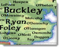
The purpose of the map was to provide a visual representation of the spatial and quantitative distribution of birth data from the 1890 Irish census of population. The birth data identified the surname of every child born, by county. The surnames on the map have either historic or numeric importance to the counties of Ireland and as such the map provides an illustration of the associated geographies.
A Celtic theme and connotations with the “Emerald Isle” added to the impact of the map as a product that would inspire people to view, interact with, and study; to evoke feelings of longing, recollection, and familiarity. This is what we call the “affective design” of the map….the result of a design process that marries aesthetics with usability. These would serve to give the map a strong identity and one which people would “warm to”. To achieve this, a design principle was developed around a typical “Irish” theme that played on familiar Irish imagery and styles that would be easily identifiable and which would create an immediate bond of attraction for the user. Ultimately, if a map is successful, it should attract a map reader and encourage him or her to spend time exploring what it has to offer. The design for the Irish surnames map was chosen to achieve this whilst properly representing the mapped data using proportionally scaled labels for the names.
One of the most common questions we get about the map is, “How do I get a copy?” Well, a high-resolution version of the map at A0 size can be downloaded from the Journal of Maps. You simply need to register to use the journal and the download is free. Coupled with the paper describing the techniques you should be able to create your own map of this style using ArcGIS. Enjoy!
References
Field, K. S. And Beale, L. (2011) “Designing an Irish Surnames Map using GIS”, Society of Cartographers Bulletin Vol 44, pp 3-10.
Field, K.S. and Beale, L. (2010) “Geo-genealogy of Irish Surnames”, Journal of Maps v2010 DOI: 10.4113/jom.2010.1128
Thanks to Aileen Buckley, Mapping Center Lead, for help with this (my first) blog entry. More to come…

Article Discussion: