Today marks the end of an era – the last update to the iconic COVID-19 Dashboard by the Center for Systems Science and Engineering (CSSE) at Johns Hopkins University (JHU). To commemorate this milestone, I wanted to express my love and appreciation for the amazing team at JHU and their tireless work that has kept the world informed for more than 3 years. Thank you so very much…
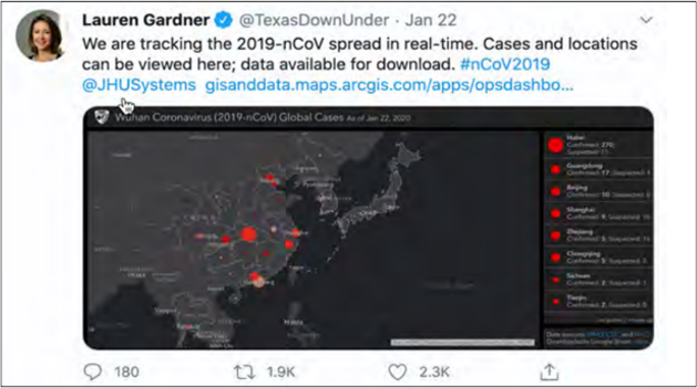
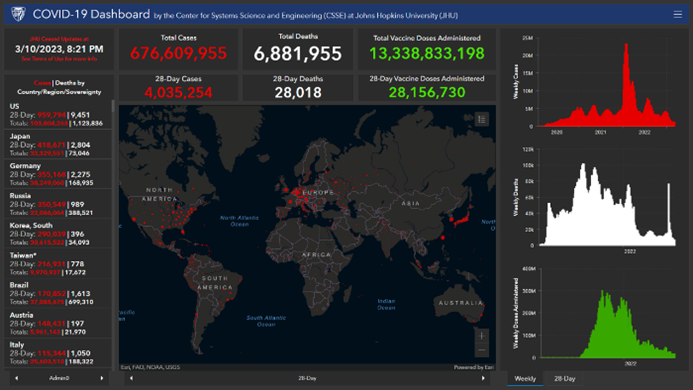
The JHU COVID-19 Dashboard may be the most recognizable symbol of the pandemic which has disrupted, disturbed, derailed, and devastated people’s lives. Just about everyone on the planet knows the dark grey base map punctuated by red dots spread out among the world’s countries. Viewed hundreds of billions of times since its launch, it’s the most viral map-based application in history.
But to me, this application is so much more than just a dashboard. Obviously, from an Esri point of view, we were delighted that JHU chose to build the application using ArcGIS Dashboards. It really highlighted how quickly a dashboard could be configured and shared (Ensheng Dong, the PhD student who built the application, says he did it in an evening). And with a bit of Esri support (led by my colleague, Sean Breyer and our amazing ArcGIS operations team), scaling the infrastructure behind the dashboard ensured it could withstand the tremendous traffic it received (14.8 billion views on its biggest day, March 20, 2020). Thank you, JHU for making Esri a part of your support team. An important requirement that the CSSE team at JHU had was to ensure the underlying data for the dashboard was open and machine-readable so anyone could use it. And they have. Thousands of organizations, researchers, and developers around the world have incorporated the JHU data into their own dashboards, analytics, and applications. Given the scope of the pandemic, the JHU data is among the most impactful open datasets ever created. Personally, I’ve been a huge advocate of open data since my days as a Deputy Director at the California Department of Public Health where I led its open data initiative. All my aspirations and musings about innovation arising from sharing high-value public health data were realized in this widely used COVID-19 dataset. Thank you, JHU.
My gratitude to JHU also extends deeply to the way the COVID-19 Dashboard did its job and informed our own personal health decisions. Many of us checked the numbers and the map routinely to see if a new wave was starting, or which locations were being hardest hit with cases. We tried to comprehend the immense loss of life and the human beings behind the growing number of deaths. I referred to the dashboard when I made my own decisions about staying in or going out. I sent links to my parents and friends, advising them to take a look before doing something risky. I referred to the dashboard when talking about COVID-19 on broadcast, radio, and podcast programs. Thank you, JHU for keeping us all up to date!
I’ve been a passionate advocate for using GIS in health for almost 20 years. Over time, as a clinician-researcher, public health professional, and an Esri employee, I’ve educated, promoted, evangelized, plugged, encouraged, and endorsed the value of this technology for addressing health challenges. Along with all my Esri colleagues, we made progress in building awareness about health GIS. But there’s nothing like having the right application at the right time to open people’s eyes to the benefits of spatial thinking and map-based visualization. Thank you, JHU for leading with map-based situational awareness!
And finally, I couldn’t be more appreciative of the collaboration. Together with members of the JHU team, we at Esri have had the opportunity to share many presentations together, write blogs, take part in podcasts, and publish a chapter in our GIS for Science, Volume 2 book. I even wrote about the JHU work in chapter one of my book (whose cover art features the dashboard itself). Thanks, JHU CSSE team!

The work of everyone at Johns Hopkins University that contributed to this project over the last 3 years, 1 month and 16 days, has meant so much.
So, thank you very sincerely for being there for me, and for the world.
Now you can rest.
For updated cases, deaths, and vaccine data please visit the following sources:
Global: World Health Organization (WHO)
U.S.: U.S. Centers for Disease Control and Prevention (CDC)
For more information, visit the Johns Hopkins Coronavirus Resource Center