As a frequent traveler, being stuck on a plane waiting for the runway to be cleared is frustrating. As an airline pilot on approach to land, I was always concerned when the previous aircraft reported poor runway braking action. As an airport, these equate to costly delays, safety risks, and negative impacts on customer satisfaction. These issues stem from winter weather extremes, which are becoming increasingly common, a new reality. In fact, they are the leading source of airport delays, causing operational chaos, increased costs, and passenger frustration. Nearly 75% of all airport delays from 2017 to 2023 were weather related. In 2024, they amounted to over 370,000 delayed arrivals and more than 470,000 hours of delays. The 2026 winter weather forecast is calling for above-average snowfall in the northern US. Is your airport prepared for more frequent and severe winter storms?

During severe winter weather events, Airside Ops and Snow Control Centers (SCCs) play a crucial role in monitoring surface conditions and overseeing snowplow operations. Response planning, plowing, de-icing, and sanding are time-consuming and labor-intensive. When precipitation is heavy, SCCs can have difficulty managing and monitoring the condition of surfaces and vehicles. Afterward, tracking activity history is essential for auditing and performance evaluation. Without key performance data and analytics like ArcGIS Dashboards, it is challenging to visualize conditions, assess responses and improve operations.
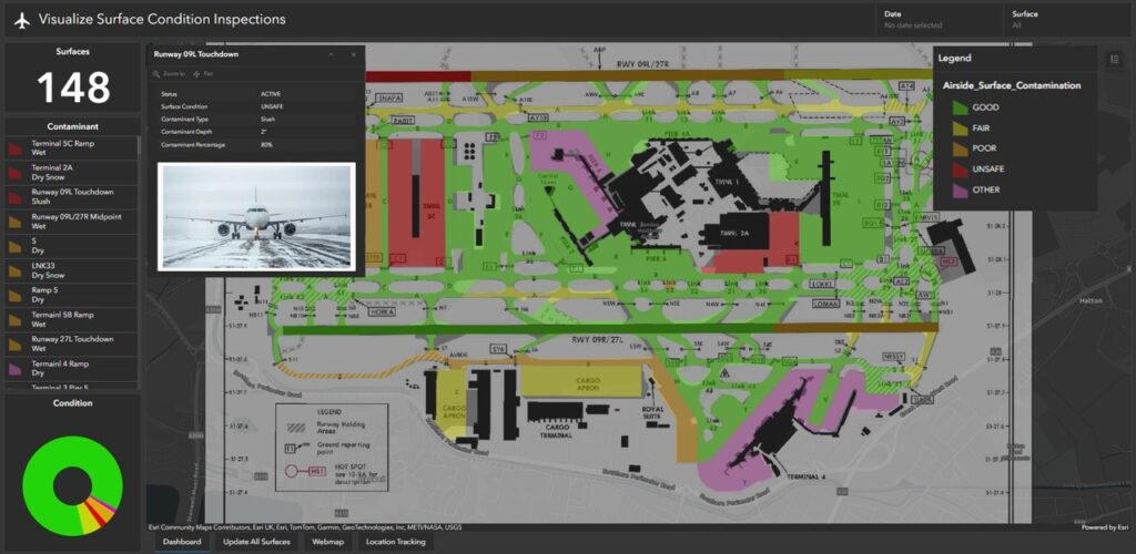
Airside Surface Conditions Dashboard
Expanding on these tools, to help better meet airport’s needs, Esri offers the Winter Weather Operations (WWO) solution, a focused suite of software that supports your airport’s winter weather operations. These tools leverage your investment in ArcGIS technology and your authoritative foundational FAA 18-B airside data to create and refine plowing routes, monitor plowing and treatment activity, collect and share the status of airside surface conditions, and plan seasonal operations.
The WWO solution is powered by ArcGIS Velocity, which enables real-time monitoring and tracking of plows and field crews, can be linked to automatic alerting to individuals and teams, and historical analysis for material tracking and route management. The apps leverage data from AVLs to provide real-time insights and operational efficiency. ArcGIS Velocity supports most common AVL providers out of the box for seamless integration. Field crews use a mobile app to track their locations and progress, report on vehicle service, material usage, and surface conditions.
The WWO solution comprises a suite of applications that can integrate weather data essential for planning and response. Esri partners with various weather providers, such as Baron Weather, which delivers high-resolution, precise data for current conditions and forecasts. Baron’s Radar Mosaic provides near real-time, clutter-free, seamless coverage of North America and updates every two minutes. The Current Pavement Temperature and Road Conditions layers help employees and passengers see if precipitation will stick and if surfaces are wet, icy, or snow-covered when driving to or from the airport. The radar-derived Snow Accumulation layer shows buildup from the past 1 hour to 7 days. Airports can evaluate potential weather-related impacts by utilizing 96-hour, 3km resolution forecast layers for Freezing Rain, Sleet & Snow, and Precipitation Accumulation.
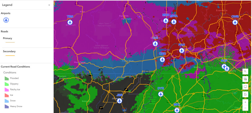
Current Road Conditions
WWO is part of a suite of real-time solutions that can be used to manage maintenance operations. After the ice and snow have melted, airports can use the Mowing Operations solution to help design and improve infield mowing tracks, keep tabs on real-time mowing progress, update mowing status almost instantly, track where mowers are located, and organize mowing tasks to meet FAA wildlife hazard mitigation program requirements. These solutions take a geospatial approach to managing and visualizing operations by facilitating better real-time response coordination, improving operational efficiency, and enhancing communication to ensure safety, efficiency, and compliance.
The challenges posed by increasingly frequent, severe winter weather demand proactive and innovative solutions. Esri’s Winter Weather Operations solution empowers you to anticipate, respond to, and recover from disruptive winter conditions with greater efficiency and confidence. By leveraging real-time data, advanced geospatial analytics, and seamless integration with weather vendors and other operational tools, airports can maintain safer surfaces, optimize resource allocation, and minimize delays. As weather extremes become the norm, adopting a comprehensive, data-driven approach is essential for maintaining operational continuity and delivering a safer, smoother, on-time experience for airport staff and passengers.
Request more information about the Winter Weather Operations solution.
