Air Quality Awareness Week is an annual observance aimed at promoting understanding and awareness about air quality issues. It was established by the U.S. Environmental Protection Agency (EPA) in partnership with the National Oceanic and Atmospheric Administration (NOAA), the Centers for Disease Control and Prevention (CDC), and other government organizations. In recognition of the educational intent of this week, I couldn’t think of a better example of the impact of technology, than the one I learned about myself just a few weeks ago. And since this blog is coming from me, you won’t be surprised to learn that geographic information systems (GIS) technology is a part of the story.
I’m excited to introduce you to the innovative work of Sparrow, a pioneering company leveraging mobile sensors mounted on fleet vehicles to monitor and map urban air quality. In the Q&A that follows, I had the opportunity to speak with Max Interbrick, Co-founder & Chief Operating Officer (COO) of Sparrow, who provides insights into how GIS and environmental intelligence are transforming our approach to air quality and public health.
Este: Can you detail the specific environmental pollutants Sparrow monitors, and why these particular pollutants are a priority?
Max: At Sparrow, our goal is simple: to deliver accurate environmental data while ensuring compliance with government regulations. As urban pollution becomes a growing concern, we provide the information that governments and residents need to make informed decisions.
We specialize in:
- Particulate Matter: We monitor PM10, PM2.5, and PM1—the tiny particles that impact air quality and health.
- Gases: We track key gases like Nitrogen Dioxide (NO2), Ozone (O3), Carbon Monoxide (CO), and greenhouse gases like Carbon Dioxide (CO2) and Volatile Organic Compounds (VOC).
- Atmospheric Conditions: Our systems measure temperature, relative humidity, and atmospheric pressure to provide a more complete picture of the urban environment.
The priority is to identify and define an air quality index (AQI) at the street level with in-depth analytical solutions. Additional parameters such as noise (in dB) and road quality (IRI) complete the Environmental Intelligence picture we offer to help create a cleaner, safer world.
Este: Your work is incredibly timely. The American Lung Association recently shared their 2024 State of the Air report for the United States, finding that 4 in 10 Americans live in places with unhealthy levels of air pollution. What inspired your unique approach of using mobile sensors on fleet vehicles for pollution detection? Can you share the story behind the inception of this idea?
Max: Back in 2020, my co-founder and I were deep into a project working with public transport fleets to implement information systems. It was a promising gig, and we had a solid network. Then, COVID-19 hit, disrupting everything, and forcing us to rethink our strategy. We wanted to leverage our existing relationships with urban fleets, but in a way that would adapt to the new reality.
As we began discussions with city authorities, we were stunned by the lack of information about urban environments within municipalities. It seemed like innovation in these spaces was almost non-existent, and existing solutions fell short of providing actionable data. It became clear that we needed to create something different—something simple to implement, cost-effective for any city, and focused on delivering reliable data and intelligence.
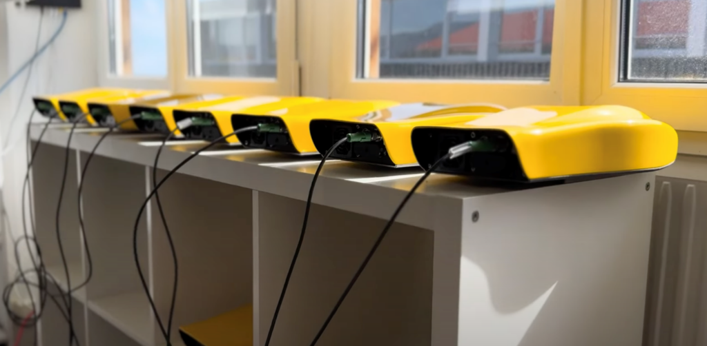
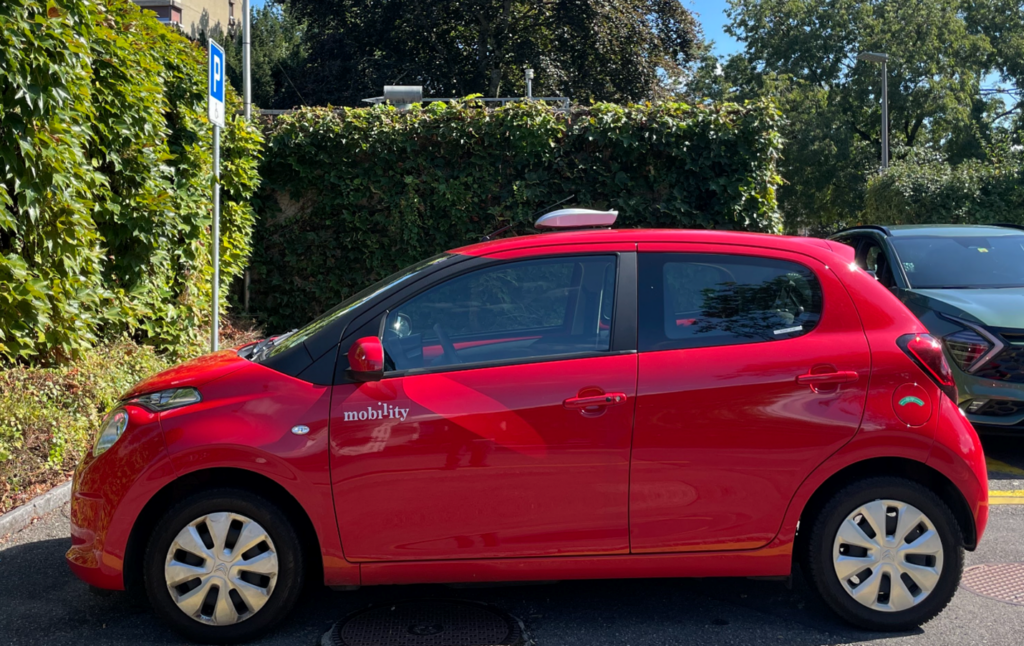
We started by developing our own patent-pending device, the “Sparrow Node.” The concept was straightforward: use public transport as a carrier for these nodes. Buses, taxis, postal vehicles, and more could serve as a mobile network of environmental sensors, providing data at a scale and resolution that static stations simply couldn’t match. With our subscription-based Environmental Intelligence platform, we could offer street-level air quality information to cities around the world.
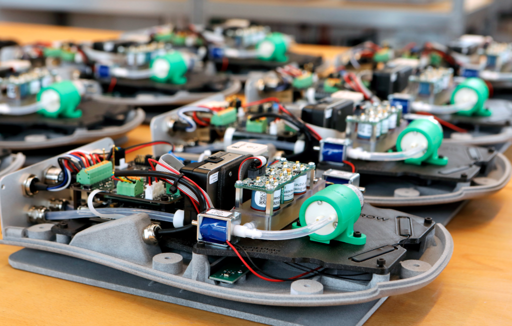
Existing air quality monitoring solutions rely heavily on static stations, which fail to capture the nuances of Traffic Related Air Pollution (TRAP), real-time changes, hotspots, and more. Our approach, using mobile nodes, allowed us to achieve high-resolution measurements down to a 1×1 meter scale, giving cities the data they need to understand and combat pollution more effectively. To ensure accuracy, we collaborated with government stations for calibration and cross-referencing.
The motivation behind our mission was also personal. As a family-oriented team with kids who suffer from allergies, we wanted to create a platform that could be used in any country, city, or neighborhood to improve air quality. Establishing our company in Switzerland, a country known for its commitment to clean air, reinforced our determination to help communities achieve the highest possible standards.
We believe that by making environmental data accessible and actionable, we can help cities take significant steps toward a cleaner, healthier future. Our journey is just beginning, but we’re excited about the impact our platform can have on urban environments around the world.
Este: How does Sparrow integrate GIS technology into tracking and analyzing pollution data collected by your mobile sensors?
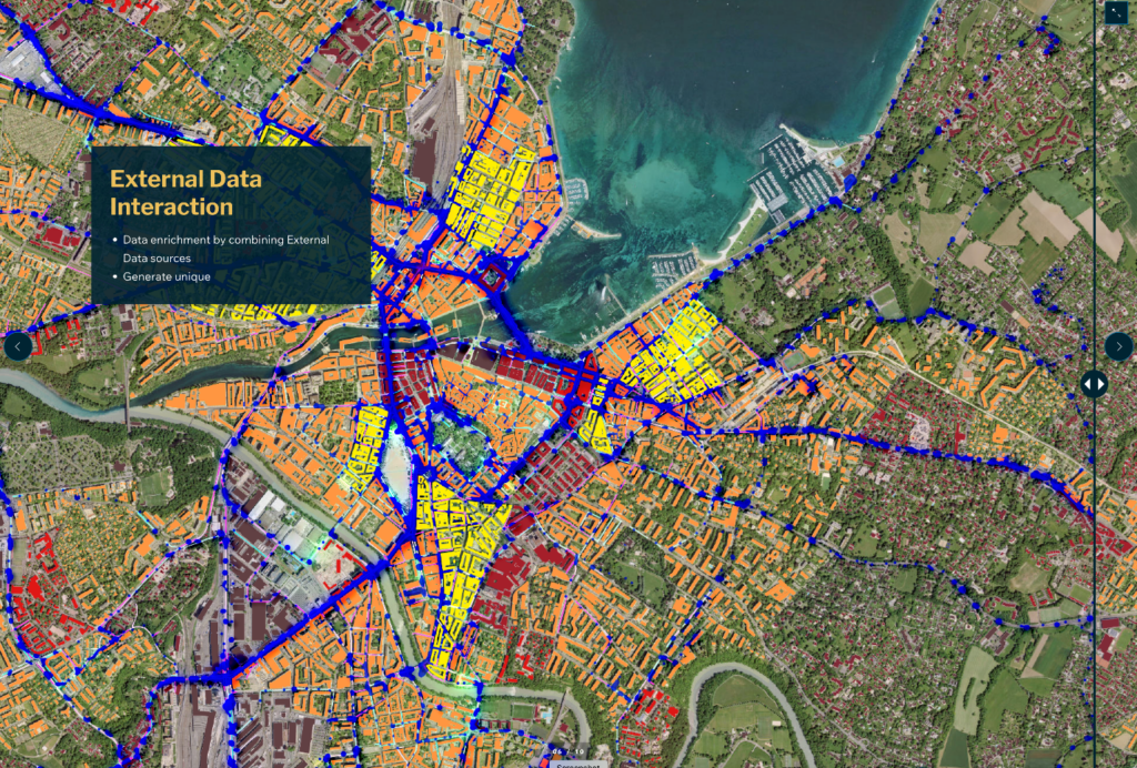
Max: At Sparrow, we have a simple mantra: every measurement point needs two critical parameters—time and GPS position. Without these two elements, our air quality data wouldn’t have much meaning. As a provider of hyperlocal big data, we’re all about maps and geographical placement, which play a crucial role in everything we do. Accurate geographical data allows us to detect pollution hotspots, link them to specific locations, and understand their broader impact—even over distances of more than a thousand miles.
Take, for example, the ability to track pollution dynamics across cities and their surrounding areas. This requires advanced mapping services, and we couldn’t do it without GIS technology. Thankfully, GIS has evolved significantly, with companies like Esri leading the way. Their sophisticated maps, tools, and solutions, when combined with the environmental data we collect with our Sparrow Nodes, offer a comprehensive and highly analytical view of air pollution.
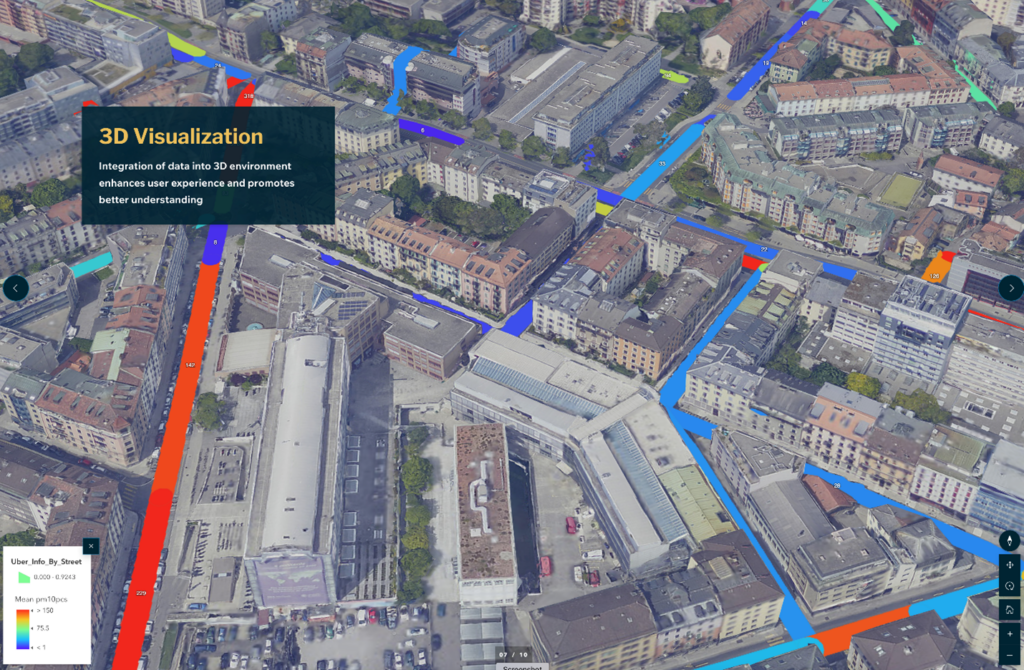
Ultimately, our partnership with Esri and their ArcGIS technology allows Sparrow to provide a unique perspective on air pollution. It’s not just about measuring data; it’s about turning that data into meaningful insights that can drive change. As we continue to expand our reach, GIS will remain an essential tool, helping us create a cleaner, healthier world—one data point at a time.
Este: Could you elaborate on how analytics and AI enhance your capabilities in pollution monitoring and forecasting?
Max: Sparrow’s mission to combat urban air pollution is anything but straightforward. Collecting, processing, and aggregating massive amounts of data demands a sophisticated approach. Luckily, thanks to advancements in CPUs, telecommunications, and modern hardware, we can measure air quality with remarkable precision and stability. But capturing the data is just the beginning. To make sense of billions of data points, we need to get smart. That’s where AI comes in.
Air pollution is an invisible enemy. It’s constantly changing and difficult to control. This is why we’ve embraced AI to help us make sense of the overwhelming amount of data we collect. At the measurement level, AI helps us define and categorize billions of data points, allowing us to create meaningful insights from what would otherwise be a chaotic stream of information. In today’s world, it’s not enough to just measure air quality—we need to understand it at a granular level, identify patterns, and uncover the underlying sources of pollution.
Behind every pollution hotspot in a city, there’s a cause—whether it’s traffic, industrial activity, or something else entirely. AI allows us to create predictive models that help us understand these causal factors and plan strategies to reduce or even eliminate them. This capability is crucial for cities that want to take effective action against pollution.
But AI alone isn’t enough. To make the data accessible and actionable, we need a robust interface that can visualize our insights and bring clarity to complex data for a variety of stakeholders such as city officials, policymakers, and everyday citizens. This is where GIS tools add additional value.
Este: What are some of the major challenges Sparrow has faced while deploying mobile sensors in urban areas, and how have you addressed these challenges?
Max: When we set up our environmental monitoring system in a city, it’s often like stepping into uncharted territory. Urban pollutants are typically measured using a small number of static reference stations or by networks of microsensors deployed by private parties or communities. This limited approach leaves cities and their residents largely in the dark about air quality at the street level. Over the past three years, we’ve run pilots in more than 10 different cities, using a diverse range of public transport, from city fleets and street sweepers to garbage trucks, buses, and taxis. These experiences have taught us that each type of transport has unique potential for collecting data.
But building these urban networks isn’t without its challenges. Here are the major hurdles we face:
- Collaboration with Local Authorities: Working closely with municipalities and environmental agencies is crucial for validating our data and developing trust.
- Selecting the Right Fleets: Choosing the best public transport for phased implementation requires careful planning and flexibility.
- Providing Data Access: We aim to make our data available to public and private entities, as well as to city dwellers, but this requires robust systems for sharing information.
To overcome these challenges, Sparrow has developed a unique approach that combines reliable, precise devices with a flexible implementation model. Our technology is always open to validation against existing city stations, ensuring accuracy and credibility. For public transport fleets, we offer an attractive monetization model, which has already been embraced in Switzerland, where we’re partnering with postal services. The model creates a win-win situation where public fleets get a new revenue stream and we get valuable live-streamed data.
We also take an active role in international bodies like the International Telecommunication Union (ITU) Study Group 20 (SG20), the United Nations Environmental Program (UNEP), and Universal Postal Union (UPU), allowing us to represent our technology on a global scale. UPU, for instance, manages nearly 1 million postal vehicles worldwide, providing an excellent opportunity to set up initial data collection networks in cities.
As we move forward, we’re excited to expand into new markets. This year, we’re planning to enter the USA, Asia, the Middle East, and Latin America. Each of these regions presents unique opportunities and challenges, and we can’t wait to bring our environmental intelligence approach to new urban areas.
Este: How has the pollution data collected by Sparrow been utilized by different stakeholders? Can you provide examples of how this data has influenced urban planning, public health, or healthcare initiatives?
Max: For years, air quality data was the domain of experts. Environmental agencies and academic researchers limited access to sensitive information, keeping it away from the public eye. But today, with climate change and urban pollution in the spotlight, there’s a growing demand for environmental data from both the public and private sectors.
Sparrow is meeting this demand by offering accurate air quality data in a way that’s accessible to everyone. No longer just for government agencies, our data is now valuable to a variety of industries, including health, real estate, tourism, insurance, and more. We’re seeing businesses use our insights to improve existing products and create new ones.
Think about a typical day in the city: walking to work, taking public transit, or bringing your kids to the park. You’re constantly exposed to pollution, and even indoor air quality can be affected by outdoor conditions. Sparrow’s goal is to provide data that helps people make informed decisions about their personal exposure to environmental pollution. Here are a few examples:
- Citizens: With Sparrow’s hyperlocal data, sensitive individuals can adjust their daily routines to minimize exposure to triggers. For example, they can choose safer routes for jogging or cycling away from high-pollution areas. They can answer important questions like, “Where is the environment healthier for my aging parents with cardiovascular or respiratory conditions?”
- Governments: Sparrow’s data helps local authorities improve urban planning. By pinpointing pollution hotspots, they can create healthier environments through better traffic management, more green spaces, and stricter air quality controls. These data support many decisions such as where large vehicle access should be restricted or where trees should be planted to aid in air purification.
- Businesses: Companies can use Sparrow’s data to meet customer needs and support urban sustainability. This benefits sectors like health, real estate, and tourism, positioning businesses as key contributors in the fight against urban pollution. Companies want to gain insights that will help them reduce greenhouse gas emissions or improve absenteeism from health concerns related to poor air quality.
By connecting citizens, governments, and businesses, Sparrow creates a collaborative approach to improving city health and livability. We believe everyone should have the information they need to reduce their exposure to pollution, regardless of income or background.
With Sparrow, we’re building a bridge between complex data and practical solutions, empowering people to live healthier, cleaner lives by making air quality data more accessible and meaningful.
Este: Can you discuss any key partnerships that have been instrumental to your project’s success? How does collaborating with companies like Esri enhance your operations?
Max: Cities are like living organisms, where everything from urban planning to mobility is interconnected and constantly evolving. To keep pace with this complexity, Sparrow relies on a network of collaborative partnerships. Our mission to measure and map air quality in cities wouldn’t be possible without close cooperation with various stakeholders.
Each time we detect urban pollution, a validation process follows that requires strong relationships with environmental agencies and municipalities. This ensures that our data is accurate, credible, and aligned with local regulations. But it’s not just about compliance. To operate effectively, we need a robust infrastructure for data transfer, processing, and storage.
This is where partners like Swisscom, AWS, and Microsoft come in. Swisscom provides the backbone for our real-time data transfer via 5G, allowing us to send vast amounts of information quickly and reliably. AWS handles our big data processing and storage, ensuring we have the capacity to manage and analyze the enormous volume of air quality data we collect. Microsoft also contributes their own unique services, helping us build a robust technological foundation.
One of our most significant partnerships is with Esri, the company behind the ArcGIS platform. Those tools enable us to create detailed geographic representations of air quality data, providing invaluable insights for city planners and residents alike. Esri’s platform and marketplace also open up new opportunities helping us offer our data to a broader audience, so other companies and developers can build innovative applications on top of our information.
Collaboration is at the heart of what we do. By establishing strong partnerships with technology providers, environmental agencies, municipalities, and others, Sparrow can achieve its mission of delivering precise air quality measurements and actionable insights to cities around the world. These partnerships not only enable us to gather and process data effectively but also ensure that our work has a meaningful impact on urban environments.
Este: Are there new technologies or methodologies that Sparrow is looking to adopt in the near future to enhance pollution detection and analysis?
Max: While all cities share common measurement needs for pollutants like PM10, PM2.5, NO2, and O3, each city has its own unique characteristics, requiring a tailored approach.
We’re not just about air quality measurements; Sparrow’s platform is designed to be adaptable and comprehensive. We currently measure over 25 parameters, covering air pollution, noise exposure, and road quality. In the near future, we plan to add thermal imaging to scan building facades for energy leaks, helping urban real estate owners save millions on heating and reducing greenhouse gas emissions. We’re also exploring additional sensors for SO2, propane, and butane detection, based on market demand and client requests.
This flexibility is one of Sparrow’s strengths. Once we validate a need for new measurements, we can quickly bring them to market. Our platform is designed to evolve with the changing demands of urban environments, ensuring that our data stays relevant and valuable.
The unique DNA of each city means we must be agile and responsive to local needs. Some cities might require more focus on air pollution, while others need greater emphasis on noise or road quality. By customizing our approach, we can provide cities with the specific data they need to make informed decisions about public health and safety.
Este: What are Sparrow’s plans for scaling up or expanding into new markets or regions in the coming years?
Max: Sparrow’s vision is ambitious but clear: we see ourselves as a global force, providing large corporations and governments around the world with vital environmental data. Our focus this year is on expanding our reach to as many cities as possible and identifying key areas for future deployments.
Sparrow aims to bring air quality data to the places that need it most—especially low-income areas suffering from severe air pollution. Such communities often lack the resources for expensive air quality setups and need real data, not just simulations.
To reach these areas quickly, Sparrow has partnered with the United Nations Environment Program (UNEP) and the Universal Postal Union (UPU). These partnerships allow us to work with postal services worldwide, enabling our air quality measurement nodes to be deployed in just about any community.
Our goal is to ensure everyone, regardless of income, has access to accurate air quality information. By working with UNEP and UPU, we’re expanding our reach into regions that often get overlooked. We want every community to have the opportunity to use real data to inform local policies, improve public health, and raise awareness about air pollution’s impact.
We’re committed to a future where everyone can breathe clean air, and we believe that accurate data is the first step in making that a reality. By focusing on low-income areas and collaborating with global organizations, Sparrow is taking concrete steps toward a more equitable and sustainable world.
Este: How does Sparrow engage with the public or local communities to raise awareness and educate them about air quality issues?
Max: Sparrow’s aim to provide hyperlocal air quality data is more than just a technical challenge—it’s about empowering city residents to understand and assess their personal exposure to air pollution. To achieve this, we rely on community engagement, education, and a strong presence on social media. Our goal is to create a movement where every city has its own “flock of Sparrows,” collecting and sharing valuable air quality data.
To spread the word and raise awareness, Sparrow uses multiple channels. We work with city governments, community organizations, and local influencers to promote our message. But we know it’s not enough just to share information; we also need to make air quality data accessible and engaging. That’s why we’re organizing hackathons, street projects, and other interactive events to encourage people to get involved with our platform.
One of our upcoming projects, “Every City Must Have Its Flock of Sparrows,” aims to involve the youth in our mission. By engaging young people, we tap into a passionate and tech-savvy demographic that’s eager to make a difference. We plan to incentivize participation with rewards and recognition, encouraging local residents to use Sparrow data in creative and meaningful ways. This might include school projects, public art installations, or community-led air quality monitoring.
To ensure our efforts have a lasting impact, Sparrow is also focusing on education. We work with schools and community centers to provide educational resources about air pollution, its effects on health, and ways to reduce personal exposure. By building a knowledgeable and informed community, we believe we can inspire action and drive change.
Ultimately, our aim is to create a grassroots movement that transforms the way people think about air quality. By promoting awareness and providing the tools to measure air pollution at a hyperlocal level, Sparrow is giving city residents the power to take control of their environment. Whether it’s through social media, local events, or educational initiatives, we’re committed to making clean air a priority for everyone.
Thank you, Max Interbrick. It’s clear from our discussion that as cities continue to grow and evolve, the challenge of managing urban air quality becomes increasingly complex.
Through their innovative technology and strategic partnerships, we see Sparrow at the forefront of a movement that not only measures but actively improves urban air environments. Their work exemplifies the power of combining advanced technology with geographic insights, offering a beacon of hope for healthier urban living. This Air Quality Awareness Week, let’s reflect on the strides we’ve made and the journey ahead, as we aim for a cleaner, more sustainable future for all urban dwellers.
If you’d like more information about Sparrow’s work or Esri’s ArcGIS technology, please reach out to us at healthinfo@esri.com.