For the past couple of years, most of my blogs and presentations have centered on my excitement around the Bipartisan Infrastructure Law (BIL), the Inflation Reduction Act (IRA), and the opportunities that they afford the environmental community, and of course – how GIS can help us create the world we want to see.
As 2023 came to a close, I increasingly began to think about this moment in a historical context. At the 2023 Natural Areas Conference I delivered the closing plenary where I reflected on this more. For me, 2023 was a year of significant change, having moved into a new home in a new state. This home was built in the early 60’s and required a total renovation, and as we began to renovate it, I noticed some interesting features!
Specifically, the doorbells had an interesting medallion on them stating that this was a Gold Medal Home with the slogan “Live Better Electrically.” As I researched this, I learned it was a 50’s and 60’s era marketing campaign by the electric industry. At the time, demand for electricity was stagnant even though dams were being built at a feverish pace. The goal was to derive a marketing campaign that touted the benefits of moving away from burning coal in the home to having an all-electric house and increase demand. This was the era of the Jetsons after all!
The interesting thing to me about this is that we can agree that building dams has had a significant negative impact on our environment, yet, moving away from burning coal in our homes has had a positive impact on our environment and our health. This is a similar conundrum that we face today as we understand the urgency to move towards clean energy while ensuring that our solar campuses, wind farms, and nuclear technologies aren’t adversely impacting our environment.
Celebrating 50 Years of the Endangered Species Act
Part of what has me waxing on the historical context of the BIL is the fact that December 28th, 2023 marked the 50th year of the Endangered Species Act (ESA). The era of my Gold Medal Home was an interesting one leading up to the passage of the ESA, NEPA and the establishment of CEQ and EPA by the Nixon Administration. It was rife with public outcry for our government to address mounting issues of industrial pollution, and the Nixon Administration knew it was politically savvy to pass this landmark suite of environmental legislation that is still foundational to our environmental policies today. In fact, looking back even further at the first wave of environmental policy in the US, we can look at Roosevelt and the Conservation Era and recognize that that too was driven by public recognition that industrialization threatened to overtake our natural world. It took nearly 70 years between the Roosevelt Era’s American Antiquities Act to pass the Nixon Era’s ESA and the NEPA. In that time, we can see that our understanding of our role in our environment has become increasingly holistic. By that metric, maybe we are due for another environmental revolution? One that codifies this increasingly holistic understanding. Can we look to the BIL to deliver clues to what that may be? And how, as environmental GIS professionals, do we leverage tools to help bring understanding to what was, what is, and what could be?
GIS Resolutions for the New Year
Something we have now that the Roosevelt and Nixon Administration’s lacked is advanced and emerging technologies. When dams were being built and new power plants being brought online, it was difficult to see across a landscape at scale and understand what these impacts would or could be. As we face similar challenges in the modern day, coupled with increasing challenges due to climate change and various familiar foes, we have GIS to help us analyze and understand increasingly complex issues about how our environmental, economic and social systems interact and respond to one another.
It seems appropriate then that in this New Year, following the anniversary of the passage of the world’s most revolutionary environmental laws, we can take inspiration to ensure that our passion for our environment and our responsibility in ensuring its sustainability and resiliency is coupled with our ability to leverage the most modern and cutting edge tools to tackle the increasingly complex challenges we face. To get you on your path, I’m presenting a few “GIS Resolutions for the Environmental Professional.”
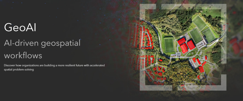
Resolution 1: I Will Accelerate My Work With GeoAI
“May we live in very precedented times” has been one joke floating around online in meme-land. Yet, as environmental professionals, we know that this won’t be true any time soon. We are experiencing climate change with increasing velocity and greater impact. Coupled with this, is our constant pressure to “do more with less.” Our community has already begun to embrace GeoAI through habitat niche modeling and other kinds of predictive analysis, but wait, there’s more! GeoAI continues to advance, and we have an opportunity to lean into it and expand our imaginations with how we apply it to meet these very unprecedented times. GeoAI helps environmental professionals by:
Enhanced Data Analysis: GeoAI enables the analysis of large geospatial datasets, providing insights into environmental patterns and trends. This can help identify areas of high pollution, monitor changes in land cover, and assess the impact of human activities on ecosystems.
Improved Decision-Making: By leveraging GeoAI, environmental professionals can make more informed decisions. AI algorithms can process complex environmental data and generate predictive models, helping to identify potential risks, optimize resource allocation, and support sustainable planning and management practices.
Efficient Monitoring and Surveillance: GeoAI allows for real-time monitoring and surveillance of environmental conditions. It can automate the analysis of satellite imagery, sensor data, and social media feeds to detect and track environmental events such as wildfires, deforestation, or pollution incidents. This enables timely responses and interventions to mitigate environmental risks.
Conservation and Biodiversity Management: GeoAI can contribute to conservation efforts and biodiversity management. It can assist in habitat mapping, species distribution modeling, and ecological niche analysis. By combining AI techniques with geospatial data, environmental professionals can gain valuable insights into ecosystems and develop strategies for preserving biodiversity and protecting endangered species. Better yet, much of these capabilities you likely already own in your GIS stack! To learn more and get started, visit the Esri GeoAI page.
Resolution 2: I Will Embrace Earth Observation and Remote Sensing Technologies
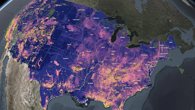
Just this morning before writing this, I was reading a new paper out of Northern Arizona University discussing how the use of satellite technology (specifically GEDI from NOAA) allows us to monitor biodiversity remotely by using 3D forest structure to better model relationships between structure and biodiversity. Research of this kind and exploring the possibilities of these datasets is only going to continue to improve. In fact, it will be a significant component of Resolution 1 above, as it allows us to ask questions at… yes… an unprecedented scale! The kind of precedent I like! Environmental GIS professionals can gain quite a lot by refreshing their skills and knowledge in this arena. Take the following for example:
Enhanced Data Collection: Earth observation and remote sensing technologies provide a wealth of data about the Earth’s surface, atmosphere, and oceans. These technologies enable environmental professionals to collect vast amounts of data quickly and efficiently, covering large areas that would be otherwise challenging to survey. This data can be used to monitor environmental changes, track biodiversity, assess land use, and much more.
Improved Analysis and Monitoring: Earth observation and remote sensing technologies offer advanced tools for analyzing and monitoring environmental conditions. By utilizing satellite imagery, aerial photography, and other remote sensing techniques, environmental professionals can gain valuable insights into various environmental parameters. They can detect changes in vegetation cover, monitor water quality, identify pollution sources, and assess the impact of human activities on ecosystems.
Early Warning Systems: Earth observation and remote sensing technologies play a crucial role in developing early warning systems for natural disasters and environmental hazards. By continuously monitoring the Earth’s surface and atmosphere, these technologies can detect signs of impending disasters such as wildfires, floods, and hurricanes. This early warning capability allows environmental professionals to take proactive measures to mitigate the risks and protect communities and ecosystems.
Support for Decision-Making: Earth observation and remote sensing technologies provide valuable information to support decision-making processes in environmental management. By integrating satellite data, GIS (Geographic Information System) tools, and other analytical techniques, environmental professionals can make informed decisions about resource allocation, land use planning, conservation strategies, and disaster response. These technologies enable them to visualize and analyze complex spatial data, facilitating evidence-based decision-making. To get started, check out these Imagery and Remote Sensing Fundamentals training!
Resolution 3: I Will Learn to Gain Insight Instantly with Real-time Feeds
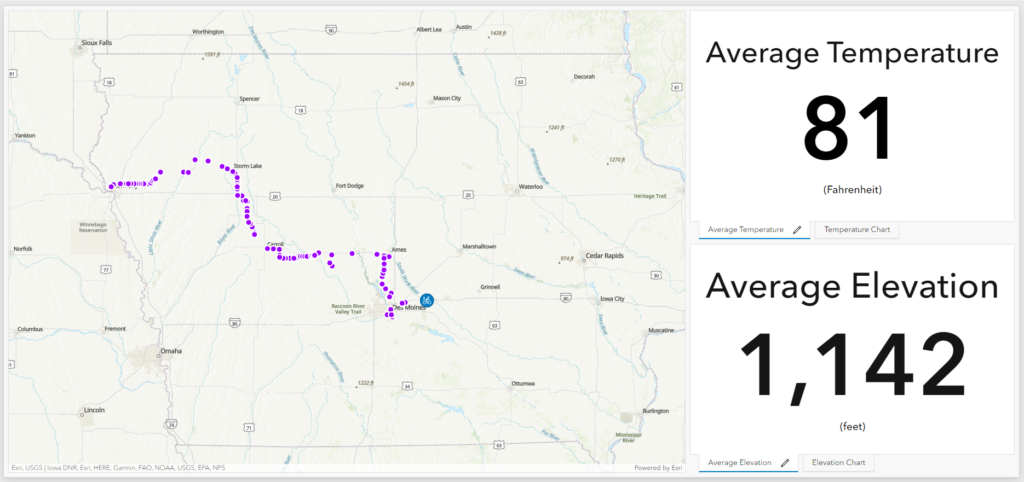
One of my favorite memories from 2023 was when our new Esri Partner, Vectronic, clipped one of their new wildlife collars to the back of their bicycle and biked across the state of Iowa pretending to be an animal “herd.” Back at Esri HQ, the ArcGIS Velocity product team automatically streamed in the collar/bicycle/herd feed to an ArcGIS Dashboard, and enhanced the feed with other metrics like weather conditions and elevation. This new partnership opens up a plethora of possibilities for our community of wildlife managers! Yet, the opportunity to revolutionize the work of all environmental professionals is also available. Our world is now covered with various sensor networks, and it’s important that environmental professionals of all kinds take advantage of this technology. Air pollution, water quality, weather and even social media trends can be brought into our GIS through ArcGIS Velocity to help us do amazing things for our environment and our communities. Consider that real-time data can help environmental professionals:
Timely and Accurate Data: Real-time sensor networks provide continuous and up-to-date data on various environmental parameters such as air quality, water quality, weather conditions, and more. This data is crucial for monitoring changes, detecting anomalies, and responding quickly to environmental events. With real-time data, professionals can stay informed about the current state of the environment and take appropriate actions.
Early Warning Systems: Real-time sensor networks enable the development of early warning systems for natural disasters, pollution incidents, and other environmental hazards. By detecting changes in sensor readings, professionals can anticipate and mitigate potential risks. This proactive approach helps protect communities and ecosystems by providing advance notice and allowing for timely response and intervention.
Improved Decision-Making: Access to real-time data from sensor networks empowers environmental professionals to make informed decisions. They can analyze trends, identify patterns, and assess the impact of interventions or policies in real-time. This supports evidence-based decision-making, leading to more effective environmental management and conservation efforts. Real-time data allows professionals to evaluate the effectiveness of their actions promptly and adjust as needed. Learn more about ArcGIS Velocity here.
Resolution 4: I Will Communicate My Knowledge At Scale with Modern Web-GIS
Last but not least, communication and collaboration. When I spoke about the public demand that led to the Nixon Administration’s passage of the ESA and NEPA, one of the most widely recognized and influential texts of that time was Rachel Carson’s “Silent Spring.” This book was the communication tool of its time, and was wildly successful in galvanizing the Environmental Movement. We now live in a digital world and therefore our communication needs to meet people where they’re at. Environmental professionals have long embraced GIS tools, and as the technology evolves to take advantage of the cloud, so too should our skills. Out of all four resolutions, this one is the easiest to tackle.
As we conduct amazing analysis on our desktops and discover key insights, it’s even more important to effectively communicate and help interpret the results to a wide variety of stakeholders. It is simply not enough to publish the data, but we must begin to leverage ArcGIS Experience Builder and ArcGIS Dashboards to summarize the results, use ArcGIS Story Maps to help walk people through the bigger picture, and embrace the power of ArcGIS Hub to help communities take effective local action. You also won’t want to miss this free Esri online course, Going Places with Spatial Analysis, which will explore how the special capabilities of spatial data analysis provide deeper understanding and give you hands-on experience with authentic spatial analysis workflows in a cloud-based mapping environment.
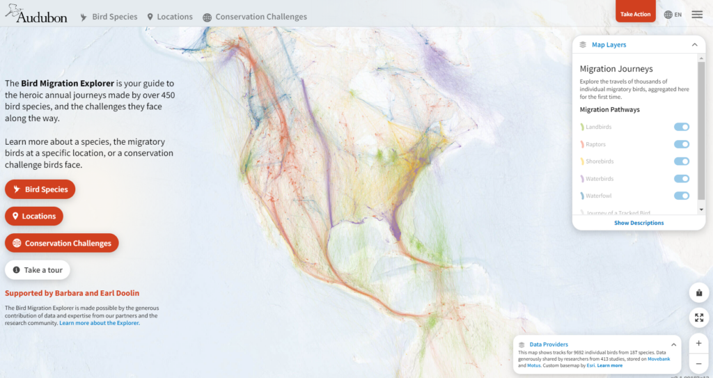
Using engaging, interactive and beautiful maps goes a long way in connecting with audiences about complex global topics and how they relate to individuals in their own communities. One of the most powerful examples of this in early 2023 was Audubon’s interactive bird migration website going viral.
Cheers to 2024! I fully expect to see our community of environmental professionals embrace these modern technologies, accelerate the impact of your work, and create the world you want to see.