In 2022, the Littlerock Creek Irrigation District (LCID) began the development of a new geographic information system (GIS) program. This GIS program would allow the district to comply with new requirements while building a database of asset locations and sharing critical asset location information with the LCID operations staff.
The LCID is a special district in northern Los Angeles County that serves approximately 1,400 customer connections. The district was formed nearly 170 years ago to provide irrigation ditch water to orchards in Littlerock, the “fruit basket of the Antelope Valley.” Today, the majority of LCID customers are served with potable water that is delivered through a network of distribution mainlines, a majority of which were constructed in the mid-1900s.
Challenge
The LCID service area is located within the western Mojave Desert. Due to the desert climate, there is a constant accumulation of sand and dirt on and alongside the unpaved roads. Distribution system components, particularly valve boxes, quickly become buried. During routine valve exercising or in an emergency, distribution system operators often must use a metal detector to locate valve covers. It has historically been a time-consuming process for district operators to locate and uncover buried valves and related pipelines for repair and maintenance. District operations staff have relied on prior system knowledge and paper as-built record drawings from various mainline construction projects to locate distribution system assets.

On January 1, 2022, a bill (CA Government Code 4216) was passed in California that required all water utilities to leverage a geographic information system to record the location of newly constructed distribution system assets. In response to this new bill, LCID general manager James Chaisson led the district to invest in the development of a system-wide GIS program. The LCID did not have any GIS data before this program. The LCID retained MC Engineering, Inc., to develop an initial system-wide asset database and an interface for district staff to access the GIS on an iPad.
Chaisson has indicated that a key factor in becoming a manager was taking the time to thoroughly understand the LCID distribution system. While working as an operator, he personally exercised nearly every distribution system valve. All the LCID team members take great pride in learning more about their system, and they say this process is a journey. Even after years of working at the district, new information is continuously being discovered.
The LCID needed a central repository for editing and reviewing information, capturing historical institutional knowledge regarding the system, and recording new asset locations and maintenance information.

Partner
MC Engineering is a civil engineering firm in California that focuses on serving municipal water and wastewater systems. The MC Engineering GIS team serves as an extension of water and wastewater utility staff in the development and maintenance of GIS programs. MC Engineering also provides engineering design, construction management, and grant acquisition services. The company specializes in supporting small and midsize utilities.

Solution
LCID worked with MC Engineering to develop a utility GIS program that would become the authoritative source of system-wide asset information. In addition, GIS-based applications were configured to provide staff access to GIS via their iPad devices.
MC Engineering began this project by scanning all available LCID distribution system record drawings and saving the PDF images in a geographically rectified format in ArcGIS Online. A web application was developed to enable district staff to access the record drawings. Staff can open the web map and click on a polygon (rectangle) in the vicinity of interest, and this will open up the related record drawing. The app allows district staff to carry all related record drawings on their iPad and quickly access the drawings in a specific area.

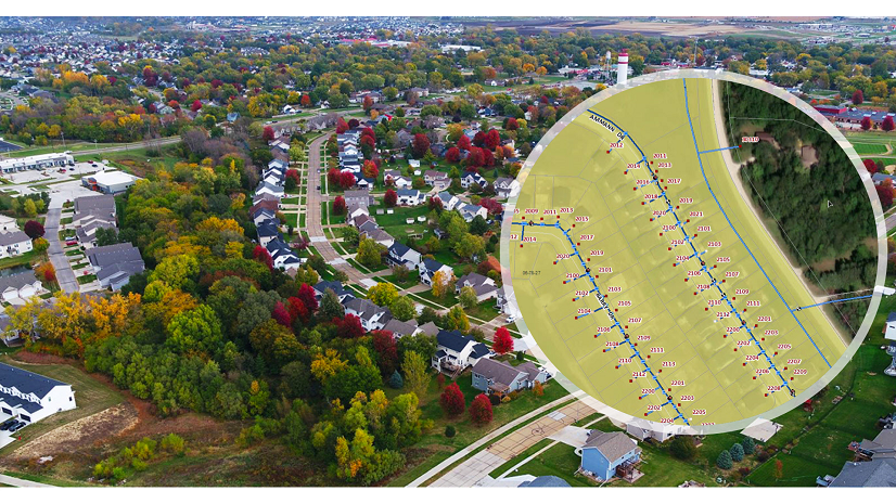
In tandem with this effort, MC Engineering conducted a high-resolution (3 cm) fixed-wing aerial survey over nearly the entire 5,000-acre LCID service area. Aerial targets were strategically placed by a licensed land surveyor throughout the vicinity to allow the aerial images to be georectified.

The high-resolution aerial photos were processed with Esri ArcGIS software to capture the location of aboveground distribution system assets, with accuracies within inches of deviation. Mainline locations were estimated by comparing information shown on record drawings to geographic features shown in the aerial images. The resultant distribution system asset database was saved in ArcGIS Online, which was configured to allow district staff to access the asset locations on a mobile device in the field. The LCID purchased an Eos Positioning Systems Arrow Gold Global Navigation Satellite System (GNSS) receiver for recording the location of assets that were not visible during the initial aerial survey. This high-accuracy receiver enables staff to locate assets within one centimeter.
The LCID distribution operations team was eager to provide feedback and fill in areas of the district that were missed in the initial aerial survey. MC Engineering staff conducted several one-day workshops with LCID staff to introduce the Eos GNSS receiver and Esri’s ArcGIS Field Maps, and a final two-day workshop to correct upgrades and improvements to the system that were not documented. Discrepancies between the GIS database and old and outdated district prints were resolved based on staff knowledge.

Result
LCID staff now have access to asset locations and related information both in Esri Field Maps on a mobile device and through web applications that are accessed through a central website. Staff can view record drawings, view asset locations, and add new asset locations to the GIS.

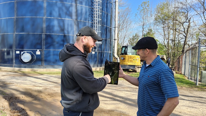
Steven Rafferty, the LCID distribution operations foreman, says that the new tools and asset database have simplified his work. He is now using the record drawing organization tool multiple times per week, and he often uses the asset viewing tool to get a quick look at what he is working on or looking for. On multiple occasions, the GIS program has come in handy, using the GIS data on an iPad to find valves that were already mapped with the aerial survey and are now buried. The Eos GNSS receiver enables staff to locate a place to dig for pipeline repairs with nearly perfect accuracy. When assets in the vicinity are buried, this typically saves the operators 5–30 minutes—or, in some circumstances, hours—of locating time.
The district has completed an aerial survey as well as initial mapping of system gate valves, hydrants, hydrant valves, and mainlines. This new GIS mapping database is leveraged to record asset locations and information, monitor asset maintenance (for example, valve exercising), and plan for long-term asset management activities. This asset database has enabled the district to both comply with CA Government Code 4216 requirements and improve operational efficiencies. Staff are spending less time locating and relocating assets and more time maintaining the system.
The district plans on expanding the GIS to include water meters and blow-off points. The GIS database will be continuously used to record new construction projects. The district will also continue to refine the recorded locations of select assets that were constructed over 100 years ago with no plans on record. The GIS information gathered is developing the knowledge of current and future district staff and will streamline operator training.
Chaisson had a good experience working with MC Engineering on this project. “The experience working with MC Engineering was top-notch. MC Engineering was always there to answer any questions with professional answers. MC Engineering was helpful with gathering the information needed for the implementation of the GIS system,” Chaisson said.
Stay Connected with Esri’s Water Team
ArcGIS is an extensive information system that enables modernization of workflows with easy-to-use applications for the field and office. Strengthen your organization with smart water solutions that will increase efficiency and provide insight for decision-makers. Visit the Esri Water Utilities web site for more information.
Join the Water Utilities Community
Follow #EsriWater on social media: X | LinkedIn
Subscribe to the Water Industry newsletter “Esri News for Water Utilities and Water Resources“
Learn more about how Esri supports rural and small water.
About the author