By: Rui Leite, GIS Coordinator, Águas do Norte
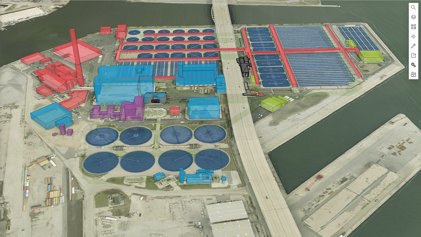
Águas do Norte is a water supply and sanitation utility in Portugal that is responsible for managing two systems. The utility’s conveyance system is responsible for the collection, treatment, and transport of water and the collection, treatment, and rejection of domestic and urban domestic and urban wastewater in 63 municipalities. Staff operate and manage the distribution and collection system, providing water distribution and basic sanitation services in eight municipalities.
Águas do Norte has been using geographic information system (GIS) technology as a core component of its operational architecture for approximately a decade. The utility has progressively enhanced existing solutions by adopting ArcGIS Utility Network.
Aguas do Norte’s vision is to maximize the benefits of ArcGIS by creating GIS-enabled business systems—in other words, to use GIS web services to extend the functionalities of existing business systems. These systems include enterprise asset management (EAM), operations and maintenance, dam management, alarm center, BI platforms, and customer relationship management (CRM), adding geolocation, mapping, and spatial analysis capabilities.
Challenge
Designing a strategy for integrating GIS with the company’s business systems was challenging. Águas do Norte focused on applications such as asset management, commercial operations, maintenance, infrastructure operations, dam monitoring, key performance indicators (KPIs), and balanced scorecard systems.
The strategy needed to include enabling bidirectional data flows, specifically to receive and process georeferenced events reported within these applications—water leaks, maintenance interventions, and other operational incidents.
Solution
The migration to ArcGIS Utility Network allowed us to fully represent our complex water networks, model assets in more detail, and take advantage of the service-based architecture. After this first step, which took us a couple of years, the integration with other systems was our next priority.
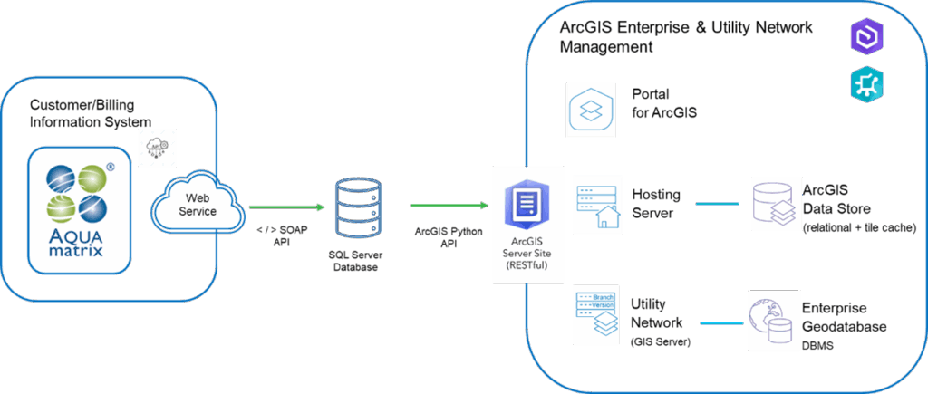
Our integration strategy with ArcGIS Utility Network centers around exposing ArcGIS REST API to internal systems—such as EAM, dam management, and operations and maintenance (O&M) platforms—while enabling authenticated editing capabilities for selected users and systems.
These data inputs are further enriched within the GIS environment by being associated with network metadata such as district metered areas (DMAs), pressure zones, pipe material, and diameter. We utilize ArcGIS API for Python to automate enrichment, validation, and geoprocessing workflows.
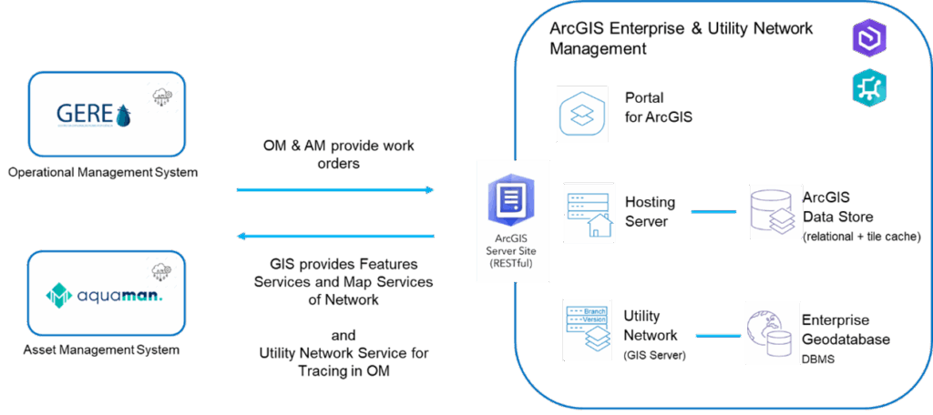
Another key integration example involves synchronizing commercial data from our CRM platform, using the CRM’s native API to extract records and populate a transitional SQL database through a structured extract, transform, and load (ETL) pipeline. This allows us to store, normalize, and manipulate high volumes of customer data without compromising the original data. It also enables the advanced querying and generation of spatially aware business insights through customized dashboards and reporting layers.
Results
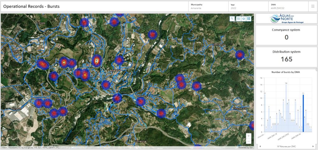
The structuring of both commercial data (e.g., customer profiles and consumption) and operational data related to water leaks—combined with the use of APIs to obtain additional network attributes such as DMAs and pressure zones—has made it possible to enrich GIS layers with contextual information and automate key business processes.
Through the visualization of pipe burst events along with the contextual attributes provided via APIs, we can now efficiently update our linear asset register—specifically, fields such as pipe material and diameter—based on real-time or near real-time operational data captured by business applications. Furthermore, this architecture supports advanced querying capabilities, allowing us to analyze failure rates per DMA and assess the temporal distribution of water leaks by month across the years, providing actionable insights for both operational response and strategic planning.
“The primary objective of a geographic information system is to deliver geographical context and decision-making capabilities to the business. To maximize return on investment and accelerate value delivery, Águas do Norte has strategically aligned its GIS initiatives with this vision, ensuring that business operations across departments benefit from enriched geospatial data and increased process efficiency.“
The adoption of Utility Network, with its advanced capabilities available via web services, has enabled functionalities such as generating web-based network maps that support isolation tracing in the event of service disruption, as well as exporting the network dataset to water modeling platforms—complete with validated topology and node-level consumption distribution.

Stay Connected with Esri’s Water Team
ArcGIS is an extensive information system that enables modernization of workflows with easy-to-use applications. Strengthen your organization with GIS-based solutions that will increase efficiency and provide insight for decision-makers. Visit the Esri Water Utilities web site for more information.
Join the Water Utilities Community
Follow #EsriWater on social media: X | LinkedIn
Subscribe to the Water Industry newsletter “Esri News for Water Utilities and Water Resources“