Implementing a Long-Term Asset Management Strategy
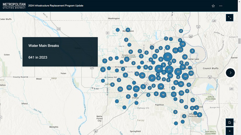
Covington Water District provides clean, safe, and reliable drinking water to a 55-mile area in south King County, Washington. It serves a population of more than 50,000 through 19,000 utility connections. The district is responsible for 90,000 water assets, including 324 miles of transmission and distribution pipe.
To understand and track its water network, the district previously relied on CAD paper drawings and quarter-section maps of underground assets, often using historic data to estimate system connection points. Covington Water managers determined that the maintenance of the CAD drawings was ultimately inefficient, and Esri tools were the chosen way of the future. The district knew it needed a strategy for its geographic information system (GIS) to clean up data, access as-built drawings quickly, produce comprehensive maps, make informed infrastructure decisions, and ultimately save time and costs.
Transforming Data for a Modern Network
In 2009, Covington Water purchased its first Esri GIS server license and new GPS units to revamp utility mapping. The purchase led to a digital transformation for the district. From 2010 to 2022, the district made additional software investments, cleaned its historic data, and converted files from hard copy to digital.
“It was an interesting process and long journey,” said Mike Velasco, Covington Water District GIS coordinator and GIS program originator at Covington Water. “We were digitizing historic information into the system, and we were also keeping the system up to date and live with new data along the way.”
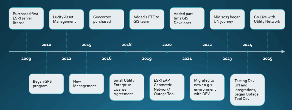
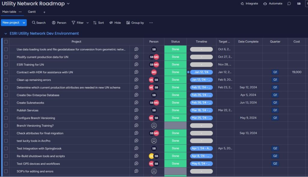
The agency used ArcGIS Server and Portal for ArcGIS as two separate internally hosted servers to store and process information. In 2022, the mapping platform’s modernization began, updating software and hardware and building a solution to consolidate all data into one server. A key to this effort: creating a development (DEV) environment in ArcGIS Enterprise to test data migration. With the DEV environment, Covington Water worked to keep evolving the platform in an environment that was not in production. GIS professionals were able to upgrade technology, test the solution, and verify the technology worked before production. The DEV environment still supports Covington Water’s utility network evolution today.
In 2023, the district embarked on implementing ArcGIS Utility Network. GIS professionals deployed ArcGIS Enterprise 11.1 to its DEV environment (today they are using 11.3) and began to research and learn as much as possible about ArcGIS Utility Network. Staff met with other utilities and took Esri training on ArcGIS Utility Network before developing a road map to complete the project.
Achieving a Fully Functional Utility Network
In late 2023, the district hired HDR to support its utility network development. The district’s GIS professionals realized there were roughly 200 errors to resolve within the network. Before HDR could address the errors, they checked what other utilities in the industry had experienced and verified Covington Water was approaching the transition correctly. Joel Griffin, HDR data solutions business class leader, brought experience working directly with Esri and other utilities.
“Joel’s been instrumental in getting this thing rolling,” said Shawn Buck, Covington Water District GIS engineering analyst. “Pretty quickly, we went from having some errors left in the testing environment to having the enterprise database up and running.”
The consultant’s effort involved configuring the subnetworks and tracing activities (i.e., monitoring and logging the activities and operations occurring within the system). San Juan Water District in California had recently been through a similar process, and Joel relayed lessons learned.
As a troubleshooting task, Joel was able to help Covington Water incorporate data for water control valves that were classified outside the Esri data model. Meanwhile, Shawn worked extensively with Covington Water’s operations department to understand which assets should be carried over from the previous geometric network. The district also made the transition from ArcMap to ArcGIS Pro. Migration hinged on updating several software applications at the same time.
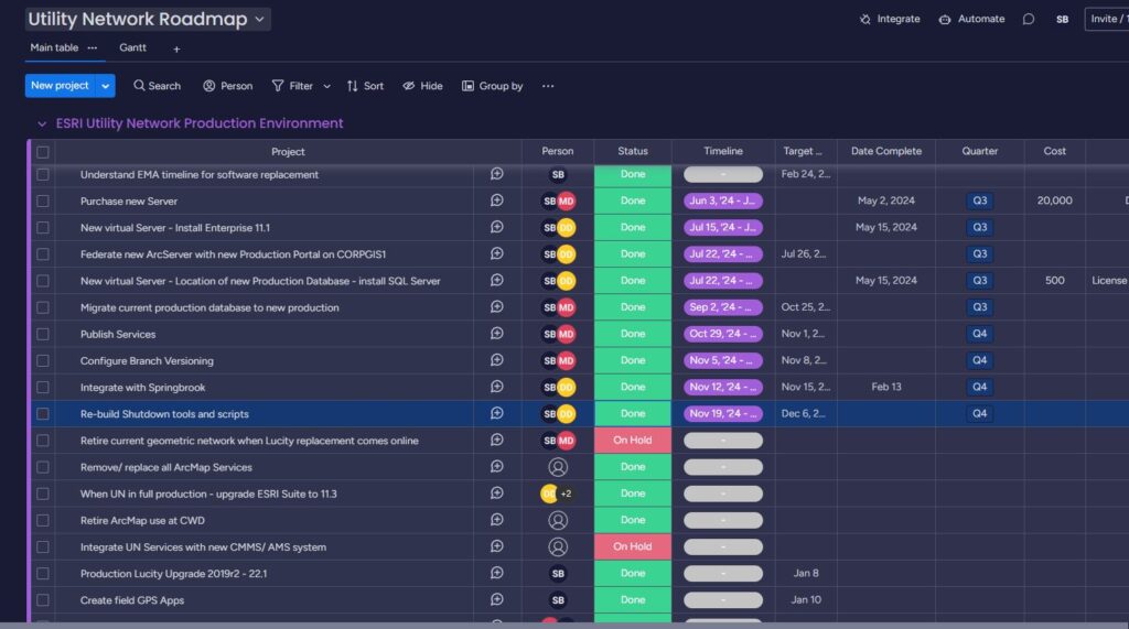
“At one point, the only way to move forward was to delete the old configuration out of our asset management system (Lucity),” Shawn said. “We could get it back if we needed to. But to move forward, we had to hit ‘delete’ and watch 10 years of integration disappear for this new way of life. So, that was a pretty big day.” This effort has led to a review of assets in the system and has cleaned up several discrepancies, leading to better managed assets.
Timing wise, the team made the utility network live early in 2025. That’s when the district had the least amount of construction and infrastructure development. As projects completed and went through final approvals, the new network reflected the assets. Trying to complete this work in the summertime, when the highest volume of new assets typically come online, would have been a real challenge.
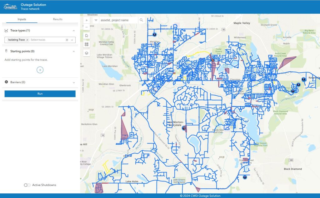
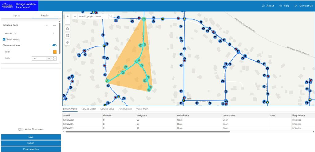
Enhancing the Water Outage Solution, a Key to Migration
The district employs a part-time software developer, Dan Dulan, to solve some of the most challenging data problems in-house. Previously, the district had relied on the Water Outage solution built by Esri for the geometric network to communicate water outages across the organization. The district had made enhancements to this tool to email notices of outages and create lists for customer notifications. This tool has seen wide adoption across the organization, and abandoning the tool was not an option.
Rebuilding the tool was essential to the Utility Network migration and had to be created from scratch using the ArcGIS API for JavaScript. Over a year was spent developing the solution. The tool now uses the tracing capabilities of Utility Network, bringing enhanced efficiency to communicate to internal and external stakeholders regarding water outages. The district would not have been able to go live with ArcGIS Utility Network without this critical application.
Validating the GPS Workflow to Allow Field Crews to Keep Moving
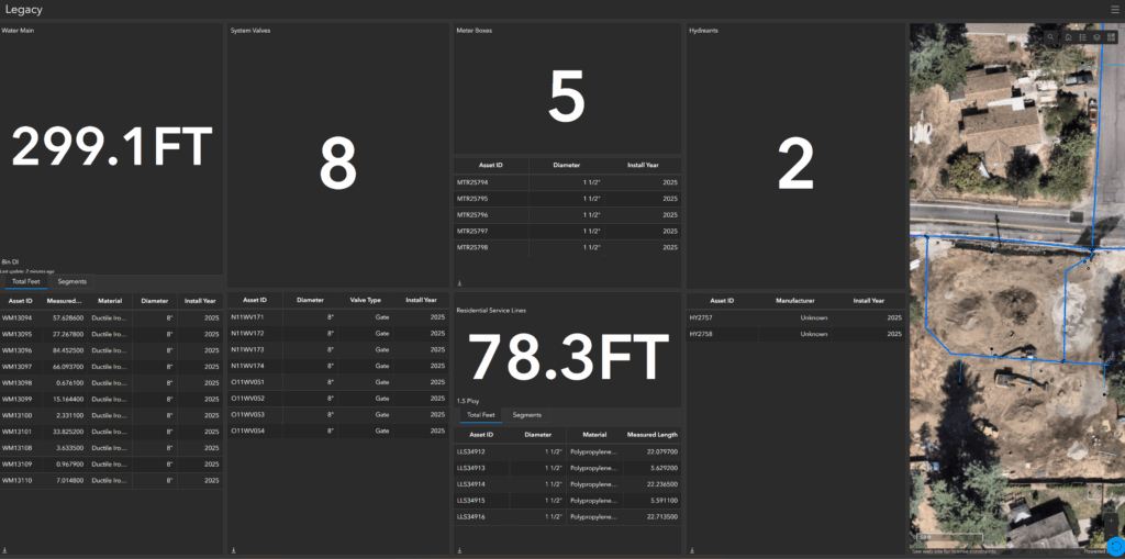
The district uses GPS extensively, managing projects with the satellite-based mapping technology in the field. As Mike Velasco says, “It’s the birth of an asset. It’s how we keep our asset registry current.” Inspectors and operations staff members collect GPS data on new pipes and other assets as they are installed in the ground. As the data is collected, GIS staff input the new assets into the asset management system and build dashboards to assist the organization with the financial closeout process. Utilizing GPS in this manner has taken many years to develop but has had many positive effects on interdepartmental communication and collaboration.
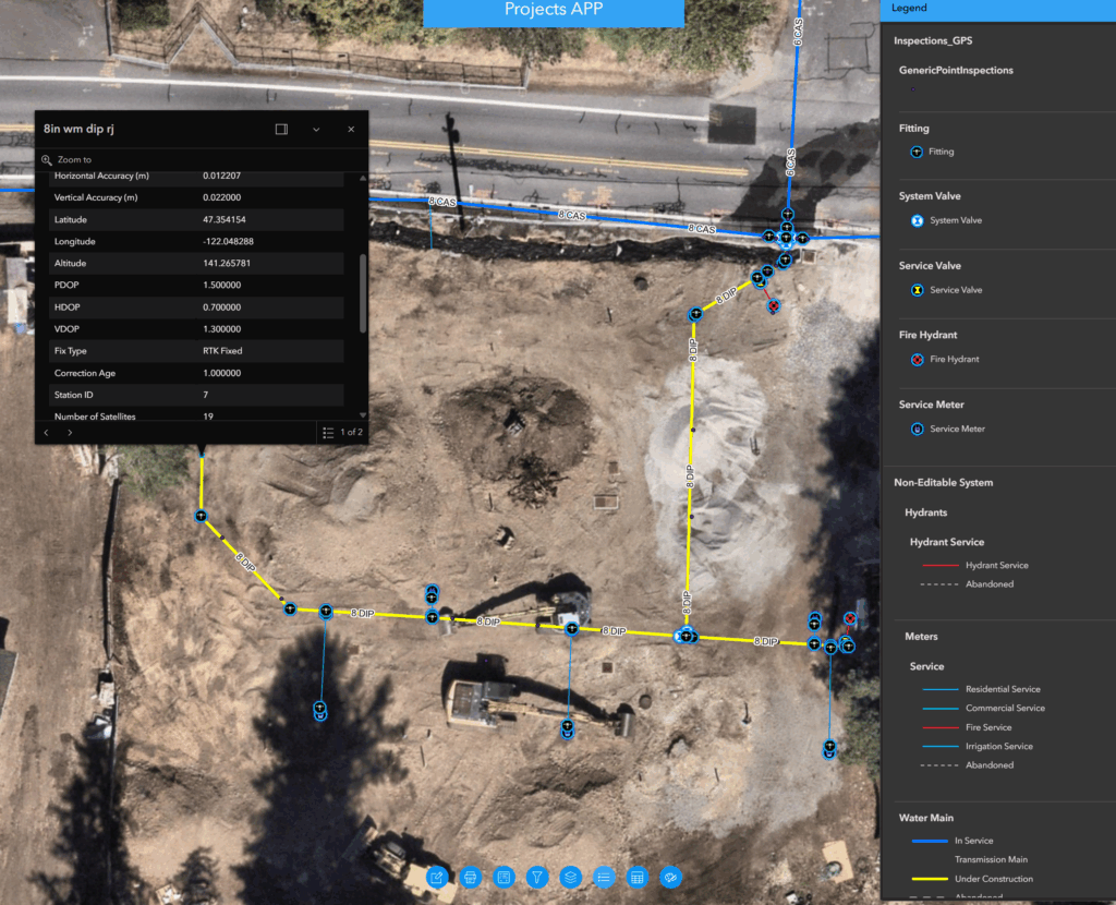
As the district embraced Utility Network and branch versioning, the GPS workflows needed to be updated and involved several rounds of testing through the DEV environment. The workflow the district adopted into production necessitated making copies of their Water Device layer and Water Junction layer schema to a new dataset in order to create separation between field data and production data. This option gave Covington Water the best path forward instead of using a hosted feature layer or collecting points directly into the Utility Network datasets.
The district updated all field devices to the new production workflows in winter 2024 to avoid the busy construction season. This allowed field staff time to test and provide feedback on the process without being overwhelmed. The critical workflow transition could not have been achieved as efficiently without the DEV testing period.
Learning the Latest Esri Tools to Troubleshoot Issues In-House
In the past, Covington Water hired technology consultants with mixed results. Many of the teams built great solutions, but the technical expertise left when the contract was complete. With the Utility Network development, district employees saw an opportunity for everyone in the organization to work more efficiently and learn.
“We made a concerted effort to keep a lot of the work and knowledge in-house,” said Steve Lee, Covington Water District engineering manager. “But we knew we couldn’t get there without expert help from HDR. Joel Griffin was key—he’s a very good teacher. He’s part of our team.”
The district was willing to learn the solution alongside HDR staff. “We didn’t have that experience of developing a turnkey solution and training the client when we gave the data back,” Joel said. “HDR worked as the adviser, and the collaboration piece was the crucial part.”
“I’ll also give the district credit that they never panicked when things were tough,” Joel added.
That level of trust has now permeated the organization. Covington Water’s general manager, operations, customer service, and board of directors have a clearer picture of their assets.
“We have full support from our leaders,” Mike Velasco said. “They’ve asked, ‘What’s next?’”
Benefits of Implementing ArcGIS Utility Network
- Better Q/A control for asset management
- Autogenerating AssetID’s using attribute rules
- ArcGIS Pro editing has been streamlined by having multiple maps open in one project space
- Standardized data model, easier to share with others
- Data management improvement, eliminating the need for replicas
- Configured traces enable non-GIS users to conduct network analysis
- Eliminated the need for database maintenance as compared to traditional versioning
- Driver in upgrading Covington Water’s asset management platform (Lucity)
- Driver in GIS architecture footprint improvements
- Eliminated need for PDF map books by converting to offline Field Maps for emergency management
- Set district up for future capabilities
Building Momentum with GIS
With the utility network as a foundational centerpiece of the data ecosystem, Covington Water plans to explore a new hydraulic modeling software that will integrate better with the GIS environment.
“GIS is our central hub, and there are offshoots everywhere,” Steve said. “That’s how we are structuring our data.”
Further enhancements are anticipated using ArcGIS Utility Network as the foundation, including flushing program enhancements, supervisory control and data acquisition (SCADA) integration, artificial intelligence exploration, and interlocal agreements to assist other agencies.

Stay Connected with Esri’s Water Team
ArcGIS is an extensive information system that enables modernization of workflows with easy-to-use applications. Strengthen your organization with GIS-based solutions that will increase efficiency and provide insight for decision-makers. Visit the Esri Water Utilities web site for more information.
Join the Water Utilities Community
Follow #EsriWater on social media: X | LinkedIn
Download the Building a Modern Network Information Management System eBook
Subscribe to the Water Industry newsletter “Esri News for Water Utilities and Water Resources“