For nearly three decades, ECC Technologies has helped communities bring fiber where it did not previously exist. Founded in 1997, the firm provides technology consulting, design engineering, construction management, and commercialization services focused primarily on fiber optic networks in rural, unserved, and underserved areas, while also supporting open-access fiber deployments in suburban and urban environments. Today, ECC manages thousands of miles of fiber across multiple states and supports clients throughout the full lifecycle of their networks, from early planning and permitting through construction, operations, and ongoing maintenance.
As ECC’s project portfolio grew in scale and complexity, the company recognized that the tools and workflows that had served it well in the past were no longer sufficient. Paper-based processes, static design sets, and disconnected spreadsheets made it difficult to manage projects efficiently, maintain real-time visibility, and scale operations without adding staff. To address these challenges, ECC didn’t simply adopt new tools, they engineered their own integrated project‑management solution, the ECC Dashboard™, built on Esri ArcGIS Online and enhanced with custom tools / widgets, and workflow automation. This transformed GIS from a supporting function into the operational backbone of the organization.
“The ultimate goal is how do we get fiber where it isn’t,” said Cory Brown, partner and CTO of ECC, “and then how do we allow those clients or customers to be able to leverage that fiber asset once it’s actually on the pole or in the ground to deliver value and sustainable network systems.”
From Paper and PDFs to a Digital Foundation
Like many firms in the fiber industry, ECC historically relied on printed plan sets, marked-up drawings, email chains, and manual data transcription to manage projects. Designs were created, issued for bid, redlined in the field, and later reconciled back into CAD or diagramming tools. Each handoff introduced delays and opportunities for error. Information lived in multiple places, and teams often spent time tracking down the most current version of the truth.
ECC leadership saw an opportunity to move beyond GIS as a static mapping tool and instead use it as a living system of record. The goal was to consolidate design data, construction status, permitting, make-ready activity, field notes, and asset information into a single environment that could be accessed by designers, construction managers, field crews, and clients alike.
“We really wanted one source of truth,” said Brown. “What is the ultimate set of information that everybody can go and reference and get the same answer because it’s all the same data set?”
That vision began to take shape when ECC expanded its use of ArcGIS Online and began developing customizable dashboards and custom tools tailored to fiber network delivery. What began as a modernization effort evolved into a custom engineered solution with, a suite of interconnected dashboards, tools, and interfaces built by ECC’s development team using ArcGIS Online, Esri SDKs, and proprietary code.
Addressing Make-Ready and Construction Complexity
One of the most significant pain points ECC faced was managing make-ready work, often the longest and most unpredictable phase of fiber deployment. Coordinating pole applications, tracking utility responses, monitoring contractor progress, and identifying schedule risks required constant manual oversight. Without a centralized system, it was difficult to see bottlenecks early or provide timely updates to clients and funding partners.
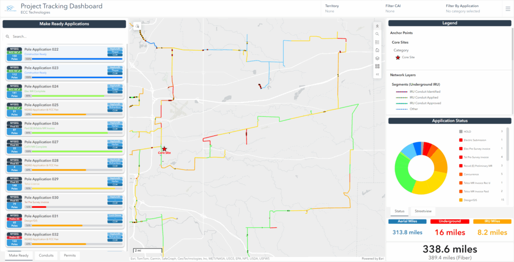
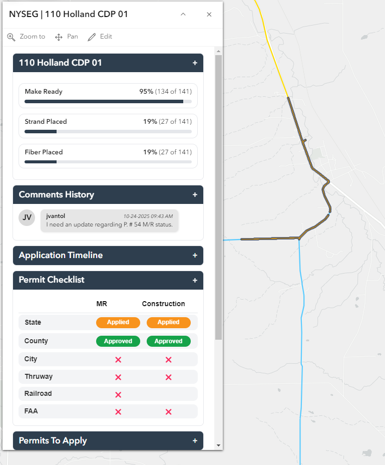
Using ArcGIS Online as a spatial engine, ECC developed the ECC Dashboard™, which integrates maps, status tracking, workflow automation, and custom widgets.
Fiber routes, pole applications, and construction segments are now visualized on an interactive map, color-coded by progress and linked to attribute data that shows completion percentages, dates, and dependencies. Lists, charts, and progress indicators allow users to quickly understand where a project stands and what requires attention.
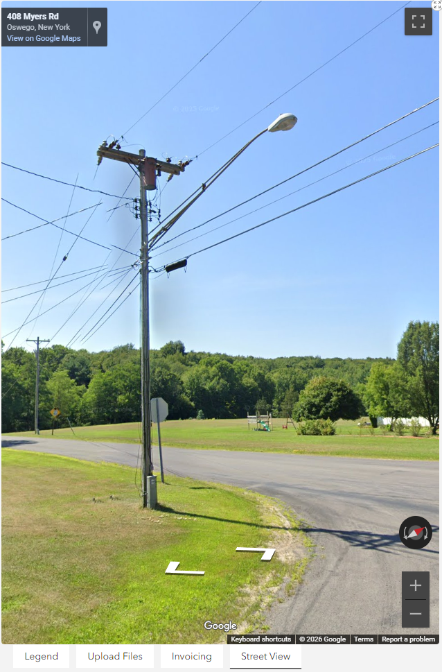
Because the data lives in ArcGIS Online, updates from the field sync in near real time. Field staff can enter comments, update statuses, and attach photos or documents directly from tablet-enabled devices. Office staff and project managers immediately see those updates reflected in dashboards, reducing phone calls, emails, and lag time.
This approach proved especially valuable for make-ready tracking. ECC can now monitor each application from submission through approval, identify steps that are taking longer than expected, and intervene before delays cascade into construction schedules.
“That make-ready portion is one of the longest tasks when you’re building these fiber networks, and these tools have simplified our lives in so many ways,” said Matt Corrette, ECC construction manager.
Turning GIS into an Operational Command Center
As ECC’s internal teams grew more comfortable with the dashboards, GIS became a shared language across departments. Accounting, engineering, construction management, and leadership all reference the same system, even if they do not consider themselves GIS users. Weekly internal meetings are anchored by dashboard views that provide a clear, current picture of project status.
To support this shift, ECC developed both internal and external dashboard views. Internal users can edit attributes, update dates, log comments, and manage workflows directly within the interface. External dashboards provide clients with real-time visibility into progress while limiting editing capabilities. This balance allows ECC to maintain data integrity while increasing transparency and trust.
To make the system accessible to GIS and non-GIS users alike, ECC built custom forms, widgets, and simplified interaction tools using ArcGIS SDKs and proprietary applications.
For example, ECC created simplified forms that allow users to update pole counts, change statuses, or upload files without interacting with traditional GIS attribute tables. Documents such as invoices, design files, and permits can be attached directly to features, ensuring that critical information stays connected to its geographic context.
“GIS is really at its core, and now we have a bunch of different departments communicating to each other through our Esri dashboards—whether they know they’re doing GIS or not,” said Ayush Joshi, ECC’s GIS developer.
Supporting Smarter Decisions and Cost Control
With comprehensive data in one place, ECC can evaluate design and construction decisions more effectively. When make-ready designs reveal costly pole replacements, teams can quickly assess alternatives, such as underground installation, and compare impacts on budget and schedule. Having spatial, financial, and status data integrated allows ECC to present clients with informed options early, rather than reacting to surprises later in the project lifecycle.
The platform has also improved break/fix response. By combining asset data with monitoring inputs, ECC can more precisely locate faults, dispatch contractors with clearer guidance, and streamline quality control and invoice approval. What once required multiple tools, and significant manual effort can now be initiated and tracked within a single system.
Scaling Without Expanding Headcount
Perhaps the most compelling outcome of ECC’s Esri adoption is its ability to manage more work without proportionally increasing staff. Today, the firm oversees multiple large-scale fiber projects simultaneously, along with numerous smaller efforts, using essentially the same team size. Dashboards, automation, and centralized data reduce rework, eliminate redundant communication, and prevent issues from slipping through the cracks.
“We would probably need two and a half times the workforce we have now to manage these projects if we didn’t have systems and tools in place like this,” said Corrette.
Reporting has also improved. ECC can generate executive summaries and detailed exports directly from the Dashboard™, supporting internal decision-making as well as external reporting to municipalities, utilities, and funding agencies. Leaders gain visibility into productivity, resource allocation, and project health, enabling faster course corrections and reinforcing accountability across teams.
What’s Next for ECC Technologies
ECC continues to view the ArcGIS environment as an evolving platform rather than a finished product that adapts to future needs of a project. Ongoing efforts include expanding automation, enhancing executive reporting, and further integrating financial and work order systems. As new challenges emerge in the field, ECC expects to continue iterating, building, and refining tools in conjunction with the Esri ecosystem.
“From where we started to where we’re at now, it’s been such an iterative process,” Brown said, “and it’s going to constantly evolve because we’re dealing with things in the real world.”
By placing GIS at the center of its operations, ECC Technologies has created a single source of truth that supports every phase of fiber network delivery. The result is greater efficiency, better collaboration, and a scalable foundation for connecting communities, today and in the years ahead.