East Valley Water District embraced the capabilities of Esri’s ArcGIS Utility Network to improve analysis, streamline workflows, and visualize the organization’s underground infrastructure.
Setting Goals for Modern Utility Data Management
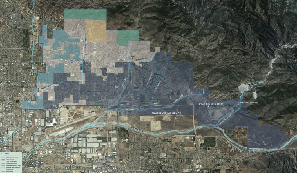
Based in Highland, California, East Valley Water District serves water and sewer services to over 100,000 residents across Highland and the city and county of San Bernardino. As a forward-thinking agency focused on leveraging modern technology, the district collaborated with Pro-West & Associates to upgrade from a geometric network to Utility Network. This would help the district manage its data—which had been migrated to ArcGIS Pro in preparation for the deprecation of ArcMap—in an up-to-date environment.
East Valley wanted to improve the way in which its data was organized, using the structure prescribed within ArcGIS Utility Network to improve accuracy, efficiently maintain the district’s most valuable information, and open doors to advanced capabilities.
East Valley was keen to take advantage of the analytical capabilities of ArcGIS Utility Network. The district saw an opportunity for more accurate water modeling and long-term infrastructure recommendations, as well as for budgeting and planning for maintenance such as pipeline replacements.
The district was also interested in integrating its geographic information system (GIS) data with more systems across the organization—such as utility billing and work order management—to eliminate redundant tasks. East Valley also wanted to replace manual processes for incorporating GIS data into other systems.
A Data-First Foundation
With a very small team with just one data editor, East Valley needed support to establish a foundation for managing data in Utility Network, eliminate redundant data, and clear a backlog of updates.
East Valley began its implementation with a data-readiness assessment. This laid the groundwork for the data cleaning and updates that followed. The readiness assessment also set the stage for developing the final schema. Esri’s water distribution and sanitary sewer industry data models were adapted to fit the needs of the district. Stakeholders from multiple departments were engaged in the development of the final schema. Pro-West worked with East Valley to identify authoritative datasets and eliminate data that was no longer needed, creating a clean slate in its utility network. Data representing previously private sections of the distribution network resided in separate feature classes; this data was combined, eliminating duplicate datasets and more accurately representing network connectivity. Partially populated fields from one-time integrations were dropped during migration, resulting in leaner, more meaningful attribute data.
Data cleanup and editing was performed concurrently with utility network configuration, forging an efficient start to East Valley’s journey to more modern utility data management. As the data model was adapted to meet the district’s needs, data-editing and -cleaning activities provided concrete examples for discussion among stakeholders to help clarify how elements of the data model could be configured to support analytics and data integrity.
“Implementing Utility Network gave us an opportunity to organize our data in a way that would work best for us. We removed data that we didn’t need and figured out what we needed to keep. We were determined to fully leverage the way in which data is organized in ArcGIS Utility Network to achieve our goals.”— Sarah Paredes, Information Technology Analyst at East Valley Water District
Implementing ArcGIS Utility Network
After the data was prepared and the final data model was designed, the data was officially migrated into the utility network model, and connectivity rules and other network elements were configured.
After a period of testing and initial review, a few adjustments and additions were made to asset types and connectivity rules, and the data was loaded onto the district’s enterprise database. Pro-West supported the district with training targeted for engineering staff, who will integrate utility network data into their work, and IT staff, who are leading editing workflows. Operational activities and organizational resources were transitioned to ArcGIS Utility Network through the development of viewers for field staff; integrations with inspections, asset management, and work order management systems; and new editing workflows that include QC performed by engineering.
Improving Water Analysis
From forecasting maintenance activities to managing budgets, data analysis is critical to East Valley’s operations. ArcGIS Utility Network rules that govern connectivity ensure data integrity, so the district can produce more accurate water and wastewater strategic plans with enhanced long-term planning and, therefore, budgeting.
The tracing capabilities offered by ArcGIS Utility Network supports a consistent feedback loop that helps staff understand their network and, in turn, improve data quality by leveraging institutional subject matter expertise. Tracing reveals details such as a valve that is designated as normally closed, as opposed to operational. For example, tracing allows users in the field to identify which valves to shut off during emergencies—when tracing reveals that a valve isn’t isolating water where it should, errors in the system are found and corrected.
Tracing also provides valuable hydraulic analysis with alternative flow models for subject matter experts to evaluate for feasibility/real-life errors. When the model is run and the results are interpreted, the knowledge gained is used to guide capital project and budget planning in accordance with the district’s strategic plan, which includes efforts dedicated to system maintenance and modernization.
Tracing reveals errors in connectivity and valve status that subject matter experts can then correct. Working with consultants on activities such as water modeling and pipeline replacements delivers greater value, since East Valley is able to supply higher-quality data for the consultants’ use.
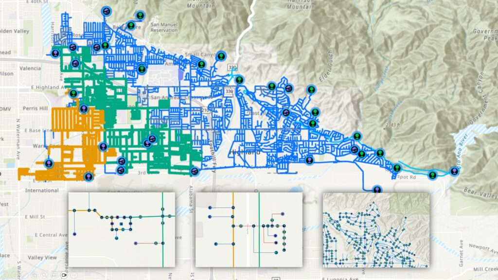
For the first time, the district has an accurate representation of its underground assets, providing a valuable tool for analyzing and planning infrastructure improvements.
Connecting Systems
East Valley’s systems for utility billing, work order management, and finance rely heavily on GIS data, but incorporating it used to involve manual data entry and inefficient processes. ArcGIS Utility Network has empowered East Valley to streamline its system integrations with seamless workflows and automatic data updates that minimize opportunities for error across systems.
Meter readings are now automatically updated in East Valley’s Tyler Technologies utility billing software instead of being manually imported. The structure in which Utility Network organizes data allows better alignment of the two systems, minimizing meter data discrepancies. The integration between GIS and the utility billing system has had a positive impact on the implementation of automated meter reading across East Valley’s customer accounts, making data synchronization possible between the old and new meter types.
Utility Network also enables East Valley to improve integration between its GIS data and finance system (for budget management) and with its work order management system, which ties to both utility billing and GIS and has benefited from connection with maps, underground infrastructure, and meter information.
- ArcGIS Utility Network is integrated with the district’s financial system to capture billing and consumption data. This data is transferred through an API to the Tyler Technologies financial system, where it is processed and prepared for customer access through the customer portal.
- ArcGIS is connected to the work order management system to record infrastructure maintenance activities, including working on breaks, leaks, and repairs. These activities support the annual water audit. In addition, inventory items associated with each work order are linked to the Tyler Technologies financial system, allowing it to automatically calculate and complete the general ledger entries for both work orders and inventory usage.
Building on ArcGIS Utility Network with GIS Apps
Utility Network served as a gateway for East Valley to access and deploy GIS solutions to further improve operations. Data managed in this modern environment is consumed by interactive maps and apps based on ArcGIS technology that enhance customer service, ease information sharing, and streamline workflows:
- Water Loss Notifications—A solution for East Valley’s public affairs department to efficiently notify customers about water loss impacting them
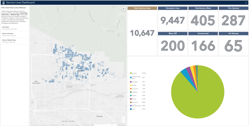
- Operations Dashboard—Provides administrative users with an at-a-glance view of valuable data such as water asset breakdown/information totals
“Having migrated to Utility Network, we recognized there were more possibilities now available to us, and we want to make sure we were taking full advantage. We deployed solutions that solve problems, such as our overloaded data catalog and issues [in] our master maps including inaccuracies, information that wasn’t necessary for operations, and slow performance. We are now working more efficiently, with maps that are faster to load, are cleaner and more modern; and data that is free of errors and bugs and is easier to understand, navigate, and use within our ArcGIS Pro and web environments. We’ve also been able to add detailed plant facility data for the first time. When the system integration links were updated with the utility network data, we saw the same result: faster, cleaner data with an updated and reliable dataset.”—Sarah Paredes, Information Technology Analyst at East Valley Water District
Sharing Lessons Learned
For another organization considering migration to Utility Network, Paredes offers the benefits of her experience: “Become as familiar as possible with your current data. Knowing what you have will help you identify how you want to use it moving forward. I’ve been with East Valley for a long time and understanding the sources of the data and how (or if!) we were using it was invaluable to our [Utility Network] implementation. This is your opportunity to create a new, clean GIS dataset, so take advantage of the process to reorganize; clean up; implement new standards; and start fresh with authoritative, valuable utility data.”
What’s Next for East Valley Water District
East Valley has plans to keep growing and enhancing its system:
Performing long-term data maintenance—Maintaining accurate data depends on a robust plan for ongoing maintenance. East Valley partners with Pro-West & Associates to make sure updates are made on a defined schedule, preventing another backlog from being created and upholding users’ confidence in the district’s data.
Launching a public information portal—The portal will provide auser-friendly way to find information for contractors and individuals who want to build in the area.
Adding the district’s newly opened sewer treatment plant to its Utility Network deployment—This will extend the advantages of data management, system integration, and efficiency to the district’s entire operations.
Updating symbology—In-keeping with East Valley’s focus on modern tools and workflows, updating Esri’s ArcGIS Utility Network symbology is part of the plan. The updated symbology establishes trust, signaling that the underlying data is up to date.
Implementing a map series—East Valley plans to implement a map series that reflects the updates made to data in ArcGIS Utility Network. A map series offers an efficient way to publish up-to-date information on an ongoing basis, replacing outdated map books.
“We are excited to keep leveraging GIS tools to further improve operations at East Valley. Implementing ArcGIS Utility Network was a crucial first step in modernizing how we manage and use our data, and it’s opened a lot of doors for us. We look forward to bringing even more of our vision to life.”—Sarah Paredes, Information Technology Analyst at East Valley Water District

Stay Connected with Esri’s Water Team
ArcGIS is an extensive information system that enables modernization of workflows with easy-to-use applications. Strengthen your organization with geospatial solutions that will increase efficiency and provide insight for decision-makers. Visit the Esri Water Utilities web site for more information.
Join the Water Utilities Community
Follow #EsriWater on social media: X | LinkedIn
Download the Building a Modern Network Information Management System eBook
Subscribe to the Water Industry newsletter “Esri News for Water Utilities and Water Resources“