Situation
Major infrastructure programs depend on accurate, timely information to keep construction activities on schedule, maintain regulatory compliance, and support informed decision-making. Yet project data is often generated by multiple teams using disconnected systems for surveying, drone mapping, environmental monitoring, construction documentation, and reporting. As projects become larger and more complex, owners and contractors need a more effective way to connect this information and create a shared understanding of site conditions.
The U.S. Army Corps of Engineers (USACE) New Orleans District faced this challenge on several high-profile infrastructure initiatives, including the Confined Disposal Facility dredge material management project and the Comite River Diversion flood risk reduction project in Louisiana. Both programs required accurate surveying, construction monitoring, progress documentation, and ongoing visibility into evolving site conditions.
Challenge
Project stakeholders were managing large volumes of information spread across survey files, engineering plans, compliance records, earthwork measurements, field observations, weather data, and recurring drone surveys. This fragmented approach made it difficult to maintain a current operational picture of project status and support timely project decisions.
On the Comite River Diversion project alone, hundreds of acres of active construction needed to be monitored over multiple years. Teams required consistent access to current site information while maintaining accurate reporting and documentation throughout the construction lifecycle. Similarly, construction of the new Confined Disposal Facility along the Gulf Intracoastal Waterway in Iberville Parish, Louisiana demanded recurring volume calculations, progress monitoring, and coordination among project stakeholders.
Solution
USACE partnered with ES2, an Esri Gold Partner specializing in geospatial services, surveying, engineering, and environmental consulting, to develop a location-based approach for managing construction information across these projects. Leveraging the ArcGIS platform, ES2 connected drone mapping, field data collection, surveying activities, engineering information, and project reporting into a unified operational environment.
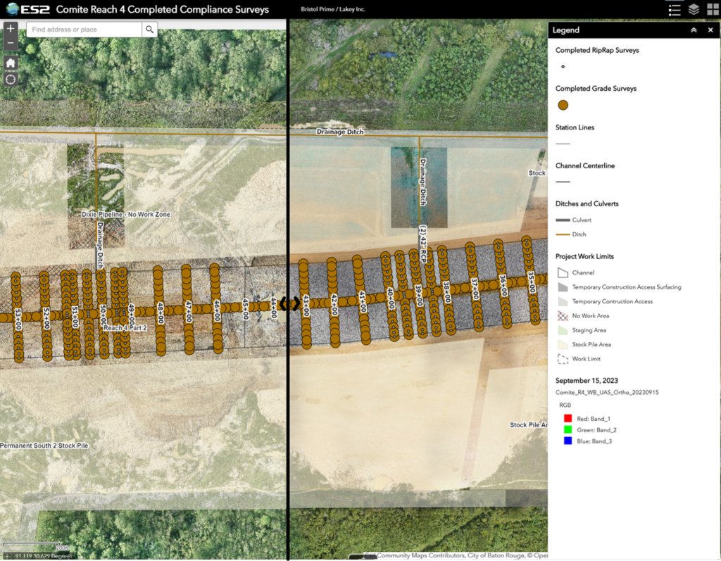
For the Comite River Diversion project, ES2 served as the surveying and mapping subcontractor, providing UAS mapping, survey control, boundary surveys, and right-of-way stakeout services across approximately 400 acres of active construction. The firm integrated drone imagery, survey records, CAD plans, compliance documentation, and field observations in ArcGIS. ES2 also deployed ArcGIS Field Maps and ArcGIS Survey123 to support field verification, geotechnical observations, and project reporting activities.
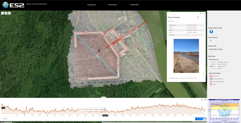
For the Confined Disposal Facility project, ES2 established project survey control, conducted pre-construction and existing-condition surveys, and supported construction layout activities. The team also implemented a drone-to-GIS workflow using ArcGIS Drone2Map and ArcGIS Online to process recurring UAS surveys and publish current project information in a shared geographic environment. This enabled project teams to track earthwork volumes, monitor construction progress, develop machine-control models, and incorporate real-time weather information from a centralized dashboard.
Results
By implementing ArcGIS-based workflows, ES2 helped USACE establish a single source of truth for project information across both programs. Rather than relying on disconnected files and manual reconciliation processes, project teams gained access to current, location-based information that could be shared across stakeholders.
On the Comite River Diversion project, ES2 completed more than 48 recurring UAS surveys, providing USACE with continuous visibility into changing site conditions throughout construction. Drone-based monitoring reduced the need for routine ground inspections while improving access to current project information. Over the course of the program, survey data, imagery, design information, and compliance records were maintained within ArcGIS, simplifying reporting requirements and creating a comprehensive digital record of project delivery.
On the Confined Disposal Facility project, recurring UAS-derived terrain models provided accurate monthly volume calculations, enabling more informed construction planning and material management decisions. Machine-control models generated from survey and drone data helped contractors work more precisely against design surfaces, reducing the potential for rework and improving overall project efficiency. Construction progress, compliance records, and weather conditions were consolidated within a single ArcGIS environment, improving coordination and project oversight.
Outcome
Through its work as an Esri Gold Partner, ES2 helped transform how major infrastructure projects were monitored, documented, and managed. By combining surveying expertise, drone technology, and ArcGIS capabilities, the firm enabled USACE project teams to improve visibility, strengthen coordination, support safer field operations, and make more informed decisions throughout construction. The result was a connected, location-based approach to infrastructure delivery that provided stakeholders with a trusted operational view of project progress and performance.
Stay Connected with Esri AEC
- Follow #EsriAEC on LinkedIn and X.
- Learn more about Esri Solutions for architecture, engineering, and construction.