Customer Spotlight Story
Pasadena Water and Power (PWP) operates a municipally owned electric utility that delivers reliable, affordable electricity to more than 65,000 customers in Pasadena, California. The Power Division manages a diverse energy portfolio, maintains distribution infrastructure, and ensures consistent service amid evolving energy demands and regulatory requirements.
Its operations include power procurement, system reliability planning, grid maintenance, and customer service, and it supports the transition to cleaner energy sources.
Rising infrastructure demands, operational complexity, and increasing community expectations have driven PWP to adopt a more integrated, modern approach. As a publicly owned utility, it remains focused on accountability, sustainability, and efficiency, demonstrating how local utilities balance reliability, cost control, and environmental goals.
GIS VISION
PWP’s use of geographic information systems (GIS) has evolved from early enterprise planning into a fully integrated digital platform, replacing manual workflows with a comprehensive framework for engineering, planning, and operations. This progression set the stage for more advanced applications, highlighted in recent work within the Water Division. Read the recent story.
Building on these advancements, the Power Division sought to replicate similar capabilities. The Water team’s GIS Express-supported applications, including main break reporting, water quality monitoring, UDF planning, and real-time advisory communication during the Eaton Fire, demonstrated the operational value of modern GIS tools.
During the Eaton Fire, these solutions played a critical role in emergency response and public communication, enabling residents to quickly identify affected service areas and underscoring GIS’s broader potential across utility operations.
CHALLENGE
After seeing the success of GIS solutions in the Water Division, electric staff engaged the PWP GIS team to identify similar or new innovations for power operations. The current Power Division did not have advanced capabilities comparable to those available in the Water Division.. The key challenge was how to adapt and apply those proven water solutions to power operations. For example, the Power Division did not have the same level of advanced analytics found in the Water Main Break application and dashboard, particularly for monitoring and responding to power outages. In addition, while ArcGIS Survey123 supported electric asset inspections, the absence of auto-population for key field data limited data quality and constrained its use for advanced analytics.
SOLUTION
Leveraging the Water Division’s GIS approach as a model, PWP advanced the development of dedicated GIS solutions for Power operations. This effort led to the establishment of an electric-focused initiative, Power GIS Vision. Built on modern ArcGIS tools, including ArcGIS Hub, ArcGIS Experience Builder, ArcGIS Dashboards, StoryMaps, and advanced web frameworks, Power GIS Vision extends the Water Division’s applications through several targeted solutions:
The Power GIS Hub serves as both a public-facing and internal gateway to Power GIS Vision. It provides an interactive platform for the public, internal teams, and cross-organizational partners to explore active projects, proposed plans, infrastructure data, and historical records related to Pasadena Power.
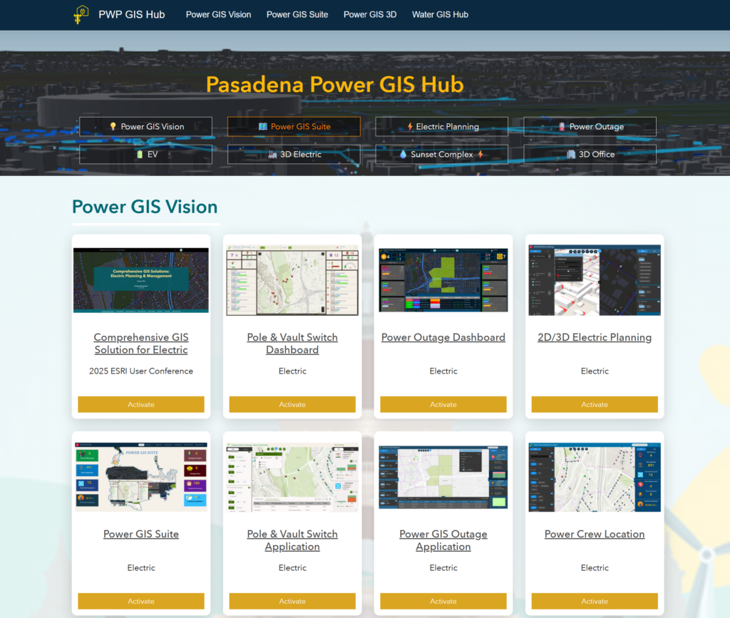
ArcGIS Hub provides a public-facing and internal gateway to Power GIS Vision.
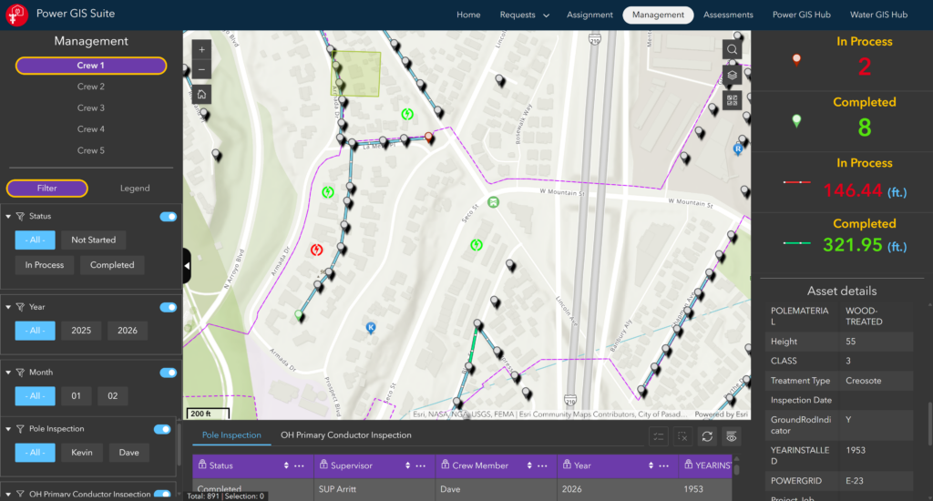
The Power GIS Suite, built with ArcGIS Experience Builder, ArcGIS Dashboards, ArcGIS Survey123, StoryMaps, and third-party open data sources, delivers a fully integrated operational and workflow environment. This continues the momentum set by the Power GIS Hub, deepening operational connectivity.
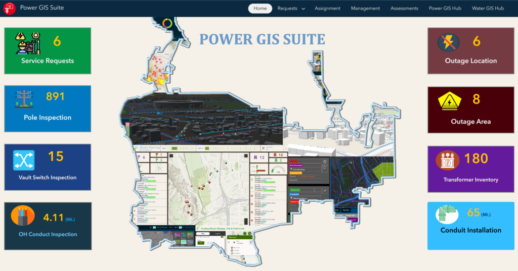
Power GIS Suite provides a fully connected, dedicated operational and workflow system.
To address specific operational needs, modular, lightweight Power GIS solutions were developed rather than creating a single large system. This approach improves usability and secures seamless enterprise integration, building on the structure established by the overall Power GIS Suite.
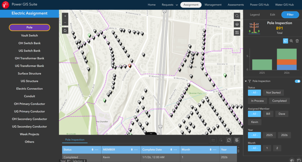
Power GIS Modules support specific applications.
Power GIS solutions include:
- Electric Planning and Inspection Management – The first major focus area was inspections, including poles, vault switches, and transformers.
- Power Outage Management and Community Support – The Power Outage application enables staff to map outage locations and impacted areas. It created a scheduled planned outage using batch tools. The application automatically calculates affected customer counts. Finally, it exports customer lists for coordinated outreach.
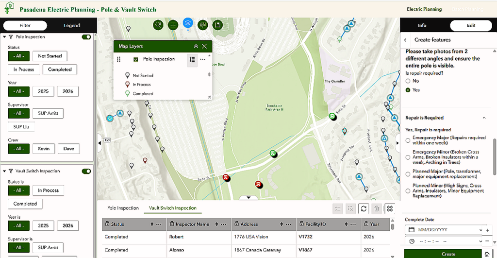
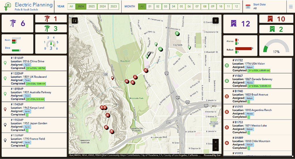
Electric Planning Solution
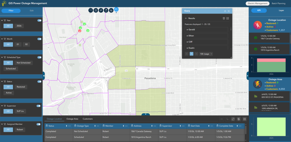
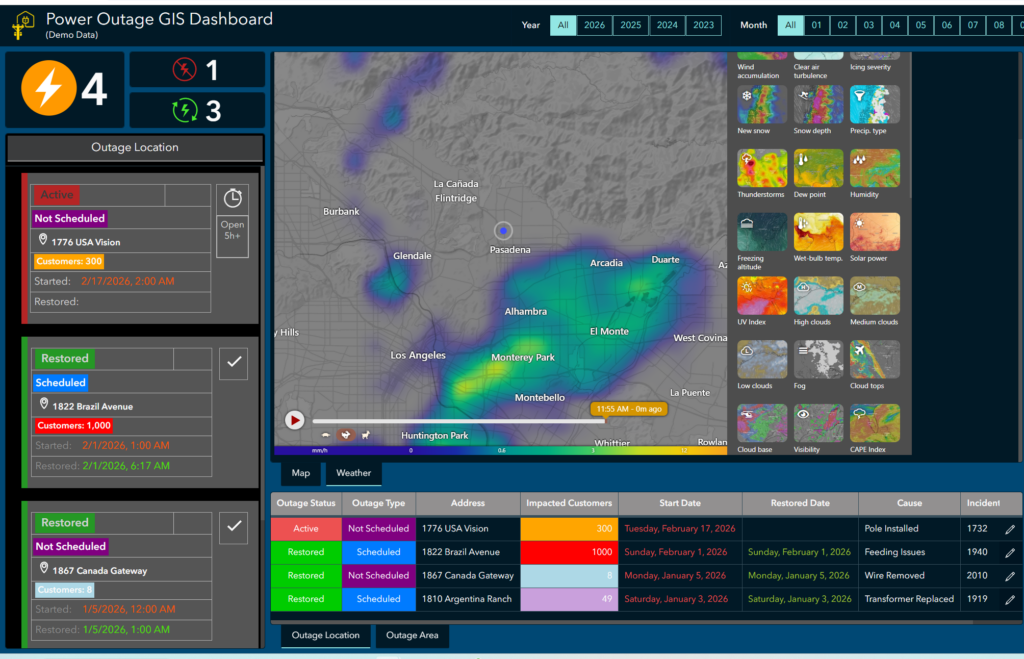
The Power Outage GIS Solution was a next-generation application, evolved from the Main Break Dashboard.
Crew Location and Scheduling – The platform also supports crew location monitoring, providing supervisors with real-time visibility into field crew positions.This capability improves coordination during outages and field operations by helping dispatchers and supervisors understand crew locations and the speed at which crews can respond to incidents.
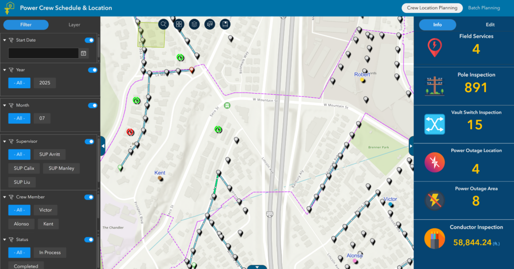
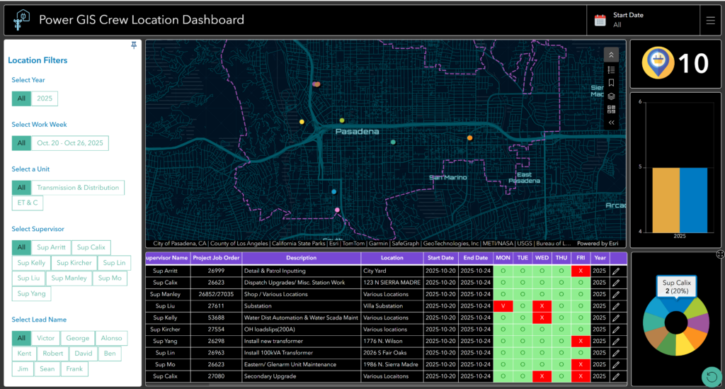
Crew Location GIS Solution
RESULTS
Power GIS Vision has evolved into a comprehensive GIS environment powered by modern ArcGIS technologies. By unifying these tools, engineers, planners, supervisors, and field crews can review and update projects, track inspections, monitor outages, manage assignments, analyze asset performance, and coordinate community response within a single GIS platform.
NEXT STEPS
Looking ahead, this GIS framework provides a scalable foundation for integrating additional city infrastructure systems and supporting long-term planning in Pasadena. PWP is exploring the use of 3D GIS to manage complex infrastructure, with the Vision application prototyping strategies to better visualize vertical and underground assets.
Three-dimensional visualization allows planners and engineers to understand infrastructure relationships within a spatial context, supporting long-term system planning and decision-making.
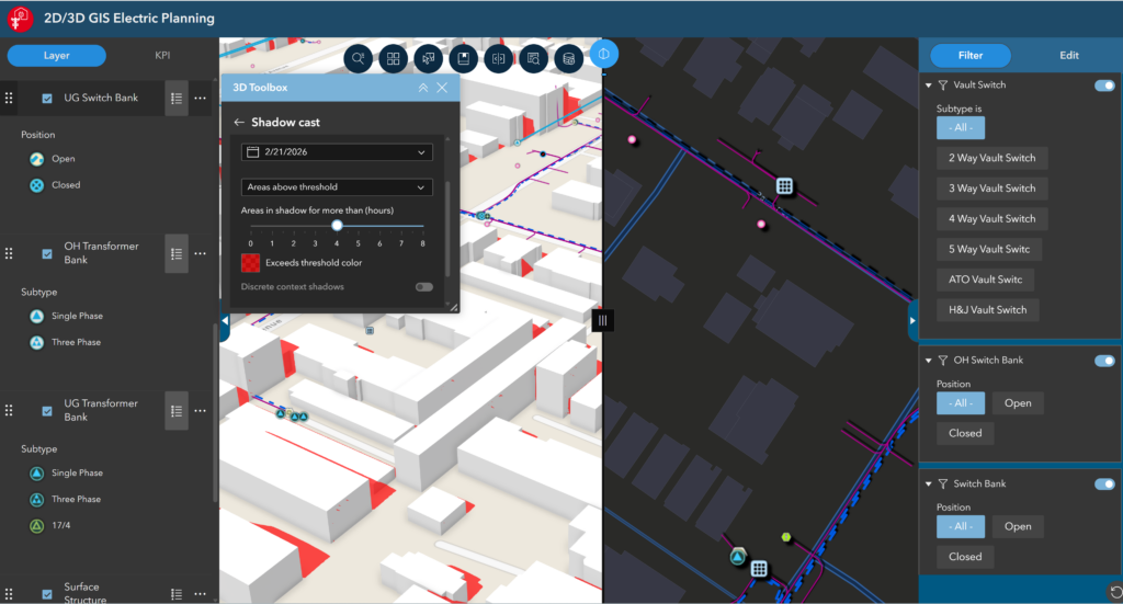
Three-dimensional visualization provides a powerful way to represent vertical infrastructure assets.
A POWER PLATFORM FOR THE FUTURE
Power GIS Vision marks Pasadena Power’s transition from traditional map-based GIS to a modern enterprise platform that supports planning, operations, and decision-making.
By integrating real-time operational data, mobile workflows, analytics dashboards, and emerging 3D capabilities, GIS now plays a strategic role in improving operational efficiency, infrastructure resilience, and public communication.
The scalable GIS framework positions Pasadena to unify infrastructure management and advance long-term resiliency.
SUMMARY
Challenge: Power operations lacked advanced analytics, automation, and coordination available in water applications, limiting system visibility and efficiency.
Solution: Created Power GIS Vision, an integrated, real-time platform with dashboards, mobile tools, and modular applications to enhance planning and operations.
Results: Delivered a cohesive environment that improves coordination, streamlines workflows, and enhances decision-making across teams.
Next Steps: Broaden the platform’s integration with infrastructure systems and expand 3D visualization to improve long-term planning.
“GIS Vision for Power is a pathway that enables GIS to transform the electric industry, turning data into real-time intelligence that enhances safety, efficiency, and community resilience”. – Owen Mo, PWP GIS Team.