Written by Justin Kirtz, GISP, GIS Manager at Greenville Water
Greenville Water serves more than 750,000 residents across 542 square miles in Greenville, Anderson, Laurens, and Pickens Counties in Upstate South Carolina. As South Carolina’s largest drinking water utility, Greenville Water maintains more than 3,200 miles of water mains and approximately $4 billion in water infrastructure. Every day, our teams rely on accurate data and efficient workflows to maintain system reliability while delivering on our mission of providing quality water for a sustainable future.
Responding to water main breaks and leaks is one of the most critical functions of any water utility. Quickly identifying affected customers, isolating the impacted area, and restoring service helps reduce water loss, improve system resilience, and minimize service disruptions. Just as important is keeping customers informed when planned or emergency repairs will interrupt their water service.
For years, Greenville Water relied on an automated interactive voice response (IVR) system to notify customers of planned outages. These notifications provide essential information, including when service may be interrupted, why the work is being performed, the expected duration of the outage, and when service is expected to be restored. Timely communication allows customers to prepare and helps reduce uncertainty during maintenance and emergency repairs.
Creating those notifications, however, was a labor-intensive process. Staff moved between multiple systems and manually performed GIS tasks to identify affected customers before generating a single IVR notification. Depending on the size and complexity of the outage, creating one notification campaign could take 15 minutes or more. The workflow was not only time-consuming but also increased the potential for human error, particularly during larger or more complex repair events.
Following Greenville Water’s migration to Esri’s ArcGIS Utility Network with Esri partner DCSE, the GIS Department reimagined this process by integrating its existing custom web GIS IVR notification application with ArcGIS Utility Network’s tracing capabilities. The result is a custom web application that automatically identifies affected customers using ArcGIS Utility Network traces and seamlessly generates IVR notifications through Twilio, a cloud communications platform. What was once a manual, multistep workflow can now be completed in just a few clicks, improving efficiency, reducing errors, and enabling staff to notify customers faster when every minute matters.
Project Background
Before implementing ArcGIS Utility Network, Greenville Water’s field operations and engineering teams relied on three separate systems to create customer outage notifications: a web GIS application, Microsoft Excel, and a third-party IVR platform. Moving between these disconnected applications made the process time-consuming, especially when responding to emergency repairs.
The workflow began in a web GIS application, where staff manually selected the customer accounts they believed would be affected by the planned outage (Figure 1). While this approach worked well for straightforward repairs, accurately identifying affected customers became increasingly difficult as outages grew in both size and complexity. Selecting too many customers resulted in unnecessary notifications, while missing affected customers meant some customers could receive no advance notice of a planned outage. Once the selection was complete, the customer list was exported to Microsoft Excel.
The exported spreadsheet then required extensive manual formatting before it could be imported into the IVR platform. Staff removed unnecessary fields, added required columns, corrected data types, deleted records without phone numbers, and reformatted telephone numbers to meet the platform’s import requirements. These manual steps added unnecessary complexity and were particularly cumbersome when performed on a mobile device during after-hours emergency repairs.
Once the spreadsheet was prepared, staff switched to the IVR platform to create the notification campaign. They manually uploaded the customer list, configured the campaign, and navigated through numerous screens and settings, many of which were unnecessary for Greenville Water’s workflow. The process required repetitive data handling, increased the opportunity for human error, and often delayed customer notifications during time-sensitive repair events.
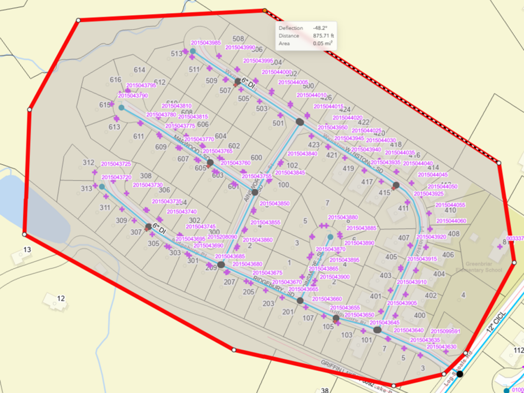
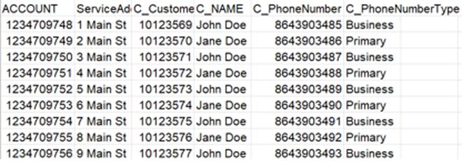
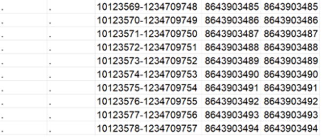
Figure 1: Before implementing Esri’s ArcGIS Utility Network, staff manually selected affected customers in a web GIS application and reformatted the exported data in Microsoft Excel before creating an IVR notification campaign. The process was time-consuming and became increasingly inaccurate for larger or more complex repairs.
Custom Utility Network Solution
Greenville Water’s web GIS application is a custom solution built with the ArcGIS Maps SDK for JavaScript. The SDK provides the flexibility to integrate third-party libraries, allowing the development of workflows that extend beyond the capabilities of out-of-the-box applications. For this project, Greenville Water integrated the cloud communications platform Twilio, using its Voice and SMS APIs to create and deliver customer notifications directly from the web GIS application through a simplified user interface.
Before migrating to ArcGIS Utility Network, staff identified potentially affected customers by drawing a selection polygon around the anticipated outage area. The selected customer account numbers were then used to query the customer information system (CIS) for associated phone numbers. While this workflow was adequate for straightforward repairs, it relied heavily on operator judgment during larger or more complex outages. Selecting too many customers resulted in unnecessary notifications, while selecting too few could leave affected customers without advance notice of a planned outage.
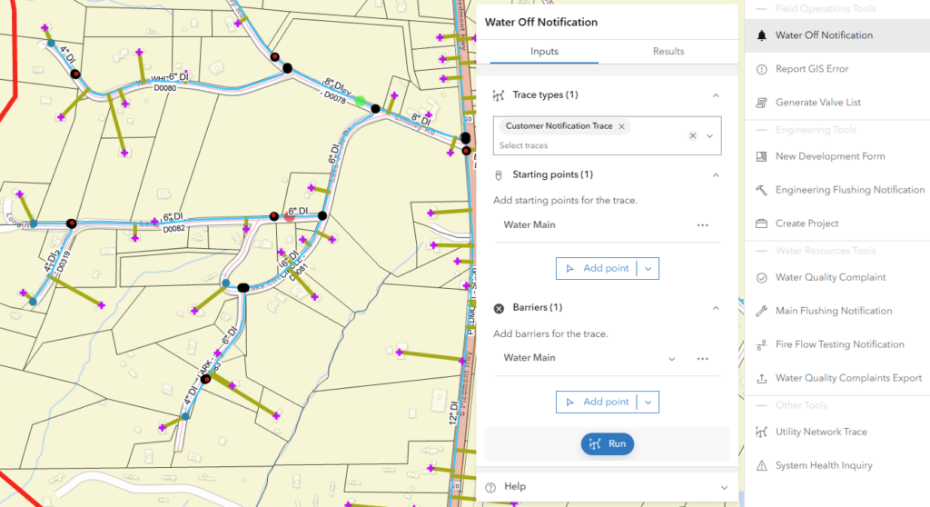
The migration to ArcGIS Utility Network provided an opportunity to replace this manual process with a network-driven workflow. The sketch component was replaced with the Utility Network Trace Analysis component (Figure 2), which automatically loads a named trace configuration called Customer Notification Trace. This customized isolation trace identifies the minimum set of valves required to isolate the selected water main and returns the connected customer accounts and associated phone numbers that will be affected by the outage.
By leveraging actual network connectivity instead of a manually drawn geographic selection, the Utility Network Trace produces a more accurate list of affected customers while eliminating the guesswork associated with the previous workflow. The result is a faster, more reliable notification process that improves operational efficiency and helps ensure customers receive timely and accurate outage notifications.
“[ArcGIS] Utility Network gave us the opportunity to rethink a process that had remained largely manual for years. By combining network tracing with automated customer notifications, we created an innovative solution that saves our team valuable time, reduces unnecessary effort, and lowers operational costs while improving service for our customers,” said Kenneth Frazier, chief technology officer at Greenville Water.
Water Off Workflow Overview
The Water Off tool is accessed directly from the web GIS application’s toolbar and launches the Utility Network Trace Analysis component. To execute a trace, the user provides two inputs: a trace type and at least one starting point. The trace type is automatically populated with the Customer Notification Trace named trace configuration, which is preconfigured to return the customer account and phone number for every customer affected by the outage.
To begin the workflow, the user selects ‘Add Point’ and places a starting point on the water main that will be isolated for repair work. The trace follows network connectivity until the selected main is isolated. If additional control is needed, users can place one or more barrier points to prevent the trace from continuing beyond a specified location. This flexibility allows staff to refine trace results when responding to complex operational scenarios.
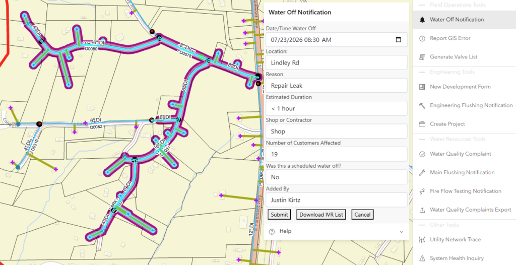
In a standard Utility Network Trace Analysis workflow, trace results are displayed for review and analysis. For the Water Off tool, however, that step has been streamlined. Instead of displaying the default results panel, the application automatically opens a custom Water Off form as soon as the trace completes. A separate Trace Analysis tool remains available elsewhere in the application for staff who need to perform detailed network analysis outside of the outage notification workflow.
Within the Water Off form, staff enter the information that will be communicated to customers, including the planned outage date and time, the reason for the interruption, and the estimated duration of the work. These values are stored as attributes in the Water Off GIS layer and are incorporated into the automated IVR notification.
The Customer Notification Trace also returns an aggregated geometry representing the complete traced network. This geometry is used to generate a buffer polygon, which becomes the spatial representation of the outage event in the Water Off GIS layer (Figure 3). The resulting feature provides a visual record of the affected area while supporting additional GIS workflows and customer communication. “The workflow is intuitive and easy to use. What used to require multiple programs and several manual steps can now be completed in one application with just a few clicks, making it much faster to create accurate customer notifications,” said Alla Solodiak, field operations planner.
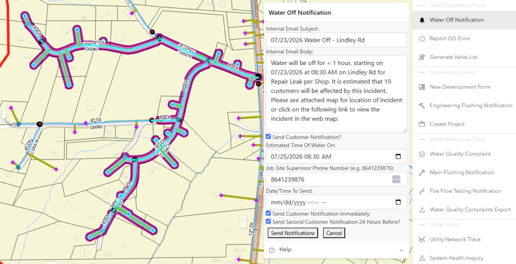
After completing the Water Off form, staff are taken to the Internal Email and IVR Notification form. The first section is dedicated to an automated internal email that is distributed to approximately 100 Greenville Water team members when the workflow is submitted (Figure 4). The email provides advance notice of the planned repair, includes a screenshot of the affected area, and contains a direct link to the Water Off feature in the web GIS application, giving internal staff quick access to the latest outage information.
A checkbox at the bottom of the form enables the Customer Notification section, allowing staff to create an IVR notification without leaving the web GIS application (Figure 4). To generate the notification, staff simply specify the anticipated service restoration time and when the IVR calls should be placed. Notifications can be sent immediately or scheduled for a future date and time.
The application also supports follow-up notifications without requiring staff to create a second campaign. When the Send Second Customer Notification option is selected, the system automatically schedules an additional IVR call to the same affected customers at noon on the day before the planned outage. This streamlined workflow reduces manual effort while ensuring customers receive timely reminders before scheduled repair work.
After clicking Send Notifications, staff are presented with a final preview of the IVR message to verify that all notification details are accurate before the campaign is submitted. Once confirmed, the application queues the notifications through the Twilio API and creates a new polygon feature in the Water Off GIS layer to document the outage event.
The Twilio API processes each affected customer returned by the Customer Notification Trace and automatically places the appropriate notification. During permitted calling hours (7:00 a.m. to 10:00 p.m.), customers receive both a voice call and a text message. Outside of those hours, only a text message is sent. Twilio’s built-in phone number validation also helps prevent notifications from being sent to invalid or incomplete phone numbers.
Additional workflow enhancements were incorporated into the application, including the ability to schedule a Water On notification after repairs are complete. Once water service has been restored, staff update the outage record by entering the restoration date and time in the Edit Water Off form. The application then queries the customer information system (CIS) and automatically sends a follow-up IVR notification to the same affected customers, confirming that water service has been restored. Because the original outage record is reused, staff do not need to recreate the notification campaign.

The application also helps identify customers who may not receive an automated notification. If the customer information system contains customer accounts without a valid phone number, the application automatically compiles a list of those accounts and sends an internal email to field operations, engineering, and customer service management. This allows staff to proactively contact affected customers using alternative communication methods, such as email, helping ensure that no customer is overlooked during planned or emergency outages.
Conclusion
The tracing capabilities of ArcGIS Utility Network extend far beyond asset management, providing opportunities to streamline critical business processes across a utility. At Greenville Water, replacing a manual, multi-application workflow with a solution supported by ArcGIS Utility Network transformed how customer outage notifications are created and delivered.
What once required several minutes and multiple software applications can now be completed in seconds from a single web GIS application. By leveraging actual network connectivity, ArcGIS Utility Network produces more accurate customer notifications while reducing manual effort, minimizing the potential for human error, and improving communication with customers during planned and emergency outages.
More importantly, this project demonstrates how ArcGIS Utility Network can serve as the foundation for operational workflows that reach beyond GIS. By integrating ArcGIS Utility Network tracing with customer information and cloud-based communications, Greenville Water has positioned GIS at the center of a critical business process, improving efficiency for staff while delivering better service to customers.
Stay Connected with Esri’s Water Team
ArcGIS is an enterprise geospatial platform that enables modernization of workflows with easy-to-use applications for the field and office. Strengthen your organization with geospatial solutions that will increase efficiency and provide insight for decision-makers.
Visit the Esri Water Utilities web site for more information.
Join the Water Utilities Community
Follow #EsriWater on social media: X | LinkedIn
Subscribe to the Water Industry newsletter “Esri News for Water Utilities and Water Resources“