Homeland/National Security

Global Events, Local Threats: A Geospatial Approach to Safety and Security

High-profile special events—such as the World Cup, Club World Cup, Olympics, Formula 1, RYDER Cup, Super Bowl—present unprecedented security challenges due to their scale, complexity, and international visibility. These global events draw millions of fans, athletes, and dignitaries, requiring a highly coordinated security strategy to mitigate threats such as terrorism, organized crime, cyberattacks, and large-scale crowd incidents. Ensuring safety across multiple venues and jurisdictions demands a proactive, intelligence-driven approach that integrates real-time data and operational coordination.

That’s where GIS steps in.

Our new technical paper, Site Security and Critical Event Management: A Geospatial CONOPS Guide for Event Security, details how GIS provides the foundation for real-time situational awareness, predictive analytics, and seamless multiagency coordination. Whether you’re securing a stadium, managing traffic flow, or planning evacuations, GIS empowers security teams to anticipate, prepare for, and respond to any threat.

The Role of GIS in Critical Event Management

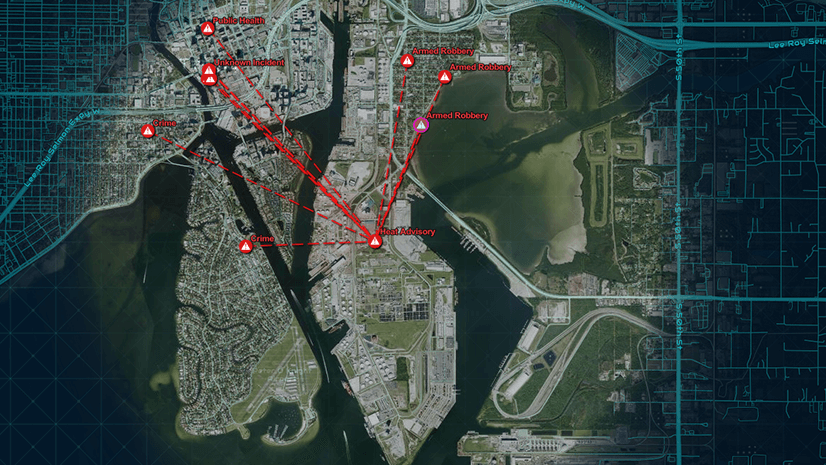
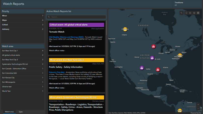
High-profile events require precision planning. This guide outlines a proven, location-centric strategy that uses ArcGIS technology to unify operations, data, and decision-making across jurisdictions. From mapping site perimeters and conducting 3D visibility analysis to enabling live threat dashboards and mobile field reporting, the technical paper walks through every step of a modern security workflow.

Plan security using indoor maps with the Special Event Operations solution for ArcGIS.

Highlights include:

– Digital twins and 3D basemaps for enhanced venue awareness
– Configurable dashboards for tracking real-time traffic, drone activity, and suspicious behavior
– Demographic and threat analysis to guide tactical planning
– Indoor mapping to support emergency response inside complex facilities
– Collaboration tools that break down silos across public and private agencies

These workflows aren’t theoretical—they’re operational. The technical paper presents a clear path for integrating GIS into your Security Operations Center (SOC) using commercially available tools and templates.

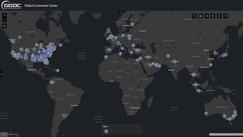
A Common Operational Platform for a Complex World

Security isn’t static. Threats evolve, crowds shift, and incidents can escalate in seconds. GIS brings everything together on one map, in real time, for all stakeholders—public safety, emergency management, defense, private security, and event organizers. It’s not just about seeing what’s happening. It’s about understanding it, anticipating what’s next, and acting fast.

This paper is essential reading for anyone tasked with securing venues, people, or infrastructure.

Download the full technical paper now and see how your team can build a proactive, intelligence-driven security strategy with GIS.

About the authors

Carl Walter is the Global Director of Homeland Security Solutions at Esri. He joined Esri in 2010, bringing over 20 years of experience in law enforcement and intelligence operations. Before joining Esri, Mr. Walter served as the Director of the Boston Regional Intelligence Center (BRIC), a DHS-designated intelligence fusion center, and as the Director of the Bureau of Intelligence and Analysis for the Boston Police Department. Following 9/11, he established a coordinated regional intelligence capability in the Boston metropolitan area, integrating local, state, and federal law enforcement alongside private sector resources. His efforts focused on critical event management, including preventing and responding to terrorist threats, man-made hazards, and violent criminal activity. In his current role at Esri, Mr. Walter develops global strategies that integrate technology, operations, and analytical tradecraft to support the security needs of national security agencies and Fortune 500 organizations worldwide. He holds an M.S. in Criminal Justice Management from the University of North Carolina at Charlotte and a B.S. in Criminal Justice from East Carolina University in Greenville, North Carolina.

Brian Lantz is the Director of Public Safety and Law Enforcement at Esri, where he leverages his extensive background in geospatial technology, data analysis, and operational security. With experience spanning the U.S. Secret Service and leading GIS companies, he operates at the intersection of advanced technology and high-level security operations. During his tenure with the U.S. Secret Service, Brian developed expertise in applying technology to complex national security challenges, using advanced geospatial solutions to enhance operational efficiency and protect critical assets. His time at Esri has further solidified his expertise in GIS, with a focus on spatial solutions that support law enforcement, emergency response, and defense applications. Brian has led efforts to integrate GIS technology into numerous security and government operations, ensuring its practical application in decision-making and crisis response. His ability to transform complex geospatial data into actionable intelligence has influenced policies and strategies across both the public and private sectors.

Next Article

Beyond Epi Info: Embracing the Next Generation of Public Health Analytics with GIS

Read this article