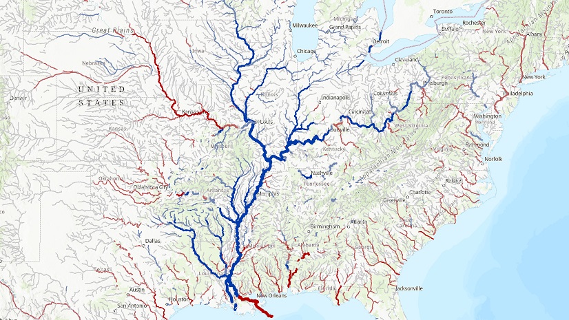
The development of a digital nationwide hydrography dataset began in the 1970s with the conversion of data from paper topographic maps. This data has provided the foundation for national hydrography data for decades. Over time, the data matured into what we know as the National Hydrography Dataset (NHD). This dataset included US Geological Survey (USGS) hydrography and eventually took advantage of capabilities within the National Elevation Dataset (NED) and the Watershed Boundary Dataset (WBD) to create NHDPlus and NHDPlus High Resolution. As technology advanced, demand for advanced capabilities grew. In 2023, the NHD was retired and the 3D Hydrography Program (3DHP) began. The 3DHP marks the beginning of the first comprehensive update for nationwide hydrography features since they were transferred from paper to digital maps.
Building a National Dataset
In the late 1970s, the first digital stream network, known as Reach File Version 1, was developed. Data was gathered using the USGS topographic state map series to deliver a 1:500,000-scale network. The network included stream names, an addressing system, catchments, and streamflow estimates. At the time, its use was restricted primarily to mainframe users. But, it created a vision that someday the data could be shared across the nation as a dataset supporting water resources management.
By the early 1990s, the Federal Geographic Data Committee began discussions that led to the inclusion of hydrography in the National Spatial Data Infrastructure. The USGS and the US EPA initiated a project to integrate the EPA’s Reach File stream network data with USGS hydrography. This collaboration leveraged water applications expertise within the EPA and the geospatial data production and maintenance infrastructure of the USGS. The result of this work is what we now know as the National Hydrography Dataset. The NHD project had a goal to develop and maintain a digital 1:100,000-scale stream network.

Development of Functionality
Development of the NHD continued to advance over the next three decades. By the late 1990s, the project team had automated integration of the EPA’s Reach File stream attributes and the USGS digital line graph hydrography. The US EPA, the USGS, and partners at the state level processed data using geographic information system (GIS) software and hardware to ensure data quality. In 2000, the hydrography data from USGS topographic maps was transformed into watershed-based surface water features.
As the production of the data neared completion, the transition to state stewardship began. And as technology improved and collaboration expanded, so did the NHD goals.

Extending Capabilities
In the early 2000s, the US EPA and the USGS wanted to support pollutant dilution modeling, which required extended capabilities such as calculating stream flow volume and velocity. This is what drove the development of NHDPlus, a suite of geospatial products that build on and extend the capabilities of the NHD, NED, and WBD.
Work started on the development of streamflow estimates and a high-resolution (1:24,000 scale) dataset (NHDPlus). Streamflow estimates required that local drainage areas be defined so that data such as precipitation and temperature could be related to stream segments. After a review of various methods for catchment delineation, it was determined that the hydrologically conditioned elevation-based technique produced the best results and was feasible to implement nationally. This method conditioned elevation data by trenching NHD streamlines and raising the WBD ridgelines in preparation for delineating catchments.
NHDPlus is widely used. The USGS and US EPA learned a lot about how water resources professionals wanted to use the data and how it could be improved. In 2012, NHDPlus version 2 was released. In addition to streamflow and velocity, NHDPlus provides value-added attributes, including stream order and a group of attributes that facilitate rapid stream network traversal and query. NHDPlus catchments are used to associate other landscape attributes, such as land cover, with stream segments. In 2022, NHDPlus High Resolution (NHDPlus HR) release 1 became available for download. NHDPlus HR presents a single, nationally continuous representation of all published NHDPlus HR Vector Processing Unit (VPU) datasets. An important addition to NHDPlus HR is a digital object identifier, which allows for citation of the data in scientific studies and reports.
Launching a 3D Hydrography Initiative
In 2021 the USGS began collecting feedback on a 3D national topography model and a 3D hydrography program. This initiative focused on updating and integrating USGS elevation and hydrography data into an integrated 3D model to deliver higher-quality data and support improved geospatial analysis.
In 2023 the NHD was retired and the initiative to remap the nation’s hydrography using high-quality elevation data was launched. The 3DHP replaces the NHD, WBD, and NHDPlus HR with a single product. 3DHP data includes lakes, streams, catchments, drainage areas, and other hydrologic features that have been derived from USGS 3D Elevation Program (3DEP) lidar data.
To kick off the 3DHP initiative, the USGS issued the 3D National Topography Model (3DNTM) Data Collaboration Announcement (DCA) about funding partnership opportunities for elevation and hydrography data acquisition. The DCA enables the public to identify partnership opportunities while at the same time providing federal agencies, state and local governments, tribes, academic institutions, and the private sector the ability to submit project proposals.
The development of data to support the 3DHP relies heavily on public-private partnerships to produce local data that meets rigorous standards that will be used to create a connected national network.

Local Data Connects the Nation
Local water resources professionals are needed to provide the expertise required for the creation of accurate hydrography data. State stewards across the nation are working to create high-quality 3D hydrography and contribute their expertise to the 3D Hydrography Program. The work being done at the local level is vital to the success of the program.

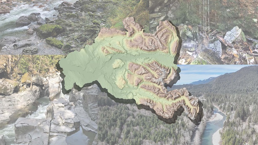
Washington Hydrography Dataset Program Pilot Project
Washington State has mapped hydrography for decades, and ongoing improvements in technology and analysis have advanced the accuracy of mapped data. Surface waters and their connected riparian zones are critical in supporting water quality and the health and diversity of aquatic and terrestrial species throughout Washington. Understanding the location of the state’s surface water is needed for assessing, monitoring, and protecting these ecosystems while improving climate resiliency at statewide, watershed, and local scales. The Washington Department of Ecology serves as the hydrography steward for the State of Washington, being a liaison between USGS and NHD users. In 2022, the department was funded to conduct a pilot project to identify the technologies, methodologies, datasets, and resources needed to refine and maintain the accuracy of the National Hydrography Dataset for Washington.
The Stillaguamish watershed (HUC8) in the Salish Sea basin was selected for the pilot project based on available lidar data, variety of topography, land cover, varying jurisdictions, and willing local participation. Before the launch of the project, USGS announced the 3D Hydrography Program. This required some changes in the project goals and direction. Instead of submitting data through the NHD process, project team members shifted focus to meeting the specifications for the 3DHP and determining if this would meet the hydrography needs of Washington stakeholders.
Using Arc Hydro Tools for Elevation-Derived Hydrography in Alaska
With the USGS high-resolution interferometric synthetic aperture radar (InSAR) mapping of Alaska completed in 2020, attention has turned to using the newly collected elevation data to refine the surface water network. As part of the USGS’s 3D for the Nation Program, updating the existing NHD to Elevation-Derived Hydrography (EDH), the USGS tasked Geospatial Products and Services Contracted (GPSC) firms to perform the updates. Given the vast area of Alaska, automation of the mapping was an implicit requirement for the task.
Dewberry, an Esri Gold Partner, quickly realized that the surface water tools previously developed and available in Arc Hydro were insufficient for the Alaska hydrography task. In a collaboration with Esri Water Resources, Dewberry subject matter experts worked to construct four new tools: two for flow line extraction and two for terrain feature identification. These tools are described in this publication by Alvan “Al” Karlin, PhD, CMS-L, and Dean Djokic, PhD.
Water Flows Where the Lidar Shows, or Does it?
The California Department of Water Resources (DWR) became the steward for the state’s portion of the USGS NHD in 2016. The state had identified the need to improve this authoritative surface water mapping dataset in California’s water action plan. Between 2016 and early 2023, DWR partnered with the Geographical Information Center (GIC) at California State University, Chico, and the Center for Geospatial Science and Technology (CGST) at California State University, Northridge, to update and improve the NHD using USGS standards, specifications, tools, and workflows.
Anticipating the shift from heads-up digitizing with aerial imagery to geoprocessing on high-quality elevation models to map surface water flow networks, the California hydrography stewardship team launched a pilot study to create a reliable workflow to generate USGS-compliant hydrography using a combination of tools. Using reference data provided by the Los Angeles County Department of Public Works along with lidar digital elevation models from the USGS 3D Elevation Program’s online data collection, the researchers at the GIC and the CGST developed tools to identify where barriers to flow in the lidar data need to be breached to represent where the water really is flowing on the upper Los Angeles River watershed landscape.
This ongoing pilot project is helping the team identify challenges, solutions, and next steps for data stewardship efforts. Testing continues on other parts of California’s varied terrain, and when the team is confident in the efficacy of the tools and methodology, it intends to publish and share them to enable participation by other collaborators in the build-out of 3DHP data coverage for California and beyond.
Hydro Feature Extraction in Minnesota
Minnesota, the Land of 10,000 Lakes and home to the headwaters of the mighty Mississippi River, has a long history that is tied to water and hydrography. From the early days of surveyors mapping the lakes, streams, and physiographic features across the state, the location of the features on the landscape have been mapped in more and more detail. As a result of progress in providing higher-resolution elevation data, technology is poised to develop higher-resolution hydrography and the hydrographic features across the vast Minnesota topography.
Minnesota also has a long history of a strong GIS community, both in developing tools and data and in collaborating. In 2017, a collaboration of dedicated GIS professionals created the 3D Geomatics Committee (3DGeo) under the guidance of the Minnesota Geospatial Advisory Council. The mission of 3DGeo is to identify and promote the need for the planning, funding, acquisition, and management of three dimensional geomatic data and derived products in Minnesota. In 2018, the 3DGeo created the Hydrogeomorphology Workgroup to promote the consistent development of Minnesota’s hydrography data and enable data exchange through coordination, cooperation, and standards development.
The 3DGeo and the Hydrogeomorphology Workgroup have been collecting current hydrography data as well as surveyed user input on needs that have or have not been met with current hydrology datasets. With the acquisition of new high-resolution lidar-derived elevation data across Minnesota, developing elevation-derived hydrography is the next step in honoring the Land of 10,000 Lakes and the many streams that crisscross Minnesota. A dedicated group is focused on bringing awareness to lidar-derived hydrography and the many benefits and applications of this 3D hydrography. This awareness and championing of high-resolution 3D hydrography will allow Minnesota to modernize its hydrography in greater detail.
About the author