Authored by: Jun Xiao, Enterprise GIS Administrator at Renewable Water Resources
Established in 1925, Renewable Water Resources (ReWa) is a nonprofit special purpose district that provides wastewater collection and treatment services for the Upstate region of South Carolina. ReWa’s mission is to enhance the community’s quality of life by transforming wastewater into renewable resources through responsible and innovative solutions.
Over the past few decades, ReWa’s service area has expanded substantially, and the organization has acquired new properties, all geographically dispersed throughout its service area to support its growing operations. The service area now spans Greenville County and portions of Anderson, Laurens, Pickens, and Spartanburg counties. Because of this growth, managing accurate and historically reliable property information across this region presented significant challenges, particularly when it came to maintaining historical property records that have changed ownership over many years. Much of the information existed only in institutional knowledge or was stored in boxes of paper documents, and without a unified and up-to-date property database, it was difficult to track and manage the properties.
To address these challenges, ReWa’s GIS team collaborated with multiple departments across the organization to develop a comprehensive and authoritative property inventory. This initiative aimed to create a centralized digital record of all ReWa-owned properties and establish a single, consolidated geographic information system (GIS) data warehouse for property information. As the project progressed, this GIS-based property data became the foundation for property inspections, environmental and habitat assessments, and long-term planning for public recreation and trail development.
Building the Property Inventory
Before this project, ReWa had no centralized digital record of its property holdings, and parcel information varied across county jurisdictions. The process began first with researching parcel data from all five counties within ReWa’s service area to identify every property owned by the organization. Information such as property boundaries, parcel identification numbers, purchase dates, and prior land use records were extracted from county parcel datasets to enrich existing property data. In addition, other related documents including deeds, easement agreements, and memorandums of understanding (MOUs) were also compiled and organized in a shared location. Each document was later linked to its corresponding property record in the GIS database, which could be accessed through a shared folder via URL.
In conjunction with the facility management coordinator, additional data fields were added to support future property condition inspections as well as environmental assessments. These fields included attributes related to the physical condition of gates, fences, and structures, along with environmental indicators such as floodplain presence, aquatic ecosystem areas, and greenspace existence and acreage. By incorporating both operational and environmental attributes, the inventory evolved from a static ownership record into a dynamic dataset capable of supporting a wide range of management and planning needs.
During the research and development process, several key challenges emerged. One in particular was the standardization of property ownership records, as some properties were still listed under ReWa’s former organizational name. In other cases, treatment plant sites were still in multiple small parcels that needed to be consolidated. The team also discovered that several pump stations transferred to ReWa were located on school or homeowners’ association properties without distinct parcel identification numbers. To ensure data quality, the GIS team held standing review meetings with the engineering right-of-way coordinator and the facility management coordinator to verify property information and identify issues that needed to be addressed.
Through this effort, ReWa established an authoritative property inventory that now includes 177 properties totaling approximately 1,883 acres. This inventory has provided the organization with its first comprehensive overview of all land assets to establish the foundation for subsequent stages of the land management initiatives at the company.
Integrating into the Asset Management System
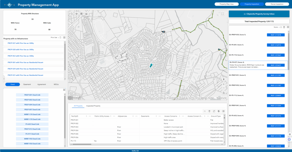
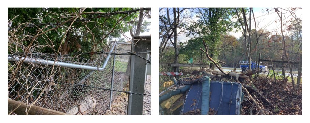
With the property inventory established, the next step focused on integrating the GIS data into the organization’s asset management system to support routine property inspections. At this stage, GIS played a pivotal role in connecting the property GIS data with the computerized maintenance management system (CMMS). The asset management team worked closely with the facility management team to develop property inspection templates that aligned with the attributes defined in the GIS database. These templates ensured field staff consistently recorded property conditions and observations, including potential hazards, site signage, and any evidence of illegal dumping. To maintain data synchronization, the GIS team developed a daily scheduled SQL script that automatically overwrites inspection data back into the GIS database.
After these integrations were completed, the GIS team developed a Property Inspection Dashboard using ArcGIS Experience Builder to make the data easily accessible and actionable across the organization. The dashboard provides an interactive view of inspection progress, property observations, and conditions in real time. Users can filter inspections by property condition score and quickly prioritize areas requiring follow-up. Each property record includes direct links from the GIS environment to the corresponding inspections within the asset management system, enabling seamless navigation between inspection data and maintenance actions. The dashboard has become a central tool for management and field coordination. Supervisors use it to monitor inspection progress and identify maintenance priorities, while field teams rely on it to verify property details and update inspection records.
Supporting Environmental Assessment and Land Revitalization
To better understand the environmental characteristics of its properties, the GIS team performed a series of spatial analyses using FEMA floodplain data, the National Land Cover Database (NLCD), and wetland datasets. The analyses quantified the environmental composition of each property, identifying areas influenced by floodplain coverage, aquatic habitats, and greenspace. Across ReWa’s 177 properties, the results showed 124 aquatic ecosystem areas, 714 acres of floodplain, and 1,413 acres of greenspace. These findings now serve as the foundation for field-based environmental assessment efforts led by the watershed and natural resources team with support from the GIS team. It supports water quality improvement projects—such as land protection, wetland and riparian restoration, stormwater and green infrastructure best management practices, and streambank stabilization—by providing reliable property and environmental information.
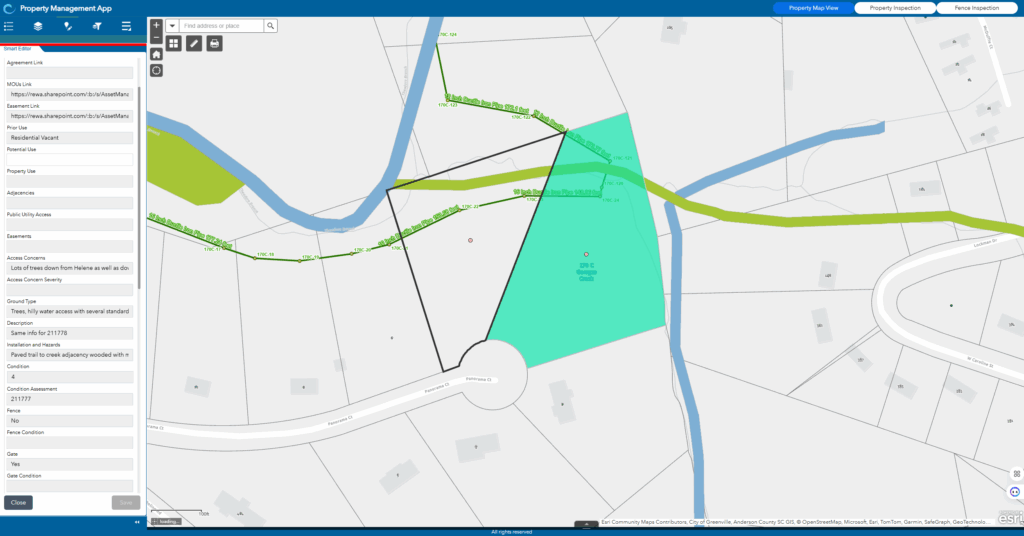
Most recently, to support ReWa’s land revitalization initiatives, the GIS team developed the Property Map View application. This project integrated many of the property inventory and asset management integration system components into a new collaborative effort. With the Property Map View, managers and land management consultants can navigate geospatial data of property/land assets throughout ReWa’s entire service area, conduct land use assessments, and determine future land use plans. The application provides query, filter, and field edit functions that allow users to access property details, review environmental characteristics, and record assessment results directly within the GIS platform. By integrating environmental data, operational information, and planning tools into a single spatial environment, the application supports informed decision-making, promotes collaboration, and helps identify opportunities for restoration, repurposing, and community-focused development.
Through the land management initiative, ReWa has transformed how property information is collected, managed, and shared across the organization. What began as an effort to centralize property records has evolved into a comprehensive GIS framework that supports asset management, environmental assessment, and land revitalization. By integrating data from multiple departments and systems, ReWa has created a unified platform that improves efficiency, strengthens collaboration, and supports data-driven decision-making. This initiative not only enhances ReWa’s ability to maintain its property asset portfolio but also advances its mission of environmental stewardship and community engagement. As ReWa continues to build on this foundation, the organization plans to expand the use of GIS to further support sustainable land management, promote public access to natural spaces, and ensure that every property contributes to the health and vitality of the community.
“ReWa’s GIS-based property inventory and management application gives leaders a clear, up-to-date view of all properties, making it easier to manage maintenance, plan for the future, and make informed investment decisions. By bringing together environmental, operational, and inspection data, it helps guide smart, practical choices that benefit both the organization and the community.” –Julie Dacus, Director of Business Services, Renewable Water Resources (ReWa)
About the Author
Jun Xiao is the enterprise GIS administrator at Renewable Water Resources (ReWa). She leads the administration, maintenance, and optimization of ArcGIS Enterprise, focusing on system architecture, automation of geospatial workflows, and integration with asset management and operational systems. Since joining the utilities industry in 2018, Jun has specialized in applying GIS technology to enhance wastewater utility operations, data governance, and disaster response. She holds a master’s degree in geospatial systems engineering from Texas A&M University–Corpus Christi, where she developed a strong foundation in spatial data management and geospatial system design.
For more information, contact Jun Xiao at JunX@re-wa.org.

Stay Connected with Esri’s Water Team
ArcGIS is an extensive information system that enables modernization of workflows with easy-to-use applications for the field and office. Strengthen your organization with smart water solutions that will increase efficiency and provide insight for decision-makers.
Visit the Esri Water Utilities web site for more information.
Join the Water Utilities Community
Follow #EsriWater on social media: X| LinkedIn
Subscribe to the Water Industry newsletter “Esri News for Water Utilities and Water Resources“