The Field Museum in Chicago uses GIS (geographic information systems) to engage local communities in monarch butterfly research and protection.

Monarch butterflies are amazing creatures. They are instantly recognizable with their brilliant orange and black wings. They also perform marathon migrations across the North American continent – the eastern monarch population (east of the Rocky Mountains) travels an astounding 4,000-to-5,000-kilometre journey – one of the world’s longest insect migrations. And they contribute to the health of our planet. Monarchs are a flagship prairie species: Prairie habitat is important to pheasants and other animals dependent on grasslands and wildflowers, which have complex root systems that help filter water, reduce runoff, and control erosion. They are also a flagship conservation species: While feeding on nectar, they pollinate many types of wildflowers, and are an important food source for birds, small animals, and other insects.

A Precipitous Decline in Monarch Butterfly Populations
Monarch butterfly numbers are dropping significantly, due to habitat loss, deforestation, loss of plants (for nectar and for laying eggs), climate change, and exposure to pesticides. According to the U.S. Fish and Wildlife Service, scientists have noted steep declines in North American monarchs overwintering in Mexico and California. Numbers in the larger eastern population are measured by the size of the overwintering roosts in Mexico; it is estimated that the population fell from 384 million in 1996 to a low of 14 million in 2013; the 2019 population was about 60 million. The western population, located in California, saw a more precipitous decline, from about 1.2 million in 1997 to fewer than 30,000 in 2019. The U.S. Fish and Wildlife Service finds the Endangered Species Act Listing for the monarch butterfly “warranted,” but precluded for now.
Urban Wildlife Habitats: A New Way to “See” the City

Over 50% of the world’s population lives in urban areas, and that number is only expected to grow (World Bank). The world’s cities cover only 3% of the Earth’s land, but consume 60-80% of manufactured energy and are responsible for 70% of carbon emissions. According to the IUCN, although cities pose a significant threat to biodiversity and habitat loss, they can also support species and biodiversity conservation. The Keller Science Action Center at the Field Museum in Chicago is researching the vital role cities, and the people that call them home, can play in conservation and ensuring biodiversity. Specifically, they are examining the role of monarch butterflies as pollinators in cities, and also a new way of “seeing” the city from the perspective of the monarch. This includes assessing the role cities could play in helping to increase the amount of habitat available to support eastern monarch butterflies, and to identify best practices for engaging a diversity of urban stakeholders in the creation of monarch habitat.
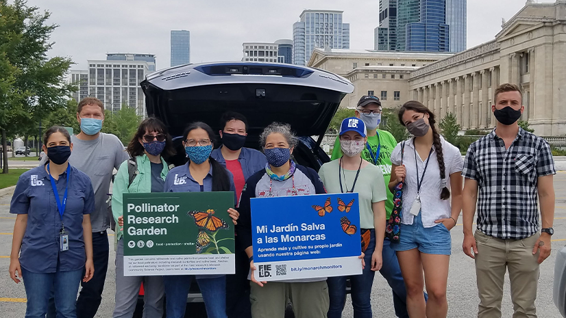
Field Museum Chicago: Where Science and Community Action Come Together
An important part of the Field Museum’s monarch butterfly research and conservation work seeks to understand the motivations, concerns, interests, and challenges of diverse stakeholder groups, and to directly integrate community action. The project team implemented community science programs around Chicago, and developed resources that anyone can use to help monarchs and other pollinators. Monarch butterflies lay their eggs on milkweed, and milkweed is the only plant that monarch caterpillars can eat. Residents in and around Chicago participate by monitoring milkweed for monarch eggs and caterpillars in home gardens and in natural areas around schools, offices, parks, and roads.

A GIS Workflow to Engage the Community
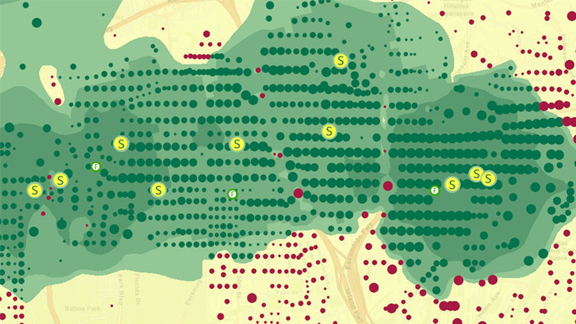
Suitable Plantable Space: The first step for the team at the Keller Science Action Center was to study suitable milkweed planting space by land use type. Within cities like the Chicago metro region, they found that residential areas can be a significant contributor of milkweed due to the availability of plantable space (defined as grassy or shrubby habitat where milkweed can be grown) as well as the enthusiasm of residents to plant milkweed and provide habitat for monarchs.

Online Hub as Center of Activity – The team built an ArcGIS Hub to provide educational tools, inspiration, and background information. This is where community members sign up to be part of the effort, so they can RSVP for training sessions and access data surveys based on ArcGIS Survey123.
The combination of Survey123 and ArcGIS Hub enables us to improve how we communicate and collaborate with our participants, making the process easier for both us and them and also keeping them engaged throughout the summer.
Through the ArcGIS Hub, community members can:
- Join the Hub: Sign up for a free ArcGIS account.

- Watch a Training: Sign up for virtual or in-person training sessions to understand milkweed plants, monarch eggs, etc.

- Report on Their Site: Use Survey123 to capture data and share photos about milkweed patches.

- Monitor Their Patch: Monitor the milkweed patch and use Survey123 to record observations each week.
- See Live Results: Data is presented in multiple formats: Numerical, graphical, maps, and photos. Participants can upload and view the community’s photos of butterflies, caterpillars, monarch eggs, etc. arranged by album. Data on the number of participating sites, milkweed patches, total eggs, and other indicators, is shared live (as it becomes added).

I’ve been with the monarch butterfly project since it started in 2019. I started this process by planting a milkweed patch on the side of my house. This project fit right into our ongoing conversion of the majority of our suburban yard into flower beds of native species plants since 2015. I monitor my milkweed patch and use the survey tool to upload my data. I love connecting with fellow enthusiasts and feel like I’m making a difference in reducing the effects of climate change.
What do the results mean?
Through this project, the Keller Science Center is learning more about the monarch population that migrates through the Chicagoland area each year as well as characteristics of patches that were more or less successful in supporting monarch eggs and caterpillars. The interactive graphs below show changes in the number of eggs and caterpillars seen throughout the summers of 2019 and 2020. The table below describes some of the characteristics that appear to influence the “success” of an urban milkweed patch.


Explore Resources for Nonprofits
- Find out more about the Monarch Community Science Project at the Keller Science Center at the Field Museum in Chicago and explore their ArcGIS Hub.

- The Esri Nonprofit Organization Program provides low-cost access to data, technology, and resources to help nonprofits advance their mission.
- Sign up for the Esri Nonprofit & NGO eBrief to get community news.
- Follow us on Twitter @Esri_Nonprofit.
- ArcGIS Hub is an easy-to-configure cloud platform that organizes people, data, and tools to accomplish initiatives and goals.
- ArcGIS Survey 123 is a simple and intuitive data gathering solution to create, share, and analyze surveys in just three easy steps.