Customer Spotlight Story
Duquesne Light Company (DLC) is located in Pittsburgh, Pennsylvania. For over 100 years, it has been providing safe and reliable electric service to the people in southwestern Pennsylvania. The company serves more than 600,000 customers. DLC is committed to safely powering its customers’ lives while playing a leading role in the region’s clean energy transition.
DLC’s vision is to create a “larger-than-light,” clean energy future for all, with an emphasis on delivering exceptional results today and boldly harnessing opportunities for tomorrow.
CHALLENGE
Traditionally, the distribution grid supplied power to homes and businesses. However, with the rise of electric vehicles, smart cities, microgrids, and energy producers who also use power, we need new infrastructure and new ways to manage data. DLC lacked an effective connected system model to support and integrate its outage management system (OMS) and other digital systems.
DLC aimed to support its grid modernization efforts, improve field communication and workflows, and meet the needs of a large and diverse customer base. To better serve its growing clientele and enhance communication with customers, the company initiated a grid modernization strategy that included implementing an outage management system (OMS).
SOLUTION
DLC embraced an enterprise-wide approach to modernize its network management, embarking on a transformational journey to digitize its business processes. The aim was to create a sustainable system with proper governance.
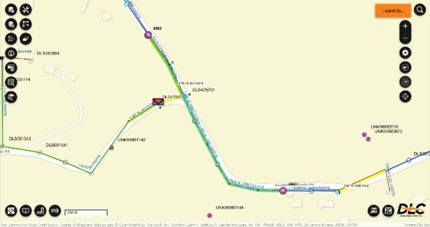
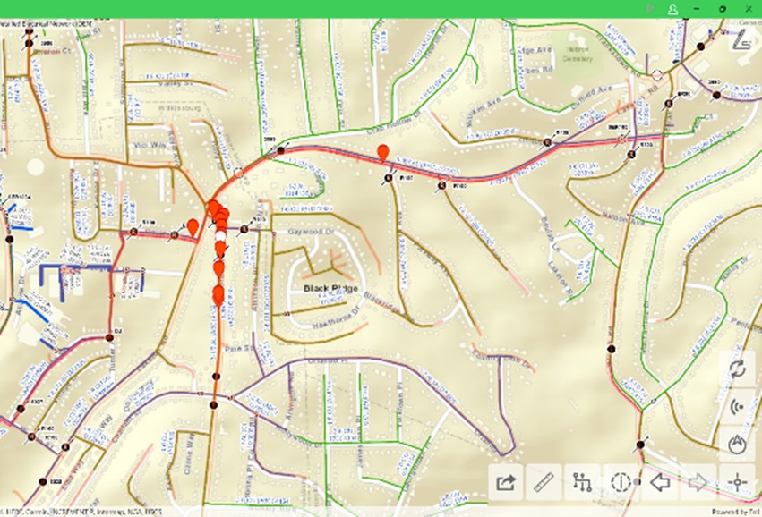
Isolation trace details a segment of aerial cable.
The screenshot illustrates the results of a trace in Schneider Electric’s ArcFM Solution XI Series showing how to isolate a segment of aerial cable by running a custom-configured “is connected” trace.
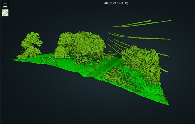
Lidar image of the location of the isolation trace.
The lidar viewer of the data shows the trace starting location. Note that the transmission lines also appear in the lidar. This service is hosted by GeoDigital and is integrated into ArcFM Web XI via a pop-up configuration in the Esri-based web map and portal-to-portal collaboration with GeoDigital. These images demonstrate ArcGIS capabilities in action at Duquesne Light Company.
The grid modernization team gathered stakeholders from various departments, including the control room, field crews, engineering, GIS, and others. They explored integrations with Advanced Distribution Management System (ADMS), Operations Data Management System (ODMS), Eaton CYME, and Safe Software FME. By collaborating across departments, they gathered requirements, modeled the data, and tested integrations early in the process.
To support their goals, DLC utilized ArcGIS Utility Network and Schneider Electric’s ArcFM Solution XI Series products to establish a robust connection model. This solution ensures all critical systems can communicate and share data seamlessly. A key feature, ArcFM Feeder Services, enhances this connectivity by facilitating data exchange between various systems, ensuring they work together and remain synchronized. Additionally, ArcFM Editor offers editing and management tools that help maintain the integrity of asset and ArcGIS Utility Network data, ultimately boosting productivity and operational efficiency.
The utility integrated various systems, including ADMS, ODMS, engineering workflows, and advanced metering, to ensure reliable real-time data exchange and operational efficiency. Maintaining high data accuracy across its vast and evolving infrastructure was crucial. The previous practice of regularly extracting data to feed these systems was burdensome for both personnel and servers. Additionally, this foundational approach supported multiple downstream internal customers. Teams in distribution planning, engineering, streetlight management, and metering utilize ArcGIS Utility Network information for analytics and the Azure platform. With the ArcGIS Utility Network and ArcFM Feeder Services, other departments can extract data in real time from the Azure environment. This has eliminated the manual process and the need to request data extracts.
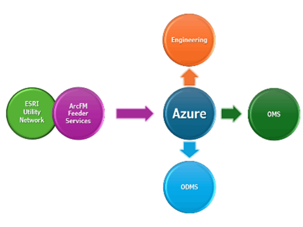
Process flow chart.
The flowchart highlights the role of ArcFM Feeder Services in pulling data from ArcGIS Utility Network and making it available, via Microsoft Azure, to other systems. By facilitating the seamless transfer of GIS data to systems such as engineering, outage management systems and operational data management systems, DLC ensures efficient data flow and enhanced operational coordination across the enterprise.
The decision to implement Esri software was based on its reputation as the leading GIS provider. DLC adopted ArcGIS Pro and ArcGIS Enterprise to tackle various challenges, enhancing the customer experience with outage notifications and improving reliability through IT integrations. Additionally, DLC utilizes Schneider Electric’s ArcFM XI series products, serving over 800 users, including approximately 250 mobile users.
ArcFM Mobile enables field personnel to access, view, and mark up data directly in the field. This ensures that DLC’s downstream systems are updated with the most accurate information. GIS editors review and finalize field-collected data, implementing changes in downstream systems to enhance efficiency and reliability, ultimately supporting informed decision-making.
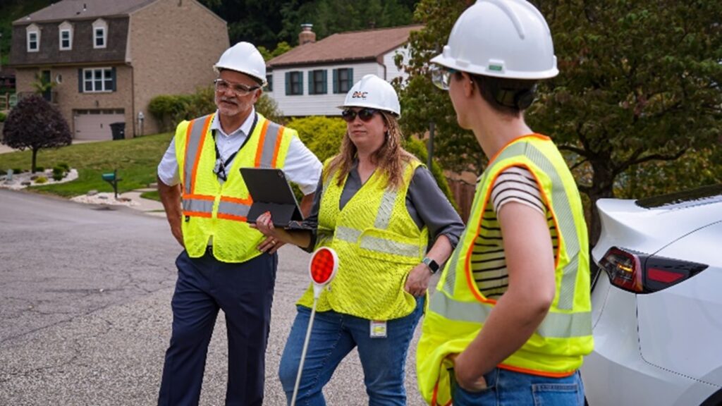
The implementation team is observing field crews.
Jennifer Smith, Duquesne Light Company Product Owner, with Duquesne Light Company IT support staff, Robert Pappaterri, Operations Systems Specialist, and Emily Foster, Systems and Software Analyst, work with and observe field crews to improve the ArcFM Mobile product experience.
ArcFM Mobile identifies work areas and operational locations.
ArcFM Mobile C1 2025 on Windows illustrates the “identify” operation on an overhead switch bank on DLC’s detailed operational map. In this map, the subnetwork (circuit) is highlighted by the identity, and line features are symbolized by their operating voltage.
PARTNER
Schneider Electric is DLC’s technology and implementation partner. The ArcFM Solution Series is the most comprehensive set of utility-specific GIS applications built to fully digitize and automate the updating and maintenance of the GIS. ArcFM bridges the gaps between siloed data, disconnected workflows, and isolated systems, ensuring network assets are accurately modeled to feed critical systems.
RESULTS
The solution has been well received by employees, with significant daily engagement from both mobile and web users. It integrates seamlessly with existing systems, enhancing capabilities in distribution planning, engineering, and analytics.
The deployment of ArcGIS Utility Network significantly enhanced DLC’s operational capabilities and data management processes. By integrating critical systems such as ADMS and AMI (Advanced Metering Infrastructure), DLC can now share real-time information, enabling faster responses and improved decision-making. Recent analyses have shown an impressive 99 percent data accuracy, demonstrating the reliability and precision of DLC’s geospatial data infrastructure. The use of GIS editing, data sharing, and mobile solutions has streamlined operations. Additionally, capturing work redlines electronically in the field is a valuable part of the daily workflow.
“ArcGIS Utility Network and ArcFM have significantly enhanced our operational capabilities. The seamless connectivity and data accuracy provided by these solutions are instrumental in maintaining the reliability and efficiency of our electrical infrastructure. This is a crucial step forward in our commitment to providing top-notch services to our customers.”– Alan Hope, ADMS Program Manager, Duquesne Light Company.
BENEFITS
Other process workflows, such as version control and data validation, were significantly streamlined for employees. The DLC grid modernization team facilitates data sharing by ensuring that accurate and reliable information is easily accessible. This data is automatically and clearly transmitted to key departments, including engineering, metering, and the control room. Other DLC departments are experiencing immediate benefits from the ability to access real-time, time-stamped data, which helps inform critical decisions, support essential systems, and enhance customer service for their growing customer base.
Over time, the solution enhanced business performance by enabling advanced analytics, improving scheduling and work coordination, and increasing situational awareness during storm events.
NEXT STEPS
DLC plans to expand the implementation to include additional assets such as substations and transmission facilities.