Co‑authored by:
Bruce Jumper, Partner Advisor, Trimble
Permitting as a Foundation for Community Success
Today’s communities are dealing with intense competition for economic development. Whether it is housing, jobs, schools, parks, transportation, broadband, or other infrastructure, these components are critical to the success of a community. One of the most important hurdles for all economic development is the permitting process.
All communities need to ensure that the permitting process is accurate, efficient, transparent, and compliant. Quite often this vital process is lacking in one or more of those factors and ends up being a liability, rather than a strength. If your community wants to win the economic development contest, it needs innovative and effective permitting, often leveraging people, technology and processes to achieve desired effect.
The Importance of Location
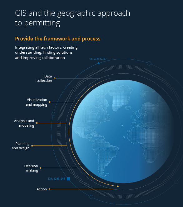
The permitting process is driven by location. The project’s location determines what agencies are involved, the environmental constraints, infrastructure impacts, and applicable zoning and land use.
How effectively a permitting system uses this geographic context often determines whether projects move forward smoothly or stall. GIS (Geographic Information System) provides the foundation needed to understand and manage these spatial relationships with clarity and confidence.
Familiar Challenges Facing Permitting Teams
Research shows the most common permitting challenges are:
- Inefficiency – 70% of municipalities report that permitting processes are inefficient and outdated, creating delays and unnecessary administrative burden.
- Poor public perception – 62% of the public find the permitting process overly complex and difficult to navigate, leading to frustration and reduced trust.
- Lack of regulatory compliance – Manual processes and inconsistent documentation expose agencies to compliance gaps, with $1M in average annual fines on compliance failures.
The Solution: A Stable, Geographic Approach
Communities must implement permitting systems designed to mitigate these challenges. The technology landscape for government agencies looking for the right solution is constantly changing. Startups, mergers, and acquisitions are a key part of that uncertainty. Navigating this search for the right vendor and technology to implement and support this significant enterprise business system is daunting. There is an answer, and it resolves those instability concerns.
Esri® and Trimble® are two of the most tenured, credible and dependable vendors in the government technology space. Together we have been in business for more than 100 years, and partners for more than 25 of those years having defined, developed, and led the industry for decades. We bring stability, dependability, longevity, innovation, and dedication to the success of our customers required to deliver and support enterprise business systems like permitting. Our solutions do not just solve problems; they simultaneously improve the organization and enhance the community.
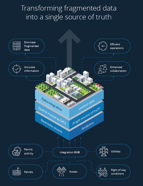
Trimble Unity Permit Powered by ArcGIS
Permitting is a location-based workflow. Starting with Esri, ArcGIS®, the world’s most powerful GIS software, as the mission-critical, enterprise IT business system that turns location data into insight, powering better decision-making and delivering significant business value. Then add in Trimble Unity Permit designed to work with ArcGIS mapping and spatial capabilities, you then have a paperless, GIS-based permitting system that solves the familiar challenges and maximizes the insight of the geographic context for each permit.
Addressing Core Permitting Challenges with Esri and Trimble
Together, Esri and Trimble help agencies address core permitting challenges:
- Inefficiency – Streamlined digital workflows improve efficiency, reduce errors, and promote improved decision‑making.
- Poor public perception – Stakeholder coordination allows residents, contractors, and others to submit and track applications online through a user‑friendly portal.
- Lack of regulatory compliance – Built‑in compliance and reduced liability automatically enforce required steps, apply location‑based rules, and create audit‑ready records that protect agencies from costly compliance gaps.
Turning Permitting into a Competitive Advantage
Whether you already have a permitting system, or your permitting process is still manual and based on paper, PDFs, and/or spreadsheets, you cannot afford to ignore this chance to extend your investment in Esri ArcGIS and adopt Trimble’s GIS-based permitting solution to turn your permitting process into a competitive advantage that
- Integrates the spatial context into every decision
- Facilitates departmental coordination
- Enables digital service delivery
- Provides permit stakeholders with online services, transparency, and real‑time updates
- Delivers a data foundation ready for advanced technology like AI and digital twins
- And increases revenue
Modernizing with Esri and Trimble provides the confidence, clarity, and digital services communities expect—and positions agencies for the next generation of technology.
As One Public Works Leader Shared:
“Using Esri and Trimble together improved our visibility and communication across teams by giving us consistent GIS based information.”
Tammy Wambeam, GIS/IT Administrator, Salt Lake City, Utah Department of Public Utilities
Ready to Fast‑Track Infrastructure and Development Projects?