“If you are leaping a ravine, the moment of takeoff is a bad time to be considering alternative strategies.”
-John Cleese
The timeliness of this blog is not lost on yours truly. As I type this, Hurricane Zeta is barreling up the Gulf of Mexico towards me…the third in the Gulf in less than six weeks.
One of the aspects of resilience planning that I’m drawn to is the fact that the priorities and approach of planners across the world will be different. The guiding principle of resilience planning is being proactive in enabling communities to thrive in the face of acute shocks and chronic stresses. Acute shocks are usually in the form of natural disasters, civic unrest, or perhaps most visibly this year, a global pandemic. Chronic stresses occurred over a longer period and won’t be fixed overnight. They include homelessness, lack of economic opportunity, aging infrastructure, and poor transit.
The convergence of these factors will likely affect the very potential of a community to proper, grow and be a safe and healthy place for all its citizens to thrive. Since location is a factor in every aspect of resilience planning, GIS is a mission-critical system in developing these strategies. GIS provides the tools to create and analyze designs, collaborate with stakeholders, and justify policies that make communities resilient in both the short and long term.
It’s becoming a more common situation for cities, counties and states to establish resilience plans for the unique challenges they face now and anticipate facing in the future. Chief Resilience Officer, Director of Resilience Strategies and other similar titles were unheard of at the government level a dozen years ago. Now, they are almost expected. If this concept seems foreign to you, or you think you’re behind in understanding what this would look like in your city, take a look at the plan for the city of Tallahassee, Florida. Fernleaf Interactive was their partner in developing this plan.
The capital city of Florida established that resilience in their community revolves around four main goals: public safety and preparedness, hazard mitigation and climate adaptation, equity and social cohesion, and planning and integration. As mentioned earlier, GIS plays an unmistakably large role in this process. Check out this graphic from the city’s timeline:
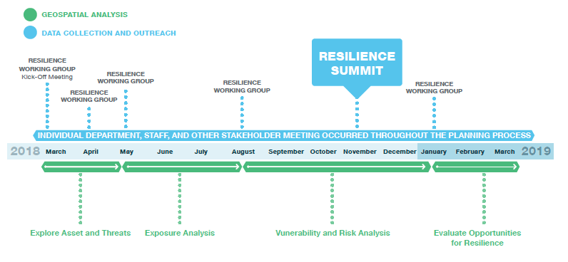
From start to finish, geospatial analysis, along with public outreach and data collection, is a part of the process. GIS is at the center of all of that. As a planner, or even a GIS manager, this necessity has to be at the forefront of your thinking, because if you’re not making data-driven decisions, you’re making anecdotal decisions. Anecdotal evidence is easy to marginalize or even dismiss.
It’s not enough to say, “Well, we had some floods before. We should probably prepare for them again.” Where were the floods? Why did they happen? Have they intensified over time? What businesses, residences, parks, etc. would be affected by another 50-year, 100-year, or 500-year flood? What future development do we have slated that could be impacted?
It’s not enough to say, “Well, we’ve got a lot of blight in this neighborhood. We need to redevelop the area.” Why and where did the blight occur? Where would redevelopment have the greatest impact, especially on the most disadvantaged? What conditions still exist that would slow or stall the success of this redevelopment?
In addition to managing acute shocks and mitigating chronic stresses, GIS provides solutions for community leaders to:
- Assess and Monitor Conservation and Preservation Activities
- Support Economic Sustainability Planning
- Promote Social Equity & Healthy Communities
- Analyze Green Infrastructure Impact
- Mitigate and Remediate Blight and Stabilize Neighborhoods
- Establish Measurable Indicators for Transparency and Accountability
If you’re working in the ArcGIS platform, here are some essential apps that you’ll want to leverage when tackling resilience planning. These are all web-based and easily accessible for planning (as well as GIS) professionals:
ArcGIS Solutions for Resilience: Ten free configurable maps and apps that provide tools for community engagement, business resilience, community hazard assessments and more.
Performance Management: – These configurable, open source apps can be used by government agencies to monitor key performance metrics and communicate progress made on strategic outcomes to the general public and other interested stakeholders. You can get started with this link.
Survey123: – This is one of the simplest and more powerful ways to start the community engagement process. Citizens can access your intuitive surveys on any device, providing you with spatially-referenced feedback.
Effective resilience planning, whether you’re starting with planning for the next flood, hurricane or wildfire, or working towards a capital improvements plan or economic recovery effort, must begin and end with GIS. It must be focused on authoritative data, pertinent geospatial analysis, and consistent community engagement. For planning professionals, this doesn’t just sit on the shelf as a separate plan. It becomes a part of your community’s long and short-range planning initiatives.