One of the interesting developments in community planning that’s occurred in the last decade or so is the expanding role of planning professionals. Specifically, I’ve personally seen planners intricately involved in resilience planning exercises, from the 100 Resilient Cities program in Nashville to flooding mitigation in Memphis to hurricane preparedness and recovery in south Alabama. You would be hard-pressed to find a more prevalent acute shock that planners must deal with today than the COVID-19 pandemic.
Initially just a public health crisis, this has quickly evolved into one with enormous planning and economic ramifications, as well.
First, we’ve seen the trend of counter-urbanization continuing to grow. We touched on this concept in an article earlier this summer, and this trend shows no signs of slowing. I believe counter-urbanization is fed by two drivers. The high cost of housing for many that chose to live in urban areas was offset by the cultural, social, and physical amenities available to them. Many of those are no longer available, or available in very limited aspects. This is also tied to the fear of the pandemic spreading faster in tighter, congested areas. There have been studies that argue against this, but sometimes perception is reality, and many urban residents feel they would be safer in a less crowded environment. The other driver is that the work-from-home phenomenon has evolved from a temporary to a long-term (if not permanent) solution for many companies. Therefore, we’re seeing employees that moved to urban areas for their job no longer finding themselves tethered to their location. Again, couple this with higher housing costs, and it becomes less appealing for many to stay in their urban location. Planners in urban areas may soon be dealing with more vacant residences and mixed-use developments. There may be opportunities to influence policy towards using these areas for more affordable housing. This would need to be tied to an economic mobility strategy, which we’ll go into more detail later. In suburban and rural areas, planners are going to need to plan for changes in their growth capacity. Web-based apps like ArcGIS Urban and the Policy Validation App allow planners and administrators to play out different development policy scenarios and measure the impact of added residences.
Second, it’s become more critical than ever for planners to coordinate with economic development professionals in the wake of this pandemic. This means updating zoning and land use policies to accommodate more open streets and update curb management policies. The retail and restaurant markets are not going to look like they did in January any time soon…and probably not completely until a vaccine is readily available. So, planners and EDOs need to work together to identify the best short and long-term policies that can empower small businesses to thrive (or at the very least, stay afloat), particularly in denser areas where they’re trying to offset counter-urbanization.
There are three main facets to economic restoration and development where planners and GIS need to be involved:
- Economic Policy Development
- Analyze and understand community demographics and socio-economic characteristics
- Prioritize workforce development needs.
- Develop sustainable policies for economic mobility in neighborhoods
- Identify gaps in commercial services for neighborhoods.
- Promote equity in economic opportunities for your community.
- Communicate policy guidelines to administrators, the public, and business community for review.
- Business Retention and Expansion (BRE)
- Identify and analyze demographic and socio-economic variables for neighborhoods to assess needs.
- Evaluate and visualize site selection for both new businesses and expanding businesses.
- Generate market analysis for sustainable growth.
- Collaborate securely internally and externally the needs of businesses and the community.
- Reduce costs of attracting new businesses by streamlining recruitment workflows through a data and location-driven approach.
- Destination Branding
- Identify and analyze demographic and socio-economic variables for neighborhoods to assess needs.
- Evaluate and visualize site selection for both new businesses and expanding businesses.
- Generate market analysis for sustainable growth.
- Collaborate securely internally and externally the needs of businesses and the community.
- Reduce costs of attracting new businesses by streamlining recruitment workflows through a data and location-driven approach.
Let’s take a look at a couple of examples of this.
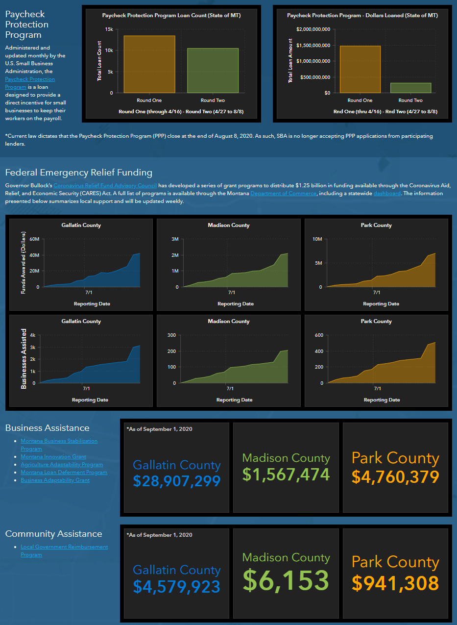
Bozeman, Montana is using an ArcGIS Hub Recovery Dashboard that provides transparency to the public and business community about federal, state and local funding, unemployment, housing assistance and more, and breaks it down by county (the city is in three counties).
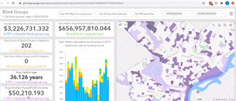
Philadelphia is using a dashboard to show that their economic development investments are meeting demographic, social and racial equity needs.
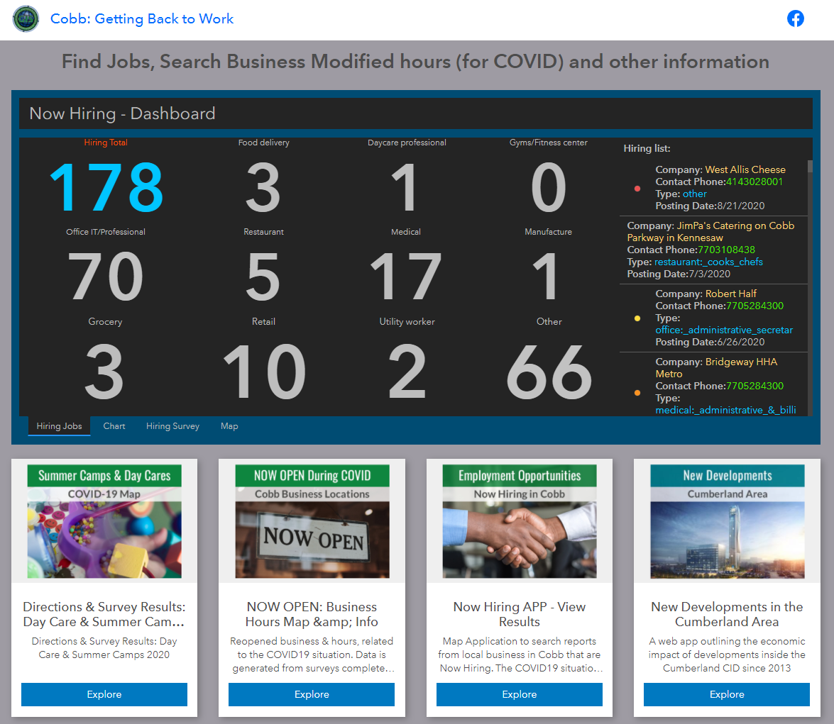
Cobb County, Georgia has deployed an Economic Restoration Hub that provides comprehensive business and employment data for businesses and the public to understand where and what types of jobs are available and to understand where business and workforce needs are in their county.
There are other great examples from Tallahassee, Florida, Seattle, and many more.
The bottom line is that successful resilience planning, particularly economic restoration, doesn’t happen without dedicated planning professionals that leverage the power of location through GIS to design, analyze, and visualize a sustainable and equitable development strategy.