Any conversation planners and administrators have today about community resilience has to include a sustainable housing policy, and a key component to that policy has to be access to affordable housing. According to a 2019 study from Habitat for Humanity, 1 in 6 households in the United States are paying more than half of their income on housing. Of that group, more than half are renters earning under $30,000 annually. At the core of this crisis is fewer new homes being built, particularly starter homes. This circumstance, in turn, lifts rent and home pricing at a rate faster than income growth.
The role of the planning professional in a sustainable, affordable, and equitable housing policy and design is more critical than ever. When people are not able to afford to live in the community in which they work, it can result in undesirable sprawl in surrounding communities, and even with an excellent transit system, increased traffic on roadways. Implementing policies for sufficient affordable housing provides many benefits for communities, including increased spending power, more educational opportunities, job creation and economic mobility, growing municipal revenue, lower stress on transportation networks, and reduction of poverty by ending the cycle of homelessness. GIS plays a crucial role by empowering planners in three main areas: taking a location and data-driven approach to developing a sustainable policy for housing, evaluating and designing equitable and attainable affordable housing, and architecting a path of economic mobility for poorer and disadvantaged residents.
Housing Policy Development
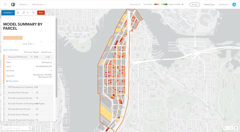
Planners and policy makers must be able to define the need, benefits, and challenges in assigning areas for affordable housing. This directly impacts other policies, such as mitigating homelessness and improving overall quality of life. Taking a data-driven approach, planners can develop multiple housing scenarios in neighborhoods and measure their potential effectiveness using apps like ArcGIS Urban and the Policy Validation App. Policy makers can then evaluate and visualize these scenarios, collaborate with community leaders, and engage the public to meet their expectations for transparency and accountability. Specifically, the role of GIS empowers planners to:
- Identify and analyze demographic and socio-economic variables for neighborhoods to assess needs.
- Allocate percentages of development to affordable housing as part of a comprehensive plan
- Evaluate accessibility to essential services, such as transit, education, health care and more.
- Understand the impact of homelessness in the area.
- Communicate policy to stakeholders and monitor feedback.
Designing Affordable Housing
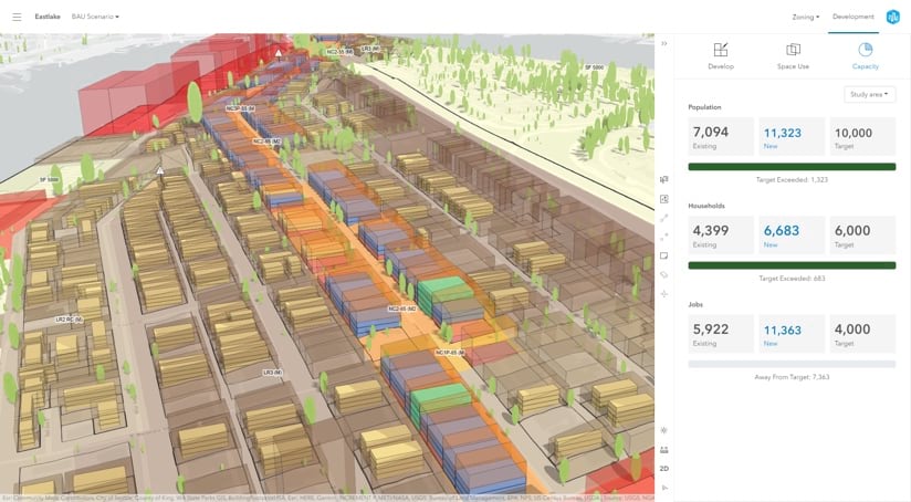
Effective affordable housing relies on sustainable design that is centered around location. The design needs to incorporate transit-oriented design (TOD) in more dense urban neighborhoods in order to increase accessibility to services, education, training and jobs, creating a more walkable and desirable neighborhood. In addition, these affordable housing developments need to blend seamlessly with other existing developments to generate a more cohesive and inclusive neighborhood that meets the needs of all its residents. Creating even one successful affordable housing development helps justify policies to create more affordable housing developments in other neighborhoods, expanding the benefits this housing provides throughout the city. I think there are four key roles for GIS here:
- Empowering planning professionals to design sustainable affordable housing developments.
- Enabling easy comparison of multiple scenarios to help policymakers make better decisions.
- Modernizing zoning ordinances to accommodate new development.
- Providing a platform for citizens and stakeholders to learn about development scenarios and provide feedback.
Economic Mobility
Affordable housing and economic mobility are inherently linked. Economic mobility provides a path for citizens, particularly the disadvantaged, to elevate themselves from stagnant economic conditions. Planners, economic developers, and community leaders have the obligation and ability to design neighborhoods that provide economic opportunities for their citizens. These opportunities, when combined with employers who are incentivized to make long-term investments in personnel, can create jobs and subsequently break cycles of poverty and homelessness. In the bigger picture, this consequently grows municipal revenue, which provides more resources for services. When combined with effective affordable housing, an economic mobility strategy provides pathways for disadvantaged and disenfranchised citizens to capitalize on opportunities and make a tighter connection with their neighborhood. Planners need GIS to:
- Analyze and understand community demographics and socio-economic characteristics
- Assess community needs for employment, training, education, and services
- Monitor and quantify status of economic mobility in neighborhoods
- Coordinate with EDO officials to recruit sustainable new investments and expand existing ones
- Report to policymakers and the public the impact of mobility in neighborhoods
The city of Seattle has been using GIS for years, and recently used some advanced web-based tools to manage their dramatic growth (fastest growth in the U.S. since 2010). They used GIS to inventory housing and employment capacity, gain a growing understanding of changing demographics, and to design affordable housing evenly through its many neighborhoods.
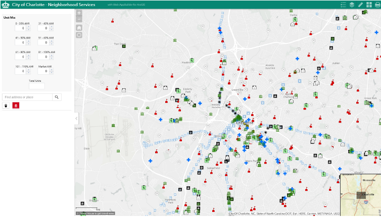
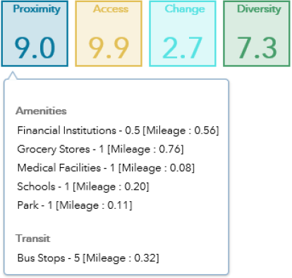
The city of Charlotte took what I believe to be a very repeatable approach to affordable housing. Their Housing Location Policy was designed to distribute affordable housing investments into more affluent communities, in order to limit the concentration of poverty within distressed neighborhoods. They used GIS to create site scoring for proposed locations based on proximity to transit assets and amenities, income diversity, reasonable access to jobs, and level of neighborhood change. The city’s housing operations manager and data analytics team did all of this using web-based tools in ArcGIS.
From increased municipal revenue, to decreased auto traffic, to reduction of poverty, to more diverse and cohesive neighborhoods, effective affordable housing (and an economic mobility strategy) doesn’t just benefit the residents of the housing, but all of a community’s residents.