By Laird Van Dee, GIS/GPS Specialist at Xenia Rural Water District
Xenia Rural Water District is in west central Iowa, and we have an area of a little over 2,500 square miles and around 11,000 customers. We also serve water in bulk to 5 communities, provide water for 14 other communities, and have emergency connections to provide water to 9 other towns if needed. Our whole company is 30 employees: six construction/maintenance personnel, seven water treatment personnel, eight distribution personnel, and nine office staff of various roles.
I am the GIS specialist at Xenia Water. I used GPS early in my career and eventually taught myself GIS. I have worked in rural and municipal water since the early 1990s. I started out installing water mains, operating heavy equipment, and horizontal directional drilling. I worked directly for a rural water utility. I moved from doing installations to customer service calls and Onecall locates for a large rural water utility. My experience with GPS enabled me to complete locates quickly. I learned how to edit points in GIS and manage basic workflows. In 2012 I was given the opportunity to take over the GIS department for the above mentioned water utility. I used DIY resources to teach myself and was a regular caller to the Esri help desk. The GIS staff before me had little in the way of field experience or knowledge of how a distribution system works or should look, so I have been working the bugs out. Around 2014, I started using ArcGIS Online, and over time it became an invaluable tool for many workflows.
Small District, Big Responsibilities
With such a small distribution staff, being efficient is of the utmost importance. Our distribution staff has five staff members that take care of roughly 500 square miles of the territory each, and they average 18 locates and 13 service calls a day. The remaining staff members take care of reading the meters in our system every month. We have to meet the everyday needs of customers with limited resources, while still dealing with the challenges of maintaining a robust and reliable water distribution system. Other challenges like project planning and meeting regulatory requirements have led us to search for better and more efficient solutions. We have even added GPS units to our construction department so it can locate its own lines and collect data on new appurtenances it installs.
Empowering the Workforce
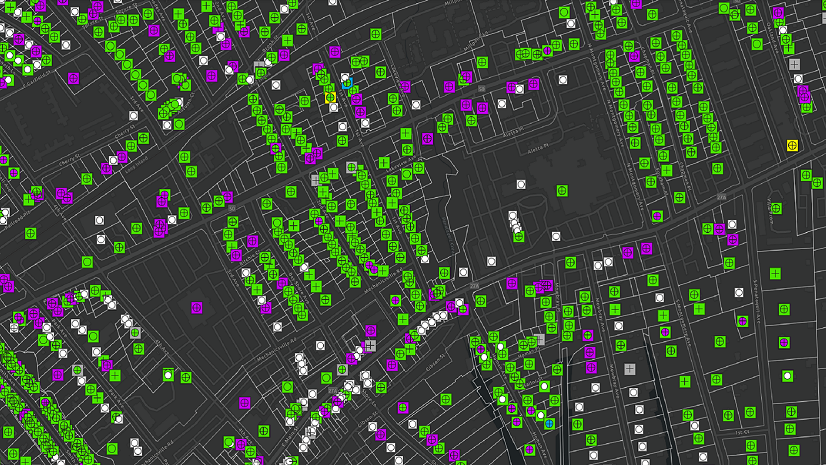
Our distribution staff members use ArcReader and ArcGIS Online for their mapping needs to get measurements for locates or to link directly to our original as-built drawings. Each of our water techs also carries Trimble GPS units with them, a mixture of GEO7X, R8 receivers, and the newer DA2 receivers. The staff uses these to do locates where we have GPS information on the mains, which is most anything installed since 2002, when we started using GPS for our system. These staff members also do data collection on existing and new infrastructure as needed. Our construction/maintenance staff members have Trimble R8 receivers and use ArcGIS Field Maps to collect location for assets that are installed or dug up. Having construction staff shoot their own installations is a huge benefit, since we do not need to send one of our water techs to locate mains or shoot new meter pits or appurtenances that our own crew puts in.
Optimizing Operations Workflows with Mobile Maps and Apps
ArcGIS Online has revolutionized existing workflows at Xenia Water and provided solutions for new challenges as well. Coupled with ArcGIS Field Maps, it has changed how operations and field crews access information, allowing increased confidence, efficiency, and coordination between departments.
Meter Reading
We use ArcGIS Field Maps to track our meters that misread during their regular route reading. We radio read each meter in our system with a truck-mounted drive-by unit. When these fail to read, we have to go manually read them and fix what caused the misread. This used to involve the staff member coming to the office to get the misread list and plot a course of up to 40 sites from a list of account numbers and addresses. Our GIS department realized that it could import the list into ArcMap and post a map to ArcGIS Online. The staff could then use ArcGIS Field Maps to navigate to the meter that had misread, fix the issue, and post the correct reading to the online map, all in real time.

This saved the staff from needing to drive to the office to get the misread list, go get the reading, and drive back to the office with the completed reads. All in all, we saved about $10,000 a year and we sped up our billing by a day for each of our four billing zones. This is significant because if we were short on time, we would be forced to estimate bills on meters we couldn’t get readings on; now, we have an extra day each week to help get readings if there is inclement weather, for example. We also cut our misread rates by 75 percent, partly due to Field Maps being able to scan the meter and Meter Interface Unit barcodes and not relying on the staff to transpose it themselves.
Hydrant Flushing
We also use ArcGIS Field Maps to track our flushing. Due to us being a rural water district, we have a lot of dead-end mains in our system. We try to flush each main once a year. We use a simple field map to track the status of the hydrant, the gallons flushed, and the chlorine levels at the beginning and end of the flushing. This is much better than the Excel spreadsheet we used prior to ArcGIS Online. Using the visuals of the map, we can dispatch staff for preventative flushing when time permits. With a simple glance at the map, we know which areas need to be flushed the most. Prior to this, we would have to use ArcMap to join the data from Excel to create a current map to visualize where we needed to go next. With ArcGIS Online, our staff members also see what needs to be done in the area where they may be doing locates or service calls, saving multiple trips to the same area.
Looking for Lead
The Environmental Protection Agency (EPA) Lead and Copper Rule Revision requires that we perform a service line inventory by October 2024. Because of this, we were looking for a solution to help perform the inventory quickly. Unlike a municipality, Xenia has meters that are set in a pit in the front yard of most homes. We set the pit, and we leave a 5-foot-long stub of PVC pipe on the outlet for the plumber to hook to. Xenia has nothing to do with the line that runs into the house, as it is considered private. This left us at a disadvantage, since the Iowa Department of Natural Resources and EPA specifically wanted to know what was run into the home.

We deployed the Esri Lead Service Line Inventory solution. At the push of a button, we had all we needed to complete a survey of our system. We found inside the solution the ArcGIS Survey123 app, and we took the base survey the solution came with and refined it to fit our situation. We added a few links to items to help customers identify what kind of line they have coming into their dwelling, and we tried to make it as quick and easy as possible to complete the survey and still get quality information. We then crafted a letter that included a link to the survey, and a QR Code that would take a smart device to the survey if scanned. Customers can quickly complete the survey and are even able to include a photo of their service line, which has helped eliminate some questions.

So far, we have sent the survey to two of our billing zones, which make up about 25 percent of all our customers. We have seen about a 45 percent response rate in these first two zones. This is huge. Since we have limited staff to do in-home surveys, having customers complete the simple online survey gets us much closer to completion.
The Lead Service Line Inventory solution from Esri has placed Xenia in a great position for completing the EPA required inventory by October 2024.
Small Staff, Large Value
Our GIS capabilities are getting stronger every day. We continue to find new ways to integrate Esri solutions and products into our daily work routines. Every day we find added value in the solutions and products. Xenia’s ability to provide safe clean drinking water to rural areas and small communities is thanks in part to our mapping and GIS systems making our small staff feel so much larger.
Stay Connected with Esri’s Water Team
ArcGIS is an extensive information system that enables modernization of workflows with easy-to-use applications for the field and office. Strengthen your organization with smart water solutions that will increase efficiency and provide insight for decision-makers. Visit the Esri Water Utilities web site for more information.
Join the Water Utilities Community
Follow #EsriWater on social media: Twitter | LinkedIn
Subscribe to the Water Industry newsletter “Esri News for Water Utilities and Water Resources“
Learn more about how Esri supports rural and small water.
About the author