We have outlined the case for launching a substantial infrastructure investment program, both from an economic recovery perspective and for laying the foundation for growth over the coming decades. We have argued not only for traditional investment in infrastructure but also for transforming our rural areas with targeted investment and discussed the necessity of making considerable investments in the transportation technologies of the future to help the US regain its technological leadership in the world economy. In this final segment in the series, we address how we can best analyze the performance of our current infrastructure management and determine where to make the most strategic investments to achieve these goals.
Understanding Our Infrastructure
Good asset management and preservation practice depends on knowing the location and condition of your assets. The same holds true with understanding where we need to restore and maintain our existing infrastructure and where we need to make new investments. And that is where geographic information system (GIS) technology is uniquely suited to help our cities, counties, states, and federal government determine where restorative maintenance is needed.
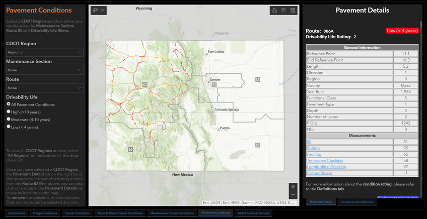
Currently almost all state Departments of Transportation capture their basic asset inventories using Esri technology, and most link to some type of formalized asset management solution. Much of this data, in turn, is submitted annually to the Federal Highway Administration, where Esri technology again can play a key role in bringing these disparate submittals into an integrated whole. So we already have a good information foundation to understand the location and condition of the vast majority of our transportation infrastructure—not just from highways but across most modes. And this data establishes a baseline and foundation for our analysis.
Understanding Performance and Bottlenecks
The next step is understanding the current performance of our transportation systems, determining where we have deficiencies and bottlenecks and where we need to make new investments. GIS links to a wide range of travel-demand forecasting models to help us understand future demand for the next 20 or 30 years, and to other datasets that provide information on current levels of congestion, changing mobility patterns, and our current freight and multimodal flows. This is where we need to take not only a national view but a more comprehensive, state- and local-level view of where investments are needed.
A national-level view of our transportation networks would help us discern where investments would significantly improve goods movement and make national supply chains more efficient. In many cases, these investments would be advantageous to entire regions but cannot be supported by a single state’s investment budget.
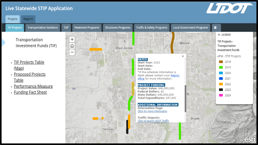
A key feature of GIS is the ability to integrate information from many different sources to give transportation agencies a more comprehensive view of their infrastructure and the performance of their networks.
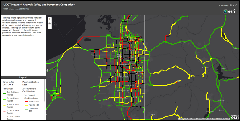
Transportation planners need to bring together information about the condition of their current infrastructure along with safety and congestion data, among others, to help make the best decisions.
Analysis and Prioritization
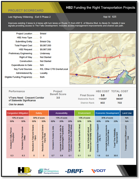
Making the most strategic investments almost always involves finding the optimal balance between different values—whether safety concerns, congestion mitigation, or economic development considerations—to achieve the greatest societal benefit. Analysis supported by GIS can help us understand the trade-offs between different investments, ensuring that we target dollars to deliver the greatest impact. As such, GIS is a platform of insight that helps agencies make smarter investments in the future of American infrastructure.
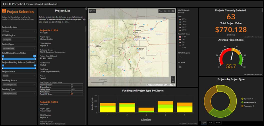
The analytical tools in ArcGIS are perfectly suited to this type of trade-off and prioritization analysis. The goal is to ensure the right project, at the right time, at the right cost. Whether alone or in combination with other tools and models, GIS can help visualize and analyze a number of competing alternatives to ensure the most strategic decision.
Collaboration and Communication
Effective infrastructure planning ultimately requires considerable coordination not only within but across agencies as well. This ensures that all parties can coordinate and collaborate on the development of shared goals, objectives, performance measures, and targets.
GIS technology provides a framework to facilitate data sharing and collaboration within or between agencies. The various agencies can all share the same information and have the same understanding with respect to project definitions. In addition, they can collaborate on analyses, modeling, and other project alternatives and share results, leading to a comprehensive and cohesive planning framework.
As a result, GIS can provide a common platform, allowing Congress, the administration, and the various state Departments of Transportation to share an understanding of the current condition of our nation’s assets, where the needs are greatest, and how we can identify the most strategic infrastructure investments to deliver the greatest benefit.
Additionally, GIS provides an effective way to monitor the progress and performance of those investments and to communicate the benefits to a larger public audience in an easy-to-understand fashion.
We have argued for a bold and visionary plan for restoring America’s economic competitiveness by making critical infrastructural investments. We believe that GIS technology can be an integral component of the overall strategy by creating a collaborative framework, which can help agencies make strategic decisions and monitor the performance of those investments to demonstrate the value of the overall initiative. Using GIS technology to communicate the status and progress of these investments can not only serve to build greater support but also provide greater transparency and accountability to the public—leading to a brighter economic future with benefits more widely shared.