For many, high school can be a time that helps define our future. For Cameron Levine, high school played a crucial role in outlining his future academic career path in geographic information system (GIS) technology. He was introduced to GIS by his human geography high school teacher, who would later influence him to pursue a geospatial path as an undergraduate.
“GIS was incorporated in my high school AP Human Geography course because my teacher used to be a GIS analyst. Through that, I was inspired to pursue GIS in college and decided to go through the geodesign undergraduate program,” says Levine.
Beginning a Geospatial Academic Journey
Exposure to GIS in secondary schooling influenced Levine to pursue a geodesign undergraduate program at the University of Southern California (USC). Through this program, he had the opportunity to work on various projects involving GIS such as data collection and mapping analysis. This geodesign program ultimately led him to expand his knowledge of GIS by learning and applying R-ArcGIS Bridge and ArcGIS Pro in a spatial statistics course where he was mentored by Dr. Orhun Aydin, current senior researcher and product engineer at Esri and adjunct professor at USC. Aydin advised Levine in his senior research project Presence Only Modeling of Fallowing in Europe with Maximum Entropy.
Cameron has been working on statistical models applied to spatial data with me and has been developing methodologies in R for field detection in precision agriculture problems. Cameron has been using R-ArcGIS Bridge and ArcGIS Pro heavily in his work.
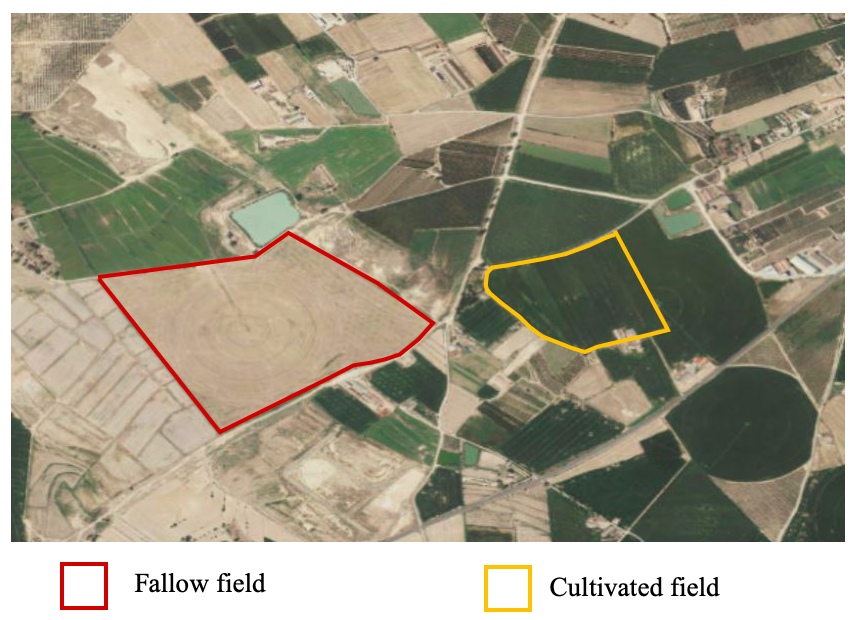
Using R-ArcGIS Bridge to Analyze Land Fallowing
Levine’s senior project consisted of creating a statistical model for land fallowing in Europe. Land fallowing is a land management technique where a farmer will leave a plot of land uncultivated for a season (or more) to increase soil moisture, prevent erosion, assist in pest control, and many other reasons.
“As population growth increases the demand for farmers to produce, they are pressured to decrease the length of the fallow period. While shortening the fallow period can help meet immediate food production needs, it has negative consequences for agroecosystems,” explains Levine. “This project was a starting point to map where fallow fields might be. Future iterations of this model could be used to see the connection between temporal trends in land fallowing, climate change, and food insecurity.”
His project sought to identify fallow fields by using remote sensing data and soil quality data. He used a species distribution model called MaxEnt from R’s maxnet package to create a map showing the probability of fallow field presence.
“For this project, I used R-ArcGIS Bridge with ArcGIS Pro, and having that bridge between both types of software tools was really helpful,” Levine states.
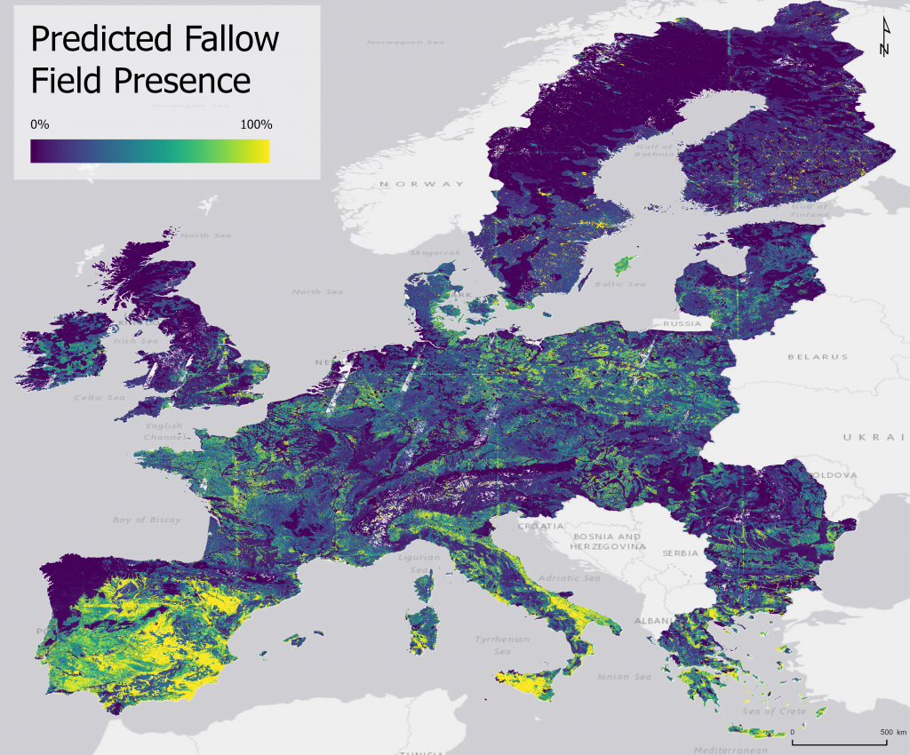
He used R and ArcGIS Pro to extract remotely sensed values at the locations of fallow fields and take that dataset and use R-ArcGIS Bridge to create the MaxEnt model. The result is then visualized on the map in ArcGIS Pro and rendered using the ArcGIS Pro advanced rendering capability. The results of his mapping and analysis identified subregions of Europe where he saw large clustering of pixels with a high probability of fallow presence.
The challenges Levine faced in this project were wrangling with data and working with large satellite imagery datasets. Having a good implementation that integrates ArcGIS Pro and R was an asset in overcoming some of these hurdles.
“The R-ArcGIS Bridge enabled me to directly bring in data from ArcGIS Pro into an R notebook. This bridge streamlined what would otherwise be a cumbersome process,” says Levine.
In addition, having a faculty advisor like Aydin, who specializes in R-ArcGIS Bridge, would be instrumental in overcoming some of those obstacles.
“It was great to have someone like Orhun to help me with this project. His help played a crucial role in the trajectory of my research,” says Levine.
Discovery Scholar Awardee
Levine’s work led to a Discovery Scholar Award, given to students who have made an influential impact and have gone above and beyond in their field of study. Levine received the award for the field of spatial sciences at USC’s commencement for his work analyzing land fallowing in Europe.
“I thought this project would be a great fit for an example of how I can advance spatial sciences in some way. I wrote a report and submitted the deliverables and was pleasantly surprised that they chose my project,” Levine states.
Levine’s project not only won the Discovery Scholar Award, but it also earned the Best Use of Technology Award at the 2021 Los Angeles Geospatial Summit. Students, educators, and professionals come together at this annual summit for technical workshops, poster competitions, networking opportunities, and more.

New Windows of Opportunities
Levine’s geospatial academic journey and senior research project on land fallowing led to an incredible summer internship opportunity. In summer 2021, Levine will be working with the National Aeronautics and Space Administration’s (NASA) DEVELOP program on a remote sensing internship using remote sensing data to create benchmarks of the growing seasons for farmers in Iowa. This study will help farmers determine if they should plant and harvest earlier.
“My team is creating an interactive tool for Midwestern farmers to see the feasibility of diversifying the species of crops they plant. We’ll be using remotely sensed data, along with platforms such as ArcGIS Pro and ArcGIS Online, to create our final outputs,” Levine explains.
Looking to the Future
Levine shared his interest in exploring the model of land fallows for the entire US. He also expressed the hope of exploring this in areas that experience greater food insecurity, such as Eastern Africa; South America; or Nepal, India.
“Europe was a great initial study site because of the availability of ground truth data. The European Commission’s Eurostat provides the validated data collected from people surveying the land,” says Levine.
Levine hopes to continue the project in the future and make it repeatable for others to carry out the same workflow for different locations such as in the United States.
“We hope other researchers will be able to recreate this model and workflow with a different dataset. It would be exciting if the results of my study could help inform a FAO report in the future,” Levine states.
Thanks in part to the geospatial skills Levine gained while in pursuit of a geodesign undergraduate degree and the success of his research project on land fallowing, he is now able to apply GIS in future internships and careers. When asked if he would share advice for other students, he states, “It’s important to seek out what interests you. Even if the opportunities do not appear available, you can apply GIS to your area of interest, and it can lead to a very rewarding experience.”
The strength of GIS is its flexibility to meet the users’ needs and communicate with your audience.
Read another example of a successful application of students in higher education using GIS.