The Port of Corpus Christi is often hailed as the energy port of the Americas. To understand its intricate infrastructure and operations, we embarked on an ambitious project to create a digital twin of the port. We sought to integrate diverse geospatial data and imagery to forge a comprehensive 3D map and analyze the port’s sprawling infrastructure and bustling operations. This venture was not just a test of technical prowess but a deep dive into the potential of geographic information system (GIS) technology in modern port management and security to deepen our understanding and contribute to enhanced decision-making.
The first step involved gathering electronic nautical charts from the National Oceanic and Atmospheric Administration (NOAA) to accurately depict maritime pathways. Historical Automatic Identification System (AIS) data was crucial as it shed light on vessel movements, providing us with patterns and operational dynamics of the port. However, the real challenge lay in digitizing the port’s facility guide and amalgamating this information with high-resolution images from Maxar and BlackSky satellites. This effort was pivotal in refining our coverage and understanding of the port’s layout and activity zones.
The integration of pretrained deep learning models marked a significant leap in our project. Using Meta’s Segment Anything model, bolstered with generative AI in ArcGIS Pro, we could swiftly extract critical features such as roads, buildings, and tank locations. This technological leap not only accelerated our progress but also enhanced the accuracy and depth of our analysis.
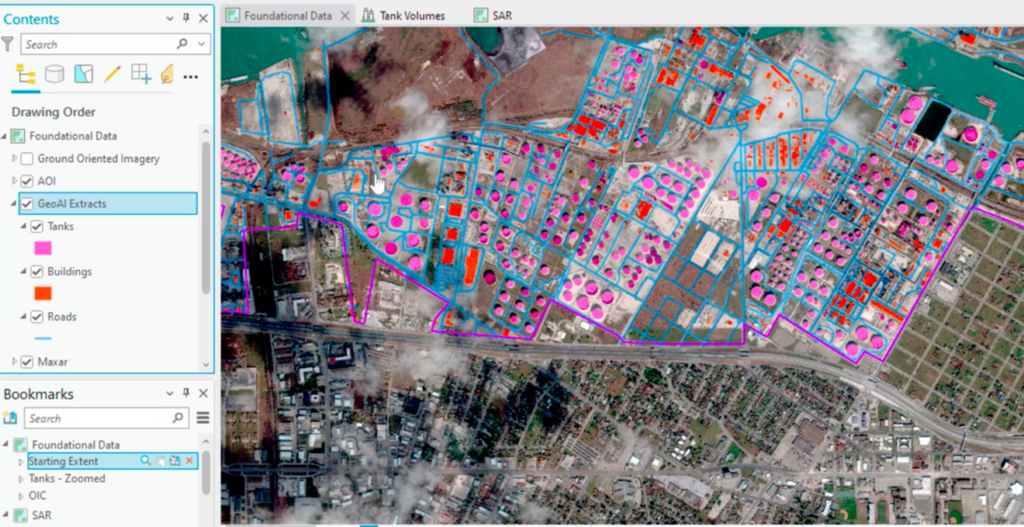
Roads, Fuel Tanks, and Buildings Extracted Using Pretrained Deep Learning Models
Drone missions added another layer to our data collection, supplementing satellite imagery with even better high-resolution data of key port areas. The introduction of the ArcGIS Video Server capability was a game changer, enabling us to stream video layers from a variety of sources, including drones, satellites, security cameras, and mobile devices. This feature allowed us to monitor the port’s operations in real time, offering a dynamic view that static images could never capture.
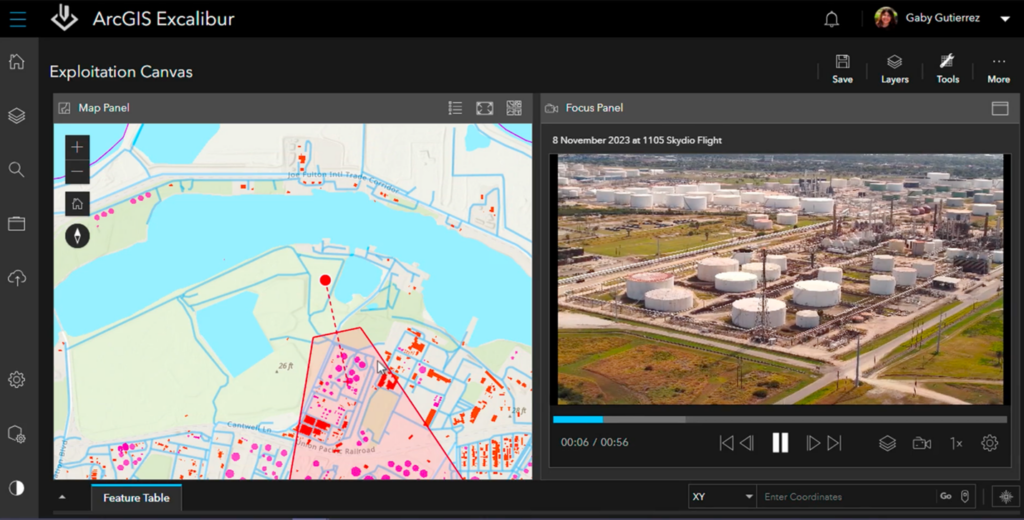
Drone footage of the port can be explored in ArcGIS Video Server. The location of the drone and the image footprint are shown on the left.
Utilizing oriented imagery layers within the ArcGIS platform, we integrated images from diverse sensors, which provided unique insights into the port’s operations. These can be images from a phone; oblique images from a drone; or images from other types of sensors like the thermal image below of a fixed-roof tank.
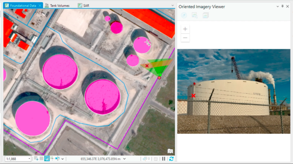
Oriented Images Captured on a Phone, with Their Location and Orientation Shown on the Left
One of the most intriguing aspects of our analysis involved using thermal images to measure the content levels in fuel tanks. Observing the top of the liquid in the tank shown below, we estimate the tank to be 70 percent full. This approach demonstrated the versatility and breadth of GIS technology in operational management and strategic planning.

Thermal Image of a Fuel Tank
Our oriented imagery also showed vehicles parked in rows at the port. However, when our drones flew over the same area and we processed the images using ArcGIS Reality, no vehicles were visible. We decided to better monitor the movement of assets in this area. We tasked satellites from Capella Space, which collected synthetic aperture radar (SAR) imagery. SAR technology’s ability to detect movements, operate under any weather conditions, and penetrate cloud cover enabled us to comprehensively monitor ship activity and the port’s operational dynamics.
Using the tools in ArcGIS Pro, we can prepare our SAR data for analysis. We see differences when comparing an optical image, collected on a clear day, with a SAR image collected on the same day. As we continued our collection over the next few days, clouds obscured our view of the parking lot. SAR technology allowed us to continue to monitor the area while the weather persisted. SAR imagery from a few days later showed an increased number of vehicles within that lot. Using a custom raster function, we compare what we see on one day with what we see four days later. The results show us the earlier day in yellow and the latter day in blue, allowing us to detect the changes from one image to another immediately.

SAR image showing data from two different days overlaid.
Using a variety of imagery sources, we gained a deeper understanding of the other assets in this area. Whether it’s to monitor compliance with safety regulations or detect illegal fishing activity, SAR capabilities within ArcGIS can improve maritime situational awareness. SAR data offered a reliable stream of information that was crucial for our continuous analysis, especially in understanding the port’s 24-hour operations under various environmental conditions. Combining the SAR data with AIS data, we were able to detect and verify shipping activity regardless of clouds or time of day.
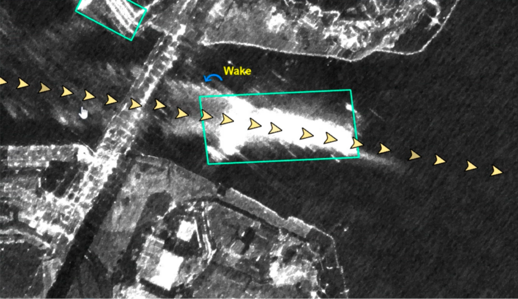
A ship and its wake are depicted with SAR and AIS data.
The culmination of our project was the creation of ArcGIS StoryMaps briefings. These slide-based presentations consolidated our findings and showcased our project’s success in creating a digital twin of the Port of Corpus Christi. More importantly, ArcGIS StoryMaps briefings highlighted the vast potential of GIS technology in crafting detailed digital representations and analyses of critical infrastructure.

Corpus Christi is shown in ArcGIS StoryMaps briefings.
Reflecting on this project, the journey was as significant as the destination. We succeeded in developing a detailed digital twin of one of the United States’ most critical energy ports and demonstrated how GIS technology could be leveraged to gain insights beyond conventional analysis. This venture into creating a digital twin of the Port of Corpus Christi serves as a beacon to others, illuminating the path for future projects aiming to understand and manage complex facilities around the globe.
The integration of various data sources, the application of deep learning and AI, and the innovative use of SAR imagery and oriented imagery layers were key to our success. With these technologies, we were able to better understand the complexities of the port’s operations and infrastructure and offer a detailed and dynamic analysis that was both comprehensive and insightful.
The Port of Corpus Christi’s digital twin is not just a model that can be applied to other ports and facilities around the world; it’s a testament to the capabilities of modern GIS technology in planning, management, and security. It reminds us of how far technology has come and how much further we can go in our quest to understand and manage the complexities of our world. ArcGIS transforms how we see and interact with the world around us.
