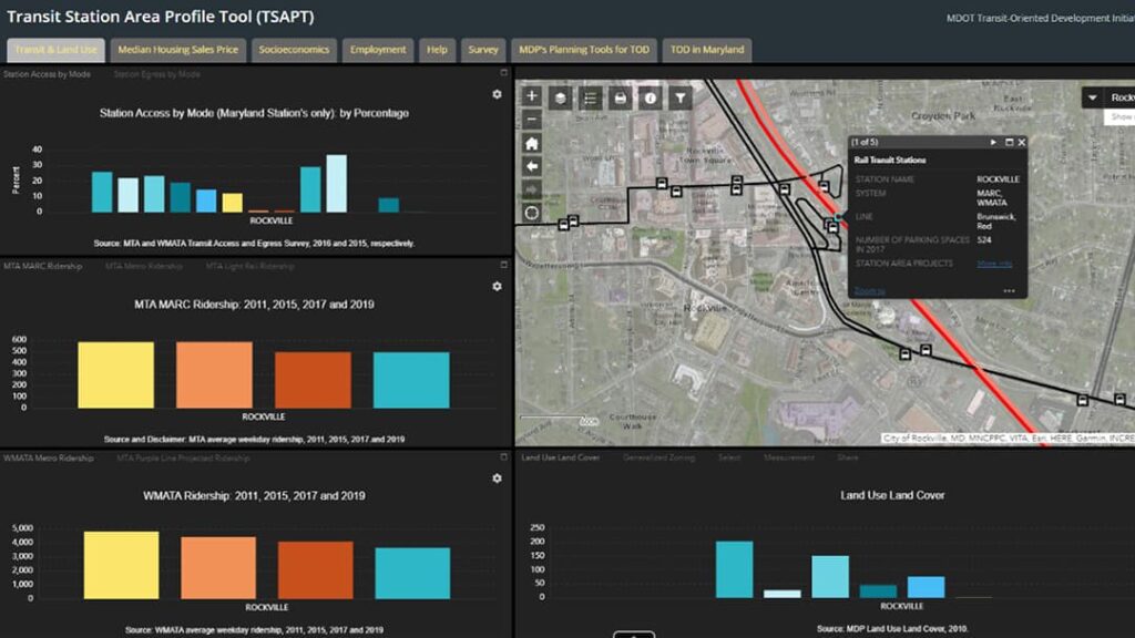
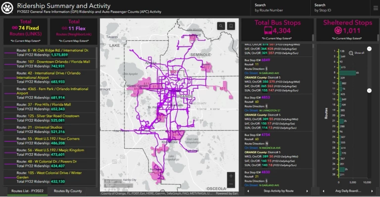
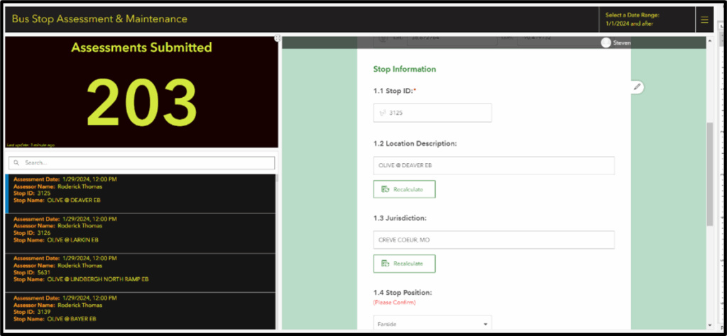
5 FAQs on GIS for Public Transit
Public transit is undergoing a transformation. Agencies are rethinking how they plan, operate, and serve their communities in a world where expectations are higher and resources are tighter. At the center of this shift is the growing recognition that location is not just a data point; it is everything.
To explore how transit organizations can implement location intelligence across their enterprise, we turned to Anika-Aduesa Smart, a respected voice in the industry with more than 20 years of experience in the public transportation sector. Now serving as director of transit at Esri, Anika brings a unique perspective to how enterprise geographic information system (GIS) technology can unify transit organizations, drive measurable outcomes, and empower agencies to make location the foundation of their strategy.
In this Q&A, she shares insights on how GIS is transforming planning, operations, maintenance, safety, and customer experience, helping agencies move from reactive problem-solving to proactive, data-driven leadership.
Q: Why is location intelligence essential to the future of public transit?
A: Location is built into everything that transit does. Location intelligence is essential to transit today . It’s what allows us to optimize our routes, improve service delivery, and really enhance the customer experience. By digging into the “where” of our transit data, we can spot patterns across an agency’s business workflows that we likely didn’t—and couldn’t—see before. That’s the beauty of location analytics. We can assess and make better-informed decisions about where to allocate resources effectively and efficiently. Ultimately, making public transit more attractive and accessible is key to increasing transit’s role as a vehicle for economic mobility, and location intelligence is at the heart of that journey.
Q: How does GIS elevate transit-oriented planning from reactive to visionary?
A: In transit’s world, GIS really takes planning to the next level. It gives us this comprehensive, big-picture framework to analyze spatial data, which means we can anticipate future needs instead of just reacting to the issues at hand. By integrating demographic and economic trends, traffic patterns, and land use, GIS allows us to visualize different scenarios and strategies to connect communities with each other. This kind of foresight is invaluable for designing transit systems that align with community growth and development goals, fostering sustainable and resilient urban environments. It’s how transit stays ahead of the mobility curve.
Q: What operational efficiencies can GIS unlock for transit agencies?
A: GIS helps us optimize routes, allocate resources better, and monitor service performance in real time. By analyzing travel patterns and ridership data, we can design routes that reduce travel times and costs for our riders and take them where they want to go. With real-time data integration, we can respond quickly to service disruptions, enhancing reliability and boosting customer satisfaction. All these efficiencies create a transit system that’s not just more responsive, but also more resilient.
Q: How does GIS support smarter and more sustainable asset maintenance strategies?
A: GIS does more than locate assets on a map; we can analyze asset wear patterns, and even assess the environmental impacts on them, which leads to smarter resource management if you have a clear picture of the challenges. It can help maintenance teams engage in predictive maintenance, using historical data to foresee potential issues before they escalate. This proactive approach not only extends the lifespan of our assets but also optimizes already limited resources and supports keeping assets in a state of good repair.
Q: In what ways does GIS enhance the customer experience across the transit journey?
A: There is so much untapped potential here! Of course, there is no other system better at integrating spatiotemporal data for real-time wayfinding, giving passengers live updates on schedules, delays, and service disruptions—which helps them make informed decisions on the fly about their journey. With GeoAI, and our new offerings, we have the chance to make transit a service for everyone, no matter what language they speak or how they speak it. Analyzing a system’s accessibility with GIS ensures routes and stops are convenient for everyone, including those with disabilities. Insights gained from GIS can point to opportunities for on-demand options for first/last-mile travel. These enhancements contribute to a more enjoyable transit experience for all customers.
The Road Ahead
Looking ahead, the future is incredibly promising for GIS in transit. As a forever transit professional and advocate, I know we have an opportunity here to think outside the box and explore innovative applications of GIS that go beyond traditional uses. It’s important we break down the silos within our organizations and connect them through technology, rather than create new barriers with technology. With Esri’s enterprise approach, we can integrate GIS seamlessly into our daily operations. Plus, our transit teams have more time and resources to make better decisions to deliver world-class service because they are embracing the mantra of “good data, better technology, best practices.”
Additional Content You’ll Love
- 10 Powerful Things You Can Do with Transit Data in ArcGIS
- Get on board the Esri Transit Initiative
- Data Driven Transit: Unlocking real-time insights with ArcGIS Velocity
Stay in Touch
Be in the know! Join our monthly eBrief for fresh updates and stories on GIS in Public Transit.


![Hello [Transit] World!](https://www.esri.com/en-us/industries/blog/app/uploads/2026/01/googleshareimage_helloworld.png)