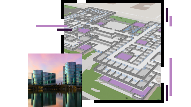
Skip to Content

Facility and Workplace Management

Optimizing facilities and promoting high performance with GIS

A 3D indoor model of an office complex overlaid with a photo of modern mirrored skyscrapers reflecting a pink and orange sunset sky

Creating the ultimate workplace experience

For competitive technology companies, it's not enough for facilities optimization to focus solely on maintaining assets. Forward-looking leaders can holistically manage facilities with a geographic information system (GIS) to ensure efficient operations—from understanding real estate demands and infrastructure needs to optimizing spaces in offices and data centers. Gain a dynamic view of facilities, with perspectives from global to hyperlocal, to make proactive decisions that keep facilities running at full potential and retain top talent.

Previous
Next

Deliver excellent workplace services

Streamline workplace & facilities management

Use smart maps and dashboards to enhance day-to-day operations and maintenance status with real-time awareness of fixed and moving asset locations and conditions. Speed data sharing with mobile apps that support streamlined communication and quick resolution of issues. Understand the best ways to deploy resources for top performance while managing costs.

A map dashboard with an indoor map of an office complex and several graphs and lists of data

Optimize space management

Properly define, allocate, and assign space to better support workplace productivity with GIS. Optimize team access to building assets including collaboration spaces, conference rooms, equipment, and amenities. Minimize wasted space and foster essential connections among staff.

An indoor map of an office building alongside a menu of analysis options

Strengthen site safety

Give business leaders, security managers, and operations teams the real-time situational awareness and advanced geospatial analytics they need to minimize risk and provide secure workplaces. Dynamic maps deliver a common operating picture for planning and response activities to protect people, property, and business continuity.

A map dashboard with an indoor office map and several data points

Enhance portfolio management

Elevate traditional market knowledge with powerful spatial analysis tools to optimize facilities selection and planning. Unite disparate data streams into a single view to visualize demand and opportunities at all scales. Use dynamic smart maps to understand the environment around and within sites and facilities, energy costs, and infrastructure. Determine where to best allocate strategic investments based on real-world conditions grounded in location-specific data and analysis.

A world map in dark gray and blue witA 3D model of a city filled with dark gray skyscrapers, with one proposed skyscraper fitted in the center shaded orangeh scattered brightly lit multicolored map points

WHERENEXT

Exploring a breakthrough in real-time mapping

An innovation in real-time mapping improves workplace safety in warehouses, on work sites—even on the ski slopes.

Read the article

Products

Previous
Next

Contact sales