ArcWatch: GIS News, Views, and Insights
October 2012
Visualizing Bathymetric Data Using the Esri Ocean Basemap
By Jack Hunt
Esri Maritime Team
The excitement surrounding the exploration of Mars by the National Aeronautics and Space Administration (NASA) rover Curiosity exemplifies our inquisitive human nature. However, some of the greatest mysteries lie closer to home in the world's vast oceans.
The new Ocean Basemap, rich in detail, helps marine GIS professionals in their work and research. The basemap receives bathymetric data from organizations such as the National Geophysical Data Center (NGDC) at the National Oceanic and Atmospheric Administration (NOAA). NGDC's data contributions have turned the Ocean Basemap into a comprehensive and informative geospatial reference tool. Read the article.
Esri hosts the Ocean Basemap in ArcGIS Online. Read this article to delve more deeply into what the basemap provides and learn how to get started using it as a cartographic reference or a foundation to build your own maps.

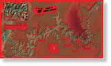
The Ocean Basemap is displayed in the National Oceanic and Atmospheric Administration's Bathymetry Data Viewer, with multibeam bathymetry surveys applied.
Tip of the Month
Clip the Data Frame to Make Your Map Polished and Professional
Make the most of the real estate on your page! Use clipped data frames to show maps in shapes that you create to fit the available space. Read this tip.
Connect with ArcWatch
ArcWatch is published monthly by Esri and contains GIS news, practical advice, and updates about the company's software and events. To submit article ideas, e-mail editor Carla Wheeler at arcwatch_editor@esri.com.
Join the Conversation
Analyzing Swing States
Demographics will play a big role in this year's presidential race between president Barack Obama and former Massachusetts governor Mitt Romney. Knowing where to find the voters that support each candidate will be critical in driving voter turnout—and determining who wins or loses the presidency. GIS technology such as Esri Business Analyst for Desktop and Esri data can help campaigns zero in better on their constituencies to decide where to generate "robocalls," raise funds, and get out the vote. Read the article.
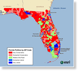
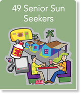
Targeting Senior Voters
How can political campaigns and candidates identify, understand, and reach different groups of senior citizens and spur them to donate, volunteer, and vote? They can use Esri's Tapestry Segmentation to study the demographics and lifestyles of seniors in the United States. The segmentation data classifies seniors into nine lifestyle segments, including Senior Sun Seekers, Prosperous Empty Nesters, and Rustbelt Retirees. Read the article.
GIS Flourishes at Stanford University
Students at Stanford University in California take advantage of the school's GIS lab, using geospatial technology to work on their academic projects. For example, students have used GIS to conduct historical research on slaughterhouses and meat production in urban areas in the nineteenth century and on prostitution arrests in Philadelphia in the early twentieth century. Read the article.
Transform Your Organization
The free nationwide seminar ArcGIS 10.1: Transform Your Organization continues through November 2012 in cities across the United States. Register to attend and learn how ArcGIS 10.1 will make it easy to establish a mapping platform for your organization so you can share geographic information more widely.
Bathymetric Data Made Easy
ArcGIS for Maritime: Bathymetry makes working with bathymetric data less complex. You can use it to help create surface models for chart production, offshore geological analysis, pipeline planning, tsunami assessment, environmental and fisheries management, oil platform siting studies, dredging operations, and more. Watch this recorded webinar to learn more about ArcGIS for Maritime: Bathymetry. Get a free 60-day trial, too.
The Future of ArcGIS
ArcGIS program manager Jim McKinney and his team talk about what they are working on to improve the technology and what's coming next, including new geospatial analysis tools, faster 3D rendering, and support for the Apple Macintosh operating system. Watch the video.
How a Florida City Uses ArcGIS for Local Government
Ian Wint, GIS manager for the City of Fort Lauderdale, Florida, talks about how his municipality uses ArcGIS for Local Government to build mapping applications for citizens. An example is the City of Fort Lauderdale Park and Recreation Finder. Watch the video.
The Content Portfolio in ArcGIS Online
Deane Kensok and Sarah Osborne from Esri explain what type of geographic content and capabilities are available using ArcGIS Online and demonstrate how to use them. Watch the video.
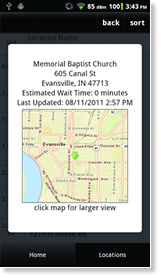
Mapping the Vote Centers
To make getting to the polls easier on Election Day, Vanderburgh County, Indiana, offers a free mobile mapping application built with Esri technology that provides details on the nearest vote centers, including poll hours, wait times, and directions. Read the article.
White Paper: Revealing the 'Where' of Business Intelligence Using Location Analytics
New Version of ArcGIS for Windows Mobile Released
Free Trial of Esri Maps for Office
County Goes to the Cloud
Sussex County, New Jersey, uses ArcGIS Online to share dynamic maps, including the locations of polling places and the latest bridge and road closures. "ArcGIS Online provides us with an easy-to-use way to distribute our data to the public," says David Kunz, the county's GIS manager. Read the article.
Learn about Map Algebra
C. Dana Tomlin's GIS and Cartographic Modeling explores map algebra, a system of mathematical operations and analytical functions used within a GIS to combine existing map layers (rasters) to create new ones. This is an idea Tomlin developed in the early 1980s. Recently republished by Esri Press, this book includes a new preface and illustrations. Buy the book.
Newsroom
Mapping Grand Canyon Deaths
Find out how Esri created the print and web versions of the Death in Grand Canyon map, which illustrates the locations of where 770 people have died since 1869. The creation of the map was inspired by and based on the book, Over the Edge: Death in Grand Canyon. The print version of the map was showcased at the Esri International User Conference, where people used ChromaDepth 3D glasses to view it. Read the article.
ArcGIS Online Adds CityEngine Web Viewer
Sharing your 3D content just got easier with the addition of CityEngine Web Viewer in the new release of ArcGIS Online. Get the details in this blog post from Esri's Bern Szukalski.
Generating Distributive Flow Maps with ArcGIS
You can use flow maps to show how goods or people move from one place to another. A tool called the Flow Map Generator, available on ArcGIS Online, will help you generate distributive flow maps. Read the blog.
Esri Developer Summit Is Coming to Europe
Meet the people responsible for developing Esri technology and take technical sessions on how to develop your own applications using GIS at the Esri Developer Summit in Europe. Events will be held in Rotterdam, London, Madrid, and Berlin in November 2012. Register now.
Send in Your Paper Abstracts for the Esri UC!
Do you want to give a paper presentation at the Esri International User Conference (Esri UC) in 2013? Submit your abstract by October 26, 2012.
Esri Technical Certification: New Payment Options Available
In response to requests from users, you can now pay for Esri Technical Certification exams directly through Esri. Learn more.
Download the Squad Leader Application Template
Podcast: "How to Migrate from a Single to a Multiuser Geodatabase"
Create a Dynamic Table in Your Map Layout
Esri Insider
Happy Fiftieth Anniversary, GIS!
This year is the fiftieth anniversary of GIS. Who and what spurred the invention of this revolutionary technology? Read this blog post by David DiBiase, Esri's director of education.Mapping Extreme Temperatures with GIS
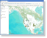 Have you ever looked at the weather page in the newspaper or online and wanted to map the day's extreme temperatures in your country or around the world? It's possible using ArcGIS Online, says Esri education manager Joseph Kerski. GIS can help you discover, for example, what influence seasons, latitude, altitude, and proximity to oceans have on the location and pattern of extreme temperatures. Read the blog.
What You Need for GIS Day
GIS Day salutes geospatial technology and its power to transform and improve people's lives. This year's celebration will be November 14, 2012. Many new resources were recently added to GISDay.com to help you plan and host a great event. Read the article.
Send In Your Maps
The clock is ticking toward the November 16, 2012, deadline for submitting your maps for Esri Map Book, Volume 28. Use the online submission portal. If Esri selects your map, it will be published in the book, which will be distributed at next summer's Esri International User Conference.
Watch Two Live Training Seminars
Tune in to see the free live training seminars Creating Hosted Map Services on ArcGIS Online on October 25, 2012, and Working with Scientific Data in ArcGIS on November 15, 2012. You can ask questions via e-mail of the presenters after the seminars. Learn more and subscribe to receive reminders.
Public Works and the Cloud
Esri public works industry manager David Totman discusses the potential benefits of a cloud-based GIS solution for departments that currently use paper-based mapping services. Join the discussion at the Spatial Roundtable.
A Global Cartographic Resource
In this podcast, Mani Singh, president of mapsofworld.com, talks about using ArcGIS to create and serve high-quality maps of every part of the world.
Check Out the New Esri Maps for IBM Cognos Resource Center
Hardware Offers
Technical Talk

Web Resources and More
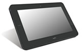 Esri offers US customers two new packages that include a Motion Computing CL910 Rugged IP52 Tablet PC. These devices are lightweight and are built for mobile workers on the go. They come either packaged with ArcPad or intended for use with ArcGIS for Windows Mobile. Learn more about all Esri and Motion Computing offers.
Visit the Esri Store to find more software and extensions, upgrades, data, books, and hardware bundles.