ArcWatch: GIS News, Views, and Insights
November 2012
Bug Wars
By Mike Schwartz
Esri Writer
With the motto "Map, Track, and Attack," a suite of Esri-based software applications called Sentinel GIS is helping the San Joaquin County Mosquito and Vector Control District in California's Central Valley better manage mosquito control treatment, surveillance, and work orders.
Mosquito-borne diseases pose a major health hazard worldwide, including in the United States. The Centers for Disease Control and Prevention reports that the number of cases of West Nile virus exceeds 5,000 so far this year for people in the United States.
The district's mosquito control technicians use GIS in many ways, including to monitor the locations of mosquito populations and to keep track of where they use pesticides. The software also warns the workers about what areas to avoid, such as organic farms and beehives.
And when they return to the office, they can transfer the mosquito surveillance and treatment data that's on their mobile device into GIS desktop software. Read the article.

GIS helps manage many aspects of the work that's done to control mosquitoes, which carry many deadly diseases.
Tip of the Month
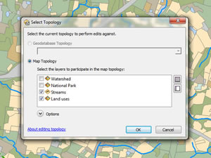
Learn How to Create a Map Topology in ArcGIS 10.1
When editing map data, you often will have features that share boundaries. Editing with topology can reduce the chance of introducing inadvertent gaps or overlaps between features that share geometry. Read this tip.
Connect with ArcWatch
ArcWatch is published monthly by Esri and contains GIS news, practical advice, and updates about the company's software and events. To submit article ideas, e-mail editor Carla Wheeler at arcwatch_editor@esri.com.
Join the Conversation
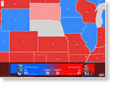
Map the Vote
View the 2012 election results using a map powered by Esri that contains results from the Associated Press. Use this detailed map created by the Stanford Spatial Social Science Lab to drill down to the precinct level and get a bird's-eye view of where President Barack Obama and challenger Senator John McCain won the most votes in 2008.
Try Your Hand at Geodesign
Join the best and the brightest minds in geodesign at the 2013 Geodesign Summit in Redlands, California this January. For the first time, you will be able to sign up for 90-minute workshops, where you will get to work with geospatial technology as you analyze and inform your designs. Read the article.
Plan and Monitor Map Caches in ArcGIS 10.1
New features in ArcGIS 10.1 make it easier to estimate map cache sizes and track the cache's progress as the tiles are being built. Read the article.
What Is Geoliteracy?
True literacy—about words, numbers, graphics, personal finance, and social relationships—means more than simply memorizing and then reciting facts and rules. It means being able to understand situations and relationships and handle questions not previously encountered with increasing sophistication. Then what does geoliteracy mean? Esri's K-12 education manager, Charlie Fitzpatrick, gives you his perspective.
Download the Video Add-in
Download the ArcGIS Full Motion Video 1.0 Add-in, which includes versions for ArcGIS 10 and ArcGIS 10.1. This add-in gives you the ability to play live streams of video or video files in your map. Frames from the video can be extracted as single georeferenced images or groups of images stored in a mosaic dataset. Features can be digitized by clicking locations in the video frame. Watch this video to see Esri's Ben Conklin demonstrate this technology and how it works with your GIS. Read a blog post about the add-in's capabilities.
The Making of the Swamp Rabbit Trail Interactive Map
In this video, Stephanie Widas, a GIS analyst from the City of Greenville, South Carolina, explains how she and city staff developed a web map and application that people can use to plan their trips along a 14-mile hiking and biking trail. View the web map.
Get Started Using ArcGIS for Android
In this hour-long technical session, you will learn how to get started building and deploying mobile GIS solutions for Android phones and tablets.
Imagery: Past, Present, Future
Peter Becker, Esri's manager of imagery products, explains how a mosaic dataset works, and much more, in this in-depth interview about ArcGIS and imagery.
Author Web Maps Using ArcGIS Online
This free, 30-minute seminar will walk you through how to quickly create, configure, and publish a web mapping application.
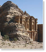
Analyzing Petra's Ruins
Remote sensing and ArcGIS are being used to study changes caused by rapid commercial development and a lack of rainfall to Petra, Jordan, a cultural treasure in the Middle East. Read the article.
Learn to Use Story Map Templates
Every map tells a story. Esri's Bern Szukalski offers some tips on how to get started using the configurable story map templates available in ArcGIS Online.
Ten Great Reasons to Get ArcGIS 10.1
Download ArcGIS Viewer for Silverlight 3.0
Advantage, Cloud: Get Your 30-Day Free Trial of ArcGIS Online
Tell Stories with Maps
Web maps tell stories, whether it's to show people the path of a major hurricane or to compare obesity rates from state to state. You can create these story maps using ArcGIS Online. Read this article to familiarize yourself with the advantages of using maps to tell stories, what type of elements they contain, and how to get started making them.
Using GIS to Plan, Develop
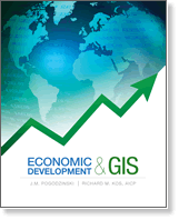
Economic Development and GIS shows you how to use Esri Business Analyst and ArcGIS to help make urban planning and economic development decisions. Written by J. M. Pogodzinski, a professor of economics, and Richard M. Kos, a certified urban planner and educator, this book is an ideal reference for professionals and students. Buy the book.
Newsroom


Improve Data Quality Online
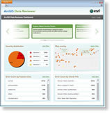
You can now deploy ArcGIS Data Reviewer for Server, which Esri just released this fall. Read this blog post by Esri's Jay Cary to learn how the extension to ArcGIS 10.1 for Server can help improve the data quality control in your organization.
ArcGIS Online Adds CityEngine Web Viewer
Sharing your 3D content just got easier with the addition of CityEngine Web Viewer in the new release of ArcGIS Online. Get the details in this blog post.
Take the New ArcGIS 10.1 Certification Exams
The 10.1 versions of the ArcGIS Desktop Associate and ArcGIS Desktop Professional Esri technical certification exams are now available. Exams are offered at 5,000 Pearson VUE locations in 165 countries. Learn more and register for an exam.
Excel Tips for ArcGIS Online
Esri's Owen Evans explains how to prepare and format your Excel data for publication using ArcGIS Online. Read his blog post.
Heat Up Your Web Maps
Create colorful heat maps using ArcGIS API for JavaScript and HTML Canvas. Read the tip.
Learn to Use Visibility and Range Results in ArcGlobe
Once you've done some visibility analysis with the Visibility and Range template, you may want to view the results in 3D. Read this tip.
Avoid Last-Minute Metadata Misery
Start planning for metadata requests by developing a template that includes standard language for the data's usage and distribution and contact information.
Esri Insider
The Power of the Map
Maps mean different things to different people. John Calkins, corporate technical evangelist for Esri, offers you his unique perspective on what he considers three basic kinds of maps. Read his Esri Insider blog post.Monitoring Sandy with ArcGIS
Superstorm Sandy caused billions of dollars in damage to the East Coast of the United States. View this extensive gallery of web maps and applications that were created by ArcGIS users to track the so-called "Frankenstorm" and to provide people with important information such as power outages.
Go on a Geo Treasure Hunt
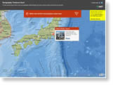
Test your geography skills! Where is the world's most populous urban area, mateys? Find out by taking the Cities of the World treasure hunt. What volcano erupted in 79 A.D.? Take the Mountains of the World treasure hunt to see if you know the answer.
The Government GIO's Leadership Role
Esri state government industry manager Richard Leadbeater explains how information technology changes, combined with the impacts of budget tightening, give geospatial information officers (GIOs) new leadership opportunities. Visit the Spatial Roundtable.
Layout Design Essentials for ArcGIS 10.1
Learn how to place legends, logos, and other map elements to create compelling page layouts during this free live training seminar on layout design on December 6, 2012. Subscribe to receive reminders.
ArcGIS Animation: Mapping the Spread of White Nose Syndrome in Bats
View this ArcGIS 10.1 animation created to map the spread, over time, of white nose syndrome, a disease that's killed more than 5.7 million bats in the United States over the past six years.
Podcast: 3D Mapping Assists in Preserving Historic Sites and Monuments
New Training Courses for ArcGIS 10.1
Esri Welcomes Your GIS Day Success Stories
Hardware Offers
Technical Talk
Web Resources and More

Esri offers US customers Data Appliance for ArcGIS for both Windows and Linux, manufactured by Cutting Edge for Esri. Data Appliance for ArcGIS is a GIS solution with much of the same data content that is available through ArcGIS Online services but deployed behind your firewall. This data is designed and optimized for publishing services to quickly leverage the data for successful geospatial visualization and analysis. Learn more about all the Esri and Cutting Edge offers.
Visit the Esri Store to find more software and extensions, upgrades, data, books, and hardware bundles.