When disaster response agencies, local and state governments, and utility companies support humanitarian and disaster relief efforts, it is critical that they assess the damage in affected areas rapidly while helping reduce risks to life and property. Aerial, drone, and satellite imagery play an important role in aiding analysts who remotely inspect disaster areas.
ArcGIS Excalibur, a web-based imagery analysis app, provides easy-to-use tools and workflows that enable analysts to conduct inspections and assess infrastructure remotely. Later this year, Esri will release ArcGIS Video Server, which will integrate with Excalibur and allow users to index, search, publish, and stream video services with geospatial and temporal context to improve situational awareness.

Critical Tools for Disaster Response
In disaster situations that change quickly and require urgent action, decision-makers and responders rely on analysts to help them understand problems, develop recovery strategies, facilitate search-and-rescue efforts, identify hazards, and document damages. To gather, analyze, and report this information, analysts often use web-based software to look for and access relevant images and videos. With these, they can compare before-and-after scenes, provide geographic context, note changes in objects, record observations, and share the results with their planning teams via reports.
Agencies use the reports generated by analysts to prioritize recovery efforts, document damages to infrastructure, detect cascading impacts, and design future hazard mitigation projects. For example, analysts can use imagery from a previous hurricane to identify areas that are prone to specific hazards, such as repeat flooding, to help decision-makers come up with hazard mitigation projects. Additionally, imagery from previous storms can inform how resources are distributed during current disasters and in anticipation of future natural hazards.
To help organizations quickly and efficiently plan and strategize during disaster response operations, ArcGIS Excalibur makes imagery the main data source. It supports a variety of image services and gives users access to imagery online, via web services, rather than making them available only locally on desktop machines.
ArcGIS Video Server will make it easier for organizations that collect large amounts of video content via drones, security cameras, and sensors to seamlessly integrate this video with all their other data. Video is simply treated as another spatial data source. Playing a server role in ArcGIS Enterprise, Video Server will allow users to create, consume, and view web-enabled video layers in Excalibur and other ArcGIS apps.
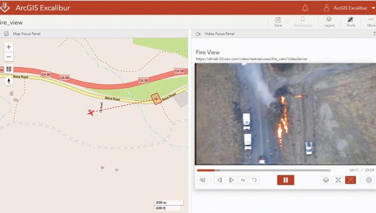
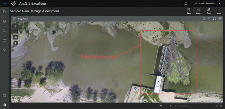
Using Excalibur with Video Server, staff working on disaster relief efforts will be able to access and share archival and live video of impacted areas over the web. From there, they can mark the videos up with their observations, such as missing or moved vehicles, damaged facilities, dams blocked by debris, and fallen power lines. With this intelligence, teams can better plan their emergency operations so that they target areas where search and rescue, debris removal, and utility service restoration are likely to be most effective.
In Excalibur, analysts can also add their observations from the videos to after-action reports and corresponding dashboards to provide stakeholders with timely updates of the current situation. For instance, during the after-action process for a wildfire, when staff from fire departments, government agencies, and disaster relief organizations are appraising how the response went, analysts can extract telemetry data from videos and map it to generate geographic insight about how long it took to respond to certain areas; the total extent of the fire; and where new hazards might present themselves, such as in areas with burn scars. Using Excalibur, analysts can easily measure and count objects in videos and images, conduct visual change detection, and export screenshots to share critical information quickly.

The Key Features of Video Server in Excalibur
Once Excalibur is connected to Video Server, users will be able to access, analyze, and share both imagery and video in Excalibur and extract geospatial information from both kinds of media. Here’s how it will work:
Access Imagery over the Web
Analysts can create new image layers in Excalibur by publishing files stored on local machines as web-enabled services—and they will soon be able to do this for videos, too. By making images and videos available on the web, analysts extend searchable access to them to the rest of the organization. Existing image and video layers can be used as the focus layer in the Imagery Exploitation Canvas to allow users to view, inspect, analyze, and collect observations. Providing web-enabled imagery and video as services is an efficient way to see what image and video layers are available for use.
Analyze Imagery and Play Videos
In Excalibur, analysts can view images—and will soon be able to play videos—right next to a map of the area where the media was recorded so that they can get an immediate geographic reference for them. Within the map panel, the Imagery Exploitation Canvas contains tools that analysts can use to mark up, count, or measure objects in the adjacent image or video. The video player will also include a range of controls to do things such as change playback speed, skip forward or go backward, and mute audio.
Organize Projects and Share Analyses
To stay organized, analysts can create a project in Excalibur and use project-specific tools to generate bookmarks, provide instructions to other users, and collect or edit observations in the map focus panel. They can also use the tools in the Imagery Exploitation Canvas to take screenshots, export images, and create reports.
How to Get Started
ArcGIS Excalibur—with its imagery analysis tools that enable remote inspection—is available now for ArcGIS Enterprise users to purchase. The ArcGIS Video Server release this fall will give analysts access to new video analysis tools and adaptive bitrate streaming (which adjusts video quality based on network conditions), that will make it easier to generate timely insight in Excalibur.
Find out more about ArcGIS Excalibur. Receive notifications about ArcGIS Video Server and find out when it will be available by signing up for product news.

