At the 2023 Esri User Conference, Orange County, California, was one of a select group of outstanding organizations that gave presentations on their work during the Plenary Session. A user of Esri technology since the 1980s, the county has one of the most innovative local government GIS implementations.
The OC Survey is responsible for managing the county’s GIS infrastructure, which makes it a little unusual in local government but has contributed to Orange County’s unique success in implementing GIS. In 1991, OC Survey established a countywide GPS control network and passed a digital submission ordinance requiring all new subdivision maps to be submitted digitally and tied to this grid. Through early adoption of GIS, CAD, and GPS, Orange County has become a leader in surveying and mapping. In the 2000s, the county collaborated with the California Spatial Reference Center to create a real-time network.
ArcGIS is the foundation for the management of the county’s parcel fabric and imagery, lidar, and digital assets, which are all tied to its accurate survey control and has enabled the creation of a digital twin. GIS has been adopted by nine departments and is used extensively by OC Public Works. The county monitors its capital improvement program using ArcGIS Dashboards. The infrastructure at John Wayne Airport—both indoor and outside—is managed with GIS. The Orange County Registrar of Voters uses GIS to make its management of voting both more efficient and secure and uses ArcGIS Dashboards to share election results. The county’s GIS open data portal makes geospatial data and apps available to the public.
According to Orange County surveyor Kevin Hills, these innovative applications of GIS, which provide an exceptional level of services to the county’s three million residents, are a product of the county’s culture, which encourages its employees to be curious, engaged, and inspired. Orange County continually improves the efficiency of its services through expanding its use of GIS and incorporating some of the newest aspects of the technology.

This innovative approach was applied to the operations of Orange County Waste and Recycling. This OC Public Works agency operates three landfills that are among the largest in California. Together, these sites receive more than four million tons of solid waste annually.
Fires are a real concern for landfill managers. According to fire suppression systems company Fire Rover, at least 390 fires were reported at waste and recycling facilities in the United States and Canada in 2022. Monitoring and regulating waste stockpile temperatures is critical to safely maintaining these landfills and mitigating the risk of internal fires that could quickly spread.
Initially, OC Public Works equipped drones with thermal imaging infrared cameras to detect the surface temperature of stockpiles. When the surface of a stockpile reached a specific heat threshold, a staff member was dispatched to manually record the internal temperature of the stockpile. This process helped landfill managers mitigate fire risk but lacked real-time awareness and a method for actively monitoring the stockpile’s internal temperature.
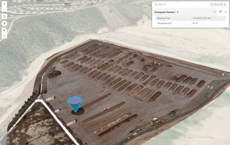
The county was already pulling live data feeds from its fleet vehicles into GIS to proactively manage them and schedule preventative maintenance. County GIS staff realized that live feeds from sensors could be used to monitor waste stockpiles. To automatically record the internal temperature, sensors inserted into each stockpile were attached to Raspberry Pi units, low-cost, credit-card-size computers. Using ArcGIS Velocity, an add-on software as a service offering for ArcGIS Online, staff members fed sensor output data into a web map that showed real-time temperatures within each stockpile.
“For about $40 per device, we can deploy several sensors in different locations within a stockpile and collect precise insights 24/7,” explained Cameron Smith, GIS manager at OC Public Works. “Outsourcing this to a vendor would’ve cost the county tens of thousands of dollars yearly.”

Staff members can also push alerts to managers and landfill personnel when internal temperatures have passed a certain threshold. Sensors improve worker safety by replacing manual temperature probe readings with automatically recorded and reported data and eliminating potential fire hazards. In addition to real-time awareness of stockpile conditions, a dataset of temperature readings can be accumulated and analyzed to look for trends and patterns. Methane and moisture sensors can also be integrated to improve landfill management.
Although the county was already working with regulators to ensure that landfills operate in full compliance with all federal, state, and local codes and regulations, this technology will keep the community and personnel safer and help save county employee hours and taxpayer dollars. Orange County continues expanding its use of GIS to streamline processes, save money, and improve decision-making.