For nearly two decades, I’ve worked with geospatial science and technology across various regions and sectors, including the private sector, academia, and government. Throughout my journey, I have come to recognize the pivotal role of geospatial information in driving sustainable development, not just in the present but also as we chart our path toward achieving the 17 Sustainable Development Goals (SDGs) set forth by the United Nations, beyond the target year 2030.
Acting as our “eye on Earth,” geospatial data allows us to understand our current state, forecast challenges, and identify root causes. For instance, geospatial data plays a crucial role in assessing and monitoring the state of the environment, pinpointing areas of concern, and tracking changes over time.
Geospatial technology, specifically GIS, enables us to analyze spatial patterns and relationships, providing invaluable insight for root cause analysis, targeted interventions, and resource allocation. Through the application of geospatial information, we gain a more profound understanding of complex environmental processes, supporting evidence-based decision-making for sustainable development initiatives.
Geospatial information has the capacity to revolutionize sustainable development by enabling GIS integration into all possible systems. This integration includes creating a real-time digital twin of our world, in which spatial data is woven seamlessly into various domains and sectors. By geoenabling everything, we can enhance decision-making, optimize resource allocation, and enhance the efficiency of infrastructure and services. This integration will result in a comprehensive understanding of the interconnectedness of social, economic, and environmental systems, paving the way for more holistic and effective approaches to sustainable development.
Applying Geospatial Expertise
In my role as a geospatial expert at the United Arab Emirate (UAE) Ministry of Cabinet Affairs, Federal Competitiveness and Statistics Centre (FCSC), as well as during my earlier experiences as a researcher and my collaborative work with the Food and Agriculture Organization (FAO) of the United Nations in Libya, I had the privilege of contributing to multiple real-world projects. These initiatives harnessed geospatial information to advance sustainable development, demonstrating the profound impact that geospatial analytics can have across diverse contexts.
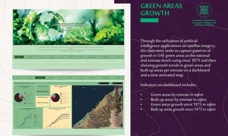
Tracking Growth
FCSC utilized Landsat imagery and National Aeronautics and Space Administration (NASA) night light imagery to monitor the growth of various areas since 1972. Historical Landsat imagery and imagery from the UAE’s Mohammed Bin Rashid Space Centre (MBRSC) helped track changes in green and built-up areas, and the rate of land consumption. NASA night light maps were used to monitor the expansion of night light from 2010. These geospatial visualization capabilities allowed us to understand space-time factors and historical trends related to population, land-use, and economic patterns. Such information is crucial for planning sustainable cities, combating climate change, and protecting terrestrial ecosystems in alignment with the SDGs. (See the UAE 50 Years of Prosperity webpage.) This project aligns with SDG 11: Sustainable Cities and Communities, particularly Target 11.3, which focuses on enhancing inclusive and sustainable urbanization.
Leveraging Earth Observation and Geoartificial Intelligence
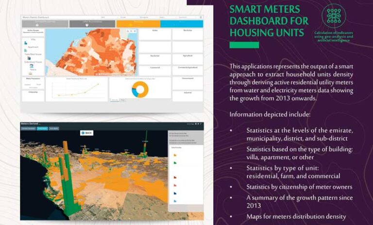
FCSC harnessed the power of geoartificial intelligence in remote sensing to extract meaningful insights from imagery and combine it with administrative data. For instance, in the context of housing and household surveys, we successfully integrated building footprints extracted from satellite imagery with millions of administrative records for electricity meters.
This amalgamation allowed us to discern the use and status of buildings and distinguish between residential and commercial properties. By employing this approach, we significantly reduced the need for physical fieldwork, which saved the government substantial time, effort, and money. Furthermore, these technologies enhanced the quality and accuracy of the information obtained, ultimately more effectively propelling us toward our SDG targets. (See “Smart Meters Data.”)
Geoenabling National Statistics
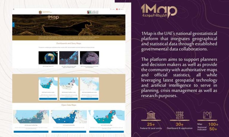
In the UAE, FCSC pioneered two groundbreaking projects: the 1Map and the UAE SDG Data Hub, both of which underscore the transformative potential of geoenabling national statistics.
1Map is the UAE’s national geostatistical platform that integrates geographic and statistical data through established governmental data collaborations. The platform aims to support planners and decision-makers across diverse sectors as well as provide the community with authoritative maps and official statistics through leveraging the latest geospatial and artificial intelligence (AI) technology to support planning, crisis management, and research.
Concurrently, the UAE SDG data hub is a comprehensive platform that aims to track, monitor, and report progress toward the implementation of the SDGs in the UAE and is integrated with the Sustainable Development Goals Data Hub. It features four main elements that make it unique and engaging: open data on SDG indicators, engaging data stories, dynamic initiatives, and a robust media section. (See Data for Good: Innovative Ways the UAE is Joining Hands for a Better World.)
The utilization of geoenabled statistics in both platforms introduces a spatial dimension to the understanding of statistical data, facilitating the extraction of nuanced insights for the development and implementation of more targeted and efficient policies. Such projects underscore the significance of integrating geographical and statistical data and set a benchmark for future endeavors aimed at tackling complex socioeconomic and environmental challenges.
Assessment of Environmental Challenges
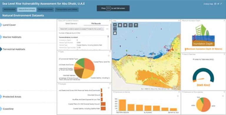
In my master’s degree thesis at Lund University in Sweden, I undertook a study on sea level rise to gauge the vulnerability of coastal cities. A key output of this thesis was a dashboard that effectively organized, summarized, and presented the results of the assessment. The dashboard underscored the vulnerability of Abu Dhabi’s natural and built environment to long-term sea level rise and provided insight derived from surface analysis using geospatial models.
This study aligns with SDG 11–Target 11.5, which focuses on reducing the impacts of disasters and enhancing cities’ resilience to climate-related hazards. By emphasizing the vulnerability of coastal cities to sea level rise, the study contributes to understanding and managing climate risks, promoting sustainable urban development, and enhancing city and settlement resilience. (See Sea Level Rise Vulnerability Assessment for Abu Dhabi, United Arab Emirates.)
Land and Resource Management
Working in collaboration with the Libyan government, the United Nations Development Programme (UNDP), and the FAO, I played an important role in the creation of the Land Resources Information Management Systems (LRIMS) project. This project is a prime example of how GIS-based systems can be used to manage land resource information. With a focus on Libya, this initiative incorporated 10 modules, including climate, soil, vegetation/land cover, water, land suitability, crop, socioeconomic, topography, land utilization types, and reporting tools.

Opportunities and Challenges
As we navigate the intersecting domains of Earth observations and the SDGs, we encounter both opportunities and challenges.
A key factor in the success of the previously mentioned projects was the availability of a wide variety of geospatial data collection and analysis tools. For these diverse initiatives, we utilized both commercial and free satellite imagery, aerial photographs, and digital elevation models. We also drew upon authoritative geospatial databases provided by municipalities and governments, as well as data from ground-based surveys.
In addition, we leveraged platforms such as OpenStreetMap and US Geological Survey (USGS) EarthExplorer, in conjunction with GPS data. Collectively, these resources provided invaluable information about the Earth’s surface, such as land cover, vegetation, climate, infrastructure, population demographics, and community facilities. Certain sources also provided critical, precise, and location-specific data. The breadth of these sources greatly enriches sustainable development projects.
At the same time, collecting and processing geospatial data for sustainable development projects poses several formidable challenges. These include limited data availability and the need to navigate varying data formats and integrate data from multiple sources. Furthermore, data preprocessing tasks such as image calibration, geometric correction, and atmospheric correction can be time-consuming and require specialized knowledge. Adding to these complexities are the costs of acquiring commercial geospatial data and maintaining their updates. Above all, ensuring the quality and accuracy of data is crucial, as any errors or inconsistencies can lead to inaccurate analysis and unreliable results.
Unleashing the Power of Collaboration
Collaboration among different stakeholders from government, the private sector, nongovernmental organizations (NGOs), and academia is crucial for realizing the full potential of geospatial information for sustainable development. By working together, stakeholders can share data, expertise, and resources. This will lead to more comprehensive and cost-efficient solutions.
I have been involved in various projects that have fostered collaborative efforts and led to successful outcomes. Such partnerships not only help reduce cost and increase the quality and scalability of the outputs, but also facilitate knowledge exchange in the process. Partnerships remain at the core of successful SDG implementation since they promote interdisciplinary approaches and enhance the impact of geospatial information on SDG initiatives. This core principle is embodied in SDG 17: Partnerships for the Goals.
For example, the UAE has established multiple national and international partnerships to accelerate the implementation of SDGs. At the national level, the governance structure includes a national committee focused on SDGs, a private sector advisory council, and a youth advisory council that serves as a bridge to communicate between various sectors and the country’s youth. Similarly, academia and civil society are actively engaged through innovative projects.
International relations are equally important. The UAE continually partners with many multilateral organizations to further the SDGs. For instance, the UAE SDG Data Hub was established through significant joint efforts. The United Nations Department of Economic and Social Affairs (UN DESA) not only provided guidance and support but also hosted the centralized Open SDG Data Hub-FIS4SDGs into which UAE’s hub was integrated.
Esri and the UN Statistical Division (UNSD) worked together to design the Sustainable Development Goals data hub, which is the data framework for the UN 2030 agenda. The geospatial web portal connects the UNSD with a network of national-level SDG hubs that form the Federated Information System for the SDGs. It provides insight into the progress on the goals at both national and sub-national levels. The partnership with Esri enabled FCSC to configure the UAE SDG Data Hub and leverage Esri’s geospatial platform ArcGIS. (See “UAE Data Hub Drives Sustainability Goals.”)
Together, these collaborations help make the UAE SDG Data Hub a powerful and award-winning tool. It features an array of best practices, data stories, and open data at the emirate level, incorporating initiatives that span the UAE and include the private sector and nonprofit organizations. In addition, it functions as a tool for creating awareness, shaping culture, and engaging all of society in sustainable development opportunities.
Countries and government organizations also benefit greatly from initiatives such as EO4SDG and the Earth Observations Toolkit for Sustainable Cities and Human Settlements, which serve as lighthouses that guide organizations in the effective use of Earth observation and geospatial intelligence.
These initiatives provide valuable use cases that demonstrate practical applications of these technologies in addressing sustainable development challenges.
By bringing awareness to relevant open data sources, these initiatives help ensure access to relevant and reliable information for decision-making. Additionally, they underscore the power of collaboration, fostering partnerships among diverse stakeholders to collectively leverage Earth observation and geospatial data for the realization of the SDGs and the development of sustainable cities and human settlements.
Looking to the Future
As the geospatial industry evolves, I foresee several trends emerging, the most notable one being the increasing availability of high-resolution satellite imagery, coupled with the advancement of remote sensing technologies. This development will enable more detailed and accurate monitoring of environmental changes, supporting targeted interventions and adaptive management approaches. The fusion of geospatial data with other emerging technologies such as machine learning and big data analytics will enhance the capabilities of geospatial information systems and enable more sophisticated analysis and decision-making.
Citizen science and participatory mapping can have a significant impact on achieving sustainability. By involving citizens in the process, communities are empowered to contribute invaluable information and local knowledge. The community can contribute by mapping, collecting, and monitoring data; conducting spatial analysis and modeling; supporting spatial planning and land management; developing decision support systems; and advocating for geospatial information in policy formulation. Through these endeavors, citizen scientists enable the collection of geospatial data at multiple scales. This fosters community engagement, heightens environmental awareness, and propels sustainable development efforts forward.
Finally, collaboration and partnerships will continue to be integral in refining the SDG agenda. They will serve as the bedrock for ensuring evidence-based decision-making and successfully addressing complex spatial challenges. As we continue leveraging geospatial information, cooperation can guide us along the path toward a sustainable future.
This article originally appeared on eo4sdg.org.
About the author