In response to the opaque rental housing market in Beirut, Lebanon, a university research lab created a database of rental information contributed by tenants and shared it with home seekers, tenants, researchers, and housing advocates through an online map.
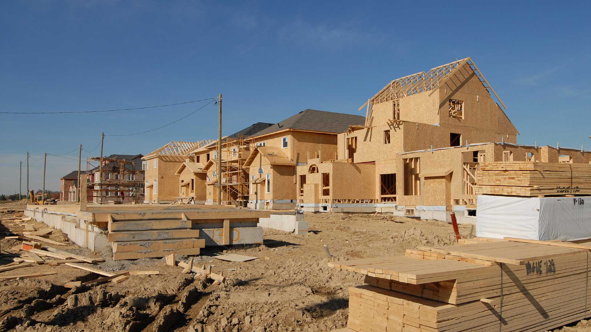
In Beirut, the civil war and the repeal of rent control have led to high rent prices that aren’t aligned with renters’ ability to pay. In some cases, the tight housing market has forced tenants to sign leases spanning multiple years, often paying years in advance.
As the capital and largest city in Lebanon, Beirut has a host of housing concerns that have been exacerbated by population growth. With recent stabilization in the region, property management companies and property owners have flocked to neighborhoods of Beirut and transformed them to attract tenants willing and able to pay higher rents. This has displaced those with lower incomes, compelling them to move to areas that are further away from the city center and jobs.
In this period of housing uncertainty, many residents and potential renters need access to rental market information. The lack of transparency in the rental market has generated severe inequities among city dwellers. This situation has especially disadvantaged the most vulnerable social groups, who often pay high rates for substandard units. The lack of information about housing quality and pricing has increasingly become a substantial hurdle for those looking to rent.
Rental Data in Geographic Context
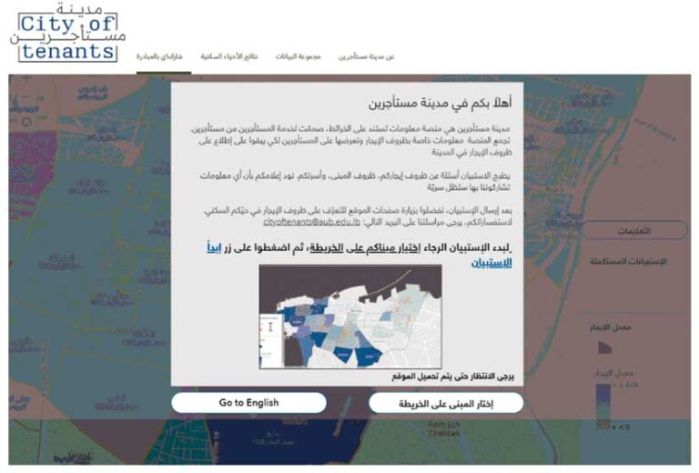
To improve the situation for renters, the Beirut Urban Lab built the City of Tenants, an online platform based on a database of tenant-contributed information and visualized using GIS to map that information. The Beirut Urban Lab is an interdisciplinary research lab that was founded in 2018 in the Maroun Semaan Faculty of Engineering and Architecture (MSFEA) of the American University of Beirut. The lab has been collaborating with scholars, researchers, institutions, public agencies, activists, professional groups, grassroot collectives, and local communities on multiple interdisciplinary projects. These projects rely on mapping as an analytical research method and effective communication tool.
With the City of Tenants, the Beirut Urban Lab could integrate data about rental conditions such as rent prices, and neighborhood characteristics within a location-based context. The lab had built an accurate basemap, the Beirut Built Environment database, that includes footprints, property boundaries, roads, sewer networks, and Electricité du Liban’s official neighborhood divisions for the city. It will be updated regularly with layers to reflect ongoing research and data collection.
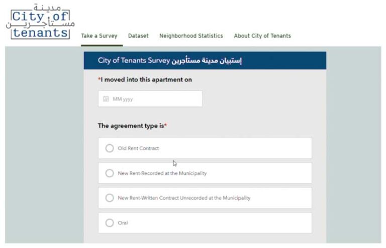
With the Beirut Built Environment database as a foundation, the City of Tenants incorporates ArcGIS Survey123 and ArcGIS Experience Builder to collect data about the occupancy status of rental units. A web app, built using ArcGIS Experience Builder, allows the data collected to be displayed in a compelling web application on a single screen. It contains embedded ArcGIS Dashboards modules and has been optimized for Arabic and English. Its functionality extends to desktop and mobile devices, and a hub site brings together spatial and environmental characteristics.
The rental data is anonymously collected, using ArcGIS Survey123, from current tenants living in neighborhoods in throughout Beirut. Users quickly answer questions in the form and the collected data is immediately uploaded to the ArcGIS system. Tenants provide their email addresses to access the survey. Researchers and other professionals use the data to explore urban trends in Beirut.
With the City of Tenants geoportal, tenants and researchers can log rental costs in relation to housing conditions for rented-out units. This information, shared in an accessible and clear form, improves home seekers’ knowledge on existing housing conditions and can help counter the ongoing reliance on asking prices, which are often inflated.
“The mapping component is an integral part of the City of Tenants platform. It allows for georeferencing of the data, which in turn provides critical insights about the correlation of rent and neighborhood characteristics,” said Mona Fawaz, professor of urban studies and planning for the American University of Beirut and cofounder of the Beirut Urban Lab.
A Better View of City Housing
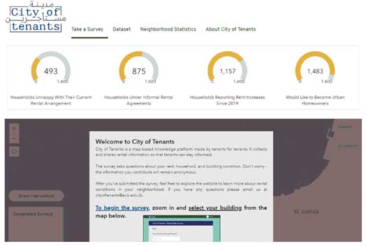
The City of Tenants platform launched with 1,800 data points collected between December 2021 and December 2022. Data collection is ongoing. Market visibility is a necessary first step toward the formulation of responsive public policies for the rental sector that will ultimately serve the goals of housing justice. Policy makers can also rely on the City of Tenants platform to understand gaps in the rental market, price gouging, and other factors when creating public policies.
Readily available data on modes of payment, rent prices, apartment sizes, building conditions, number of occupants, and the age of housing helps tenants—both current and future. With more and better rental information, tenants reduce the time spent searching for adequate housing options and more effectively negotiate with property owners. Access to publicly available rental market data empowers potential renters’ decision-making to create more favorable rental conditions for themselves.
“We are still in the analysis phase of this project, but we are collecting information across 20 variables including cost and type of utilities, currency of rent payment, and formality of agreement, and others,” said Fawaz.
D
ata collected thus far indicates that rents for similar apartments in similar locations vary substantially. Fifty percent of responding households reported relying on oral contracts, and another 15 percent have written contracts that were not recorded at the municipality. Households are heavily burdened by rent. The cost of rent and basic services such as electricity, water, and building services raised that burden to 95 percent of income for households surveyed. Consequently, these households depend on financial aid or help from relatives to make ends meet.
In the future, the Beirut Urban Lab hopes to expand the City of Tenants to other cities in Lebanon. The lab further hopes to develop the platform so that data is automatically updated based on data gathered via ArcGIS Survey123.