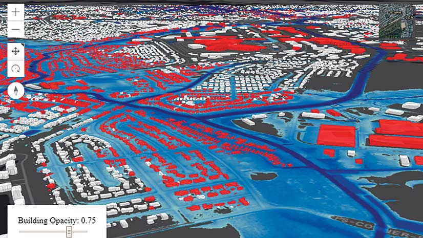
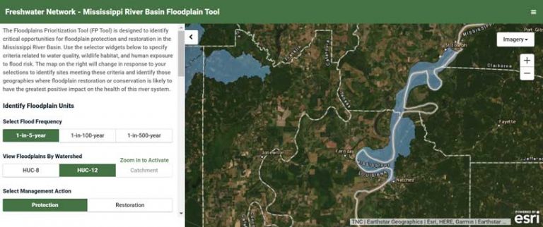
As planners, land trusts, and government officials look for ways to protect communities from flooding and safeguard water supplies, they’re increasingly looking to natural solutions, like protecting or restoring floodplains. But in places as vast as the Mississippi River basin, which floodplains are most valuable? Which places—if protected or restored—will provide the best defense for communities given the money spent?
Thanks to the sophisticated use of GIS, a solution is now available. Developed by The Nature Conservancy (TNC) and partners using Esri’s ArcGIS, the Floodplain Prioritization Tool (FP Tool) can help communities throughout much of the Mississippi River basin decide where and how best to use limited financial resources to protect or restore floodplains.
“Protecting and restoring floodplains help reduce flooding and avoid damages from further development of flood-prone lands, while providing improved habitat for fish and wildlife and offering people improved water quality and recreational opportunities,” said Kris Johnson, who led development of the tool. Johnson is the TNC deputy director of agriculture for North America.
“We wanted to provide a science-based tool that can help decision-makers—like [those in] federal, state, and local governments; county planners; land trusts; and businesses—optimize their protection and restoration investments and minimize the impacts of development,” Johnson added. “The FP Tool does just that. It’s designed to help guide investments and assess trade-offs related to different goals, like water quality, wildlife habitat, and estimated flood damages.”
Handling a Lot of Data
Developing the FP Tool relied on refining a huge amount of data from government agencies and natural resource organizations. The University of Iowa; the University of Bristol in the United Kingdom; and Fathom, a flood risk analysis company also based in the United Kingdom; provided data for the tool that had been previously unavailable to the public.
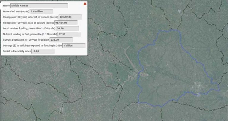
ArcGIS Desktop was essential in creating the tool, said Eugene Yacobson, a conservation information manager for TNC. “The FP Tool analysis included more than 15 data layers and covers a study area that spans approximately 23 percent of the continental US,” he said. “Analyzing that data was carried out primarily using features within Esri’s ArcGIS Desktop.” Yacobson explained that the tool has multiple modes including three flood frequencies and two management actions. This meant that each data layer needed to be processed multiple times with small variations in workflow, so scripting and automation were essential for carrying out the process efficiently and keeping the process both well documented and replicable.
The integration of ArcGIS with the Python programming language via the ArcPy module made this simple. Complex table manipulations could be carried out in Python, those tables joined to spatial layers, and the layers fed directly into tools in ArcGIS. “Python integration also made it possible to do multiprocessing to take advantage of multiple CPU cores to rapidly crunch through 30-meter-resolution floodplain raster layers stretching from North Dakota to Louisiana and eastern Colorado to northwest Pennsylvania,” said Yacobson.
The project’s other goal involved producing a tool that could be employed by a wide range of online users. TNC senior web developer Casey Schneebeck used ArcGIS API for JavaScript to build an online presence for the tool that’s easy to navigate and can direct users to practical, tangible solutions for communities. Although the tool was initially built for the Mississippi River basin, it could potentially be used across the continental United States.
The Need for More Solutions
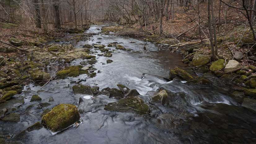
“In the past, you might have portions of large, thousand-acre-plus floodplains that flooded every 25 or 30 years,” said Colin Wellenkamp, director of the Mississippi River Cities and Towns Initiative, an association of mayors from cities along the Mississippi River corridor. “Now we’re seeing entire floodplains flood more often, and they’re inundated with water for months at a time. If we have to go through many more years like 2019, natural assets like floodplains will be the only way we’ll be able to deal with the impacts of flooding, which are becoming worse.”
With more frequent and more intense floods, floodplains can provide communities with efficient and effective solutions. Flood protection, water filtration, wildlife habitat, and other services supplied by floodplains have dollar values, according to Wellenkamp. “The Floodplain Prioritization Tool can help us guide protection or restoration investments or better understand the impacts of the development choices we make.” Wellenkamp also believes the science-based reports that the tool generates can help communities when applying for federal, state, or county grants aimed at reducing flood risks or improving water quality or wildlife habitat.
A new study by TNC and its partners attempted to determine which floodplain strategy would cost American taxpayers more. Based on current projections, should undeveloped areas that are likely to flood in the coming decades be protected now, or should development be allowed to proceed and the subsequent flood damages to be paid for when they inevitably occur?
The study, “A benefit-cost analysis of floodplain land acquisition for US flood damage reduction,” was published in the December 9, 2019, issue of Nature Sustainability. It identified more than 104,000 square miles—an area roughly the size of Colorado—located in 100-year floodplains where conservation would be an economically sound way to avoid future flood damage.

“For just over 21,000 square miles of this area, the benefits are at least five times the cost, meaning that a dollar invested in floodplain protection today returns at least five dollars in savings from avoided flood damages in the future,” said Johnson.
See the Floodplain Prioritization Tool. For more information, contact Jay Harrod.
Acknowledgments
The development of the FP Tool was supported in part by the Enterprise Rent-A-Car Foundation and the McKnight Foundation. Thanks to the partner organizations that contributed data used in the basin-wide version of the FP Tool. These partners included US Geological Survey, US Army Corps of Engineers, US Environmental Protection Agency, National Fish Habitat Partnership, US Fish and Wildlife Service, American Bird Conservancy, Natural Resources Conservation Service, and USA National Phenology Network. Project partners the University of Bristol, United Kingdom; Fathom; and the University of Iowa provided data that was previously unavailable online.
About the author